

frd
-
Posts
7,161 -
Joined
-
Last visited
Content Type
Profiles
Blogs
Forums
American Weather
Media Demo
Store
Gallery
Everything posted by frd
-
Here we go again. Flood Watch National Weather Service Mount Holly NJ 210 PM EDT Wed Jul 30 2025 DEZ001-NJZ009-010-012-013-015>019-027-PAZ070-071-101>106-311000- /O.NEW.KPHI.FA.A.0010.250731T1800Z-250801T1000Z/ /00000.0.ER.000000T0000Z.000000T0000Z.000000T0000Z.OO/ New Castle-Hunterdon-Somerset-Middlesex-Western Monmouth-Mercer- Salem-Gloucester-Camden-Northwestern Burlington-Southeastern Burlington-Delaware-Philadelphia-Western Chester-Eastern Chester- Western Montgomery-Eastern Montgomery-Upper Bucks-Lower Bucks- Including the cities of Moorestown, Pottstown, Trenton, Pennsville, Perkasie, Doylestown, Honey Brook, Morrisville, Glassboro, Norristown, Camden, Somerville, Cherry Hill, Mount Holly, New Brunswick, Lansdale, Media, West Chester, Oxford, Flemington, Kennett Square, Chalfont, Wilmington, Freehold, Philadelphia, Collegeville, and Wharton State Forest 210 PM EDT Wed Jul 30 2025 ...FLOOD WATCH IN EFFECT FROM THURSDAY AFTERNOON THROUGH LATE THURSDAY NIGHT... * WHAT...Flash flooding caused by excessive rainfall is possible. * WHERE...Portions of northern Delaware, including the following area, New Castle, New Jersey, including the following areas, Camden, Gloucester, Hunterdon, Mercer, Middlesex, Northwestern Burlington, Salem, Somerset, Southeastern Burlington and Western Monmouth, and southeast Pennsylvania, including the following areas, Delaware, Eastern Chester, Eastern Montgomery, Lower Bucks, Philadelphia, Upper Bucks, Western Chester and Western Montgomery. * WHEN...From Thursday afternoon through late Thursday night. * IMPACTS...Excessive runoff may result in flooding of rivers, creeks, streams, and other low-lying and flood-prone locations. Creeks and streams may rise out of their banks. Flooding may occur in poor drainage and urban areas. Storm drains and ditches may become clogged with debris. * ADDITIONAL DETAILS... - A warm and increasingly humid airmass will be in place ahead of an approaching cold front that will pass through the region Thursday night. Showers and thunderstorms will be capable of heavy rain resulting in rainfall amounts of 2 to 4 inches with 6 inches or more in localized areas. Rainfall rates may exceed 2 inches per hour. - http://www.weather.gov/safety/flood PRECAUTIONARY/PREPAREDNESS ACTIONS... You should monitor later forecasts and be prepared to take action should Flash Flood Warnings be issued. && $$
-
Yes, and a great AFD by Mount Holly. Of note, highest FF potential is near and NW of I 95, and the latest models are going with a faster convective progression. The greater flash flood threat should hold off until the daytime Thursday though. && .SHORT TERM /THURSDAY THROUGH FRIDAY/... Widespread showers and thunderstorms are forecast on Thursday, which will pose a risk of flash flooding. Much cooler, breezy, and showery conditions are expected to follow on Friday. The ridging to our southwest will continue to shift eastward through Thursday, with high pressure remaining offshore at the surface. Broad upper diffluence will remain in place aloft through Friday. Meanwhile, a slow moving cold front is expected to push gradually southward Thursday through Thursday night. This should result in some weak cyclogenesis in the Mid Atlantic region as the front works its way south, with the surface low passing offshore on Friday. There remains a threat of flash flooding for Thursday afternoon and evening, as widespread showers and thunderstorms are anticipated to develop within the vicinity of the slow moving frontal boundary. PoPs were remain near 70-80% for the entire area, peaking from north to south as the front moves gradually southward through Thursday night. As diurnal instability builds ahead of the front into the afternoon, PWats will increase into the 2.0-2.5 inch range. Mean layer flow will be roughly parallel to the frontal boundary, which could support training convection. The latest guidance has trended a bit faster with the frontal and convective progression, which could limit a more widespread flash flood potential. Cyclogensis nearby could also introduce some frontogenetic forcing into the equation as well. The synoptic aspects of this setup will probably lead to convection continuing into the overnight period as well. Exact details on the evolution of the convection and flash flood threat remain unclear, as the mesoscale details remain to be seen. Our current rainfall forecast ranges from around 1-2" across the area, but locally higher amounts of 3" or greater are certainly possible. The flash flood threat will ultimately depend on where the heaviest rain sets up, and how quickly convection is propagating. The higher threat for flash flooding will probably end up being in the usual locations near and northwest of I-95. WPC has maintained a Slight Risk of excessive rainfall leading to flash flooding for the entire area. A few isolated severe thunderstorms with damaging winds are possible as well, but the main threat will be the flash flooding potential. Remain alert for updates to the forecast regarding these threats.
-
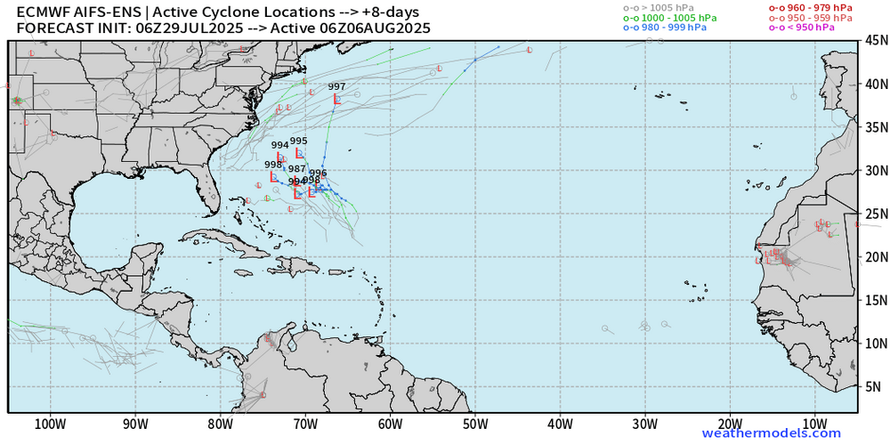
Well, appears the AI models need some more teaching and learning before they can predict tropical storm and hurricane formations. Andy Hazelton @AndyHazelton 1h Central Atlantic waves are pretty convection-free at the moment, as background stability and dry air suppresses rising motion. Not surprisingly, there isn't much model signal for development anymore - the AI models seemed to have been overzealous. For now it seems like physics-based models (e.g. GFS, Euro, and their ensembles) are still our best bet for sniffing out potential TC formation.
.thumb.png.2c30e7e960ed14b6503819a777f1e9e0.png)
-
Things should start to ramp up a bit
-
90/74 heat index is 99 at 10:00 AM ugh.
-
I seriously had to look several times because I know that we were in deep purple, but it's intriguing that the map seemed to have updated it even after you copy and pasted it. They definitely lowered rainfall totals in the range of 1 to 3 days. I could still use an inch though.
-
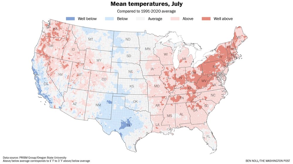
What a look for early August.
.thumb.png.3ec09e2be5118b439842018576cebf60.png)
-
Well, the area of heavier storms weakened as it neared this area, but still managed .25 so that brings me to roughly 1.25 " for the last 24 hours. I am thinking I will let the grass go for two days, even with temps of 94 and 95 with the expectation of rainfall Wednesday night through early Friday morning. Lawn disease and garden blight have been off the charts bad here due to high overnight lows, and very high dew points. Having the lawn dry out a bit will be a good idea.
-
Missed the second round of storms a couple hours ago, but currently looking at another area of heavy rainfall near Calvert Acres and Fair Hill, MD moving generally SE/ESE.
-
What an explosion of cloud tops over North Central Va., and to a lesser extent of SE PA last 90 minutes https://www.star.nesdis.noaa.gov/GOES/sector_band.php?sat=G19§or=ne&band=GEOCOLOR&length=24
-
Picked up an additional .30 , that plus last night gives me .94. Appears another area of storms will drop down from Se PA and NE MD. Very active July for sure !
-
Incoming storm from the NW , didn't think I would get in on this round. Lots of distant thunder but so far not much rain, yet.
-
That could be a big rain producing period, then its Fall. ( for a couple days )
-
Have to keep an eye on possible training storms later for the potential of flash flooding. Mount Holly AFD mentions that the Southeastern portion of the forecast area has a marginal risk for training storms, other areas are slight risk. As we get into the afternoon, increasing instability across the area with daytime heating will result in showers and thunderstorms developing through much of the remainder of the day. Likely and categorical pops will continue in the forecast. These showers and storms will be very efficient rain producers resulting in the potential for heavy rainfall. Storm motions look to be fast enough to keep the threat for flooding localized but if storms repetitively train over an area, the threat for flash flooding will be higher. WPC has a SLIGHT risk for much of the area with a MARGINAL risk for the southeastern portion of the region where the threat for training thunderstorms is slightly less. SPC maintains a MARGINAL risk for severe thunderstorms too with damaging winds as the primary threat.
-
July so far
-
.65 overnight. Good old fashion thunderstorm.
-
.15 last evening.
-
Yup, having a moderate shower here currently. Could have been better, as the earlier storm missed to the East.
-
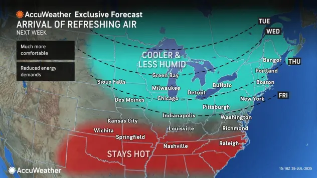
Yes, will be cool to see how it unfolds. meanwhile Accuweather on the cool down bus.
-
92/77 heat index 106
-
From the WPC Day 6 to 7 By Wednesday and especially Thursday the cold fronts slowly pushing south could provide a focus for enhanced rain amounts in the East, which will be refined in future forecasts.
.gif.41258e502e87fca9504e59742d8f5e4d.gif)
-
Currently 88/76 here with a heat index of 99. You might think its bad here, thankfully we do not have to deal with corn sweat.
-
Maybe we start to get some better surfing waves by the mid to third week of August, not too crazy please, but maybe just enough to make if more interesting.
-
https://x.com/webberweather/status/1948522507922792876 Interestng read from Webber
-
Mid Atlantic surf zone and offshore SSTs are on fire compared to last year at this time.
.png.637922cb7c33ef783affb04216372f54.png)

.png.399afdb7bd6f66ddea4afb5be98f80eb.png)


.png.7c450a5d8cab405c01df622dfd50fccb.png)

