

frd
-
Posts
6,928 -
Joined
-
Last visited
Content Type
Profiles
Blogs
Forums
American Weather
Media Demo
Store
Gallery
Everything posted by frd
-
My favorite spot. Fri or Sat AM with North winds and excellent surf. Be safe .
-
A wet, ocean spray day at Dewey today. Forecast of sun from earlier in the week sadly incorrect in this summer of clouds and rain. Surf zone with 3 to 4 foot waves, Thursday is the day for peak surf.
-
.35 here. Good storm.
-
That complex that was moving SE from Lancaster, PA. is now turned more Southerly and dropping almost due South. It is now warned for the extreme Northern part of the Chessy and the Elk Neck State Park and other areas in the Northeast part of the Eastern Shore,
-
Big storms to my far NW, and radar shows a outflow boundary moving South, hmm.
-
Very oppressive today. 91/73 presently, but feels much worse. Going to Dewey Beach tomorrow, yee ha !!!!! Should I bring a body board ?
-
Typhoon League?
-
OMG, you didn't go there.
-
October snow is an Omen for the following Winter.
-
Erin went from tropical storm to Cat 4 hurricane in 24 hours !
-
I would be surprised if this did not make a cat 5 intensity.
-
https://www.surfline.com/surf-report/rambler-road/5842041f4e65fad6a7708b60?referral=msw&view=table Various surf models with 5 to 10 foot waves on Thursday, as the peak day for swells from Erin. Stellar surfing day, but admit you got to be strong will to do so. For today across all beaches a low risk of ripe tides. For Saturday from Mount Holly For Saturday, northeast winds will be around 10 mph with breaking waves around 2 feet. There will be a light easterly swell with a period of 4 to 5 seconds. As a result, there is a LOW risk for the development of dangerous and life threatening rip currents at the Jersey Shore and at Delaware Beaches on Saturday.
-
80/70 this morning. Been way worse than that the past weeks.
-
Well, luck was needed, and it delivered. Between yesterday's storms and this afternoon's storms, that were very impressive, a total of 2.52 inches. Scanning nearby areas that are only a few miles away, Middletown, the actual town .86 , Townsend .32, Odessa .85 Was a game of just miles.
-
Getting hit hard again by a cluster of thunderstorms. The area of heavy rain is generally moving SE.
-
The cool weather potential might have been reduced a bit, but still better next week than this week. The core of the heat settles in the West.
.thumb.png.665c667bbc4596f57db28041a082205c.png)
-
This did work out for some areas of the upper Eastern Shore last evening. Chesapeake City with over 2 inches, my location with 1.50 inches.
-
Pretty crazy in extreme NE Maryland and Northern DE. Pouring here, with booms of thunder, lost power twice already, luckily it came back on rather quickly.
-
Will be interesting to see storm development in the next few hours on the upper Eastern Shore, maybe some interactions from earlier storm outflows. Storms are developing East of Baltimore and West of the Aberdeen Proving Ground.
-
This will be missed.
-
Soil moisture is diving down rapidly. Needing rain is an understatement.
-
It's a rain Forrest out there.
-
Soil moisture levels here in the top 0 to 10 cm level have gone from 30 % on August 1 st to 22.77 % today. The lawn still looks decent only because recent air temps have caused a lowering of soil temps from 82 degrees F. on July 30 th to 72 degrees F. on August 9th. With the heatwave starting, and little to no rain this week, lawns and vegetation will be stressed. Wonder if a we get a Sept return of last year with extreme dryness.
-
That look would be enjoyable. Also, would keep Atlantic hurricanes away.
-
Look at these water temps, wow !
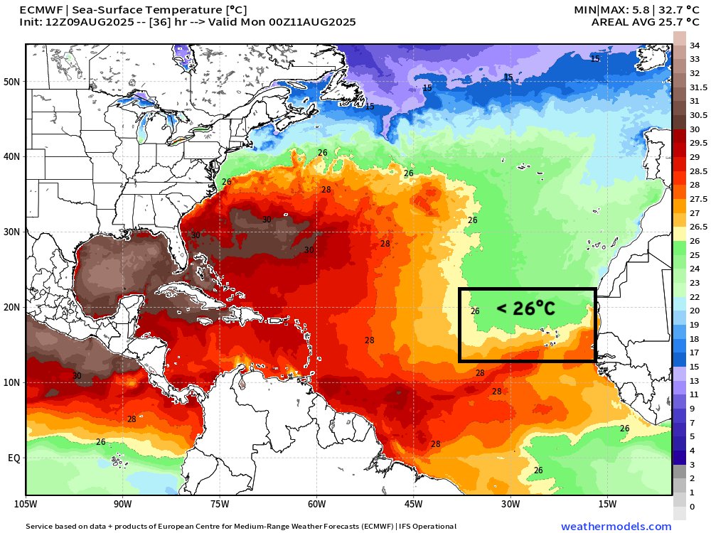


.png.e1c4baae78d7347e65e49f6942a1c8fb.png)