

frd
-
Posts
6,934 -
Joined
-
Last visited
Content Type
Profiles
Blogs
Forums
American Weather
Media Demo
Store
Gallery
Everything posted by frd
-
@CAPE Interesting
-
Speculation on my part that maybe the pattern is possibly showing a tendency for a different outcome at times during the winter regarding the North Pac ridge and Western ridging. Again not sure how things evolve as we get deeper into the Fall season. It seems the last 3 years were all November and EARLY December head fakes, as the real winter pattern did not take hold until post December 20th.
-
We are getting our winter now and in early October. By the way, Western fires are not the only location in the NH spewing aerosol and other elements into the atmosphere.
-
The Euro has not been that great recently, and I hate the weeklies ( flip flops and all ), but there is a general consensus for a possible average to below average October in these parts.
-
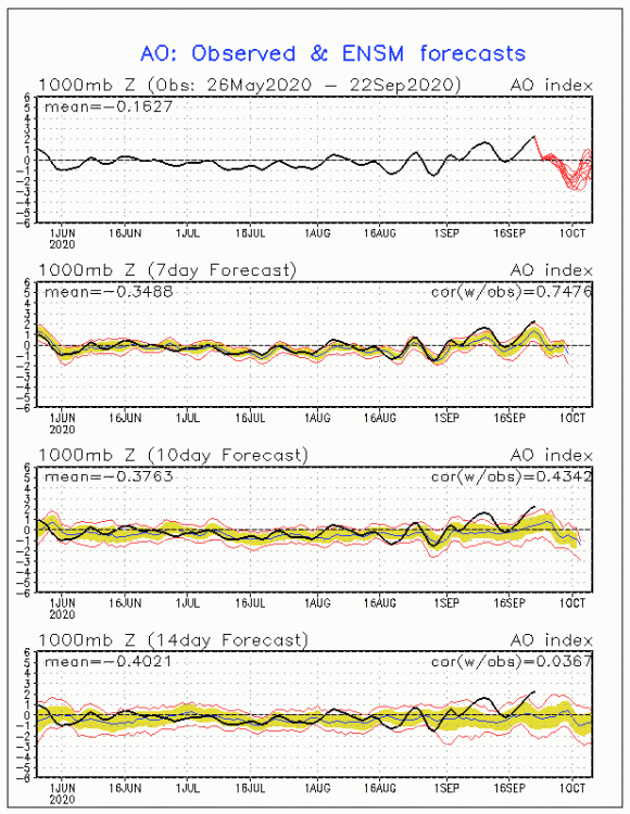
Not saying there is a correlation, someone needs to confirm, but the Northern Atlantic is crazy and wondering about wave breaking as the NAO is set to tank on some modeling and the AO is a going down too . Teddy producing some crazy winds and waves as well. Also, of interest , is the changing SST anomaly near the East Coast from the constant stream of swells and upwelling the past several weeks produced by the recent offshore hurricanes.
-
After the cold shot mentioned above, maybe a Gulf Hurricane.
-
I could be mistaken, but I believe he was attempting to match the progression that could be possible this late fall and the upcoming winter . Granted it was a feeble Nino last winter, but I believe that was his goal. Future QBO numbers will be very interesting as we move deeper into the Fall season. Are you looking at where the IO forcing set ups later this month, and in October, for any winter clues? I ask because bluewave posted a week or so back that depending where the forcing sets up, it has a role in the upcoming winter's temperatures and I imagine the background state. I have to go back and locate it . Well worth the read. I found it , here you go : < We would need to see all that IO forcing shift east toward the Maritime Continent in October. The big amped up MJO 5 in October 2017 came before the snowy La Niña 17-18 winter. The strong IO MJO 1 in October 2011 preceded the 11-12 La Niña winter. There is some research that early IO forcing can excite the PV like we saw last winter. >
-
@CAPE remember what we learned the last two years........ no matter the perceived clue and no matter the head fake , especially good ones that might entice your positive winter vibes, don't be fooled! Ha ha...... I know you know this, but here we go again. And we are talking it is September 22 nd. How things evolve remain uncertain. Saw this last year in October and especially that November period, when postings here commented and reflected that maybe we would get - AO periods and HL blocking, even though the NAO look was not that great.
-
OMG...... To me, Ryan has an agenda. He has morphed into posting some crazy stuff the last several months on Twitter.
-
I assume you are referring to " I take credit where I shouldn't Judah Cohen " ? His part of the message here was attached as a reply to Simmon , however, Simmon Lee is rather sensible and much more proficient than Judah. Simmon knows his stuff.
-
@WinterWxLuvr to possible improve your perceptions, away from the PNA and looking for at least some positives for the upcoming winter I give you this ( below ) . Like to see this November, but I will take what I can given the latest climate model outlooks for the upcoming winter. Posting this here, versus the winter thread, because it is happening now and also to go along with your comment about the PNA.
-
I share your sentiment, but hopefully the winter outcome will at least go our way some of the times.
-
I have followed the PNA, EPO, NAO and AO for decades, but this is one crazy drop and rebound for the PNA. If true, expect some interesting weather.
.thumb.gif.1b3682fef6d4209df9bb8fab63275c25.gif)
-
This recent cool to cold period in our area is even more impressive when you consider it bucks the trend of the last 10 years, and also counters what in our area is the month with the most warming compared to normal during the past 30 years. Indeed, as mentioned before, the warm Atlantic has extended the summer well into October many times here recently. Many locations have set record highs late in the warm season on the periphery of the warm Western Atlantic waters/ WAR .
-
Any comment regarding the IOD being totally opposite last year ? Long range models seem to indicate it goes more so negative as the year ends. Nothing like last year with the extreme positive values in December and continuing into Jan.
-
Been watching the satellite animation and it is making progress my way. Just took my Greyhound for a mid day walk, very breezy and cooler. I admit, I do miss the blue sky look, has been a week with only haze, smoke or simply cloudy. Have a great weekend mappy !
-
We have new records.
-
I believe Ninas may tend to have colder Decembers versus Jan. and Feb. Means nothing, and I am not endorsing a cold December at this point. However, exposed waters above Alasaka and general SST forcing way up North may have a role in our sensible early winter weather before the most powerful and direct pattern weather drivers take hold for the East.
-
Does make sense. The exact location of anomalies and how strong in mid to late Fall will be very important in attempting a December forecast.
-
Yummy.... the Holly Grail
-
BAMWX put together a very detailed and research based presentation rich with relevant data and analogs for the winter outlook of 19-20. The presentation was over 30 minutes long, given in November of 2019 for the winter of 19-20. Guess what, they blew it, they had to back pedal until stating they were wrong. They were very confident in a cold winter. Going too cold and too snowy overall. Of course they spin it, by stating they adjusted their winter forecast to counter their early seasonal forecast. In my opinion, that is still a fail. No one really knows what is going to happen. After two years of incredible busts regarding winter outlooks by everyone, the bottom line is that you should never put faith in a winter seasonal forecast that depends on cold air intrusions. It is a different climate now, with new evolving drivers on a global scale. You can even share the insights and opinion of tip over in the New England forum, whom states that regardless of Nina or Nino it does not matter at all, because a small area of the Pacific cannot counter the global warmth and the corresponding accelerating global warmth drivers.
-
In the short term yes. As in today, temps in this region will average 2 to 5 degrees lower versus without the smoke effect on solar energy. However, this is an interesting thread below discussing the effects of Western fires on the stratosphere. As Anthony points out some interesting outcomes on the winter AO and even the development of the early season PV. The thing that interests me the most is that in the Nature. com abstract below it discusses the 2017 " Pacific Northwest event " . Keep in mind that the current fires on the West Coast and other areas are far more impressive in terms of release. Also, keep in mind the similarities , as mentioned in the abstract of volcanic intrusions. Also there is this literature https://www.nature.com/articles/s41612-018-0039-3 Abstract Intense heating by wildfires can generate deep, smoke-infused thunderstorms, known as pyrocumulonimbus (pyroCb), which can release a large quantity of smoke particles above jet aircraft cruising altitudes. Injections of pyroCb smoke into the lower stratosphere have gained increasing attention over the past 15 years due to the rapid proliferation of satellite remote sensing tools. Impacts from volcanic eruptions and other troposphere-to-stratosphere exchange processes on stratospheric radiative and chemical equilibrium are well recognized and monitored. However, the role of pyroCb smoke in the climate system has yet to be acknowledged. Here, we show that the mass of smoke aerosol particles injected into the lower stratosphere from five near-simultaneous intense pyroCbs occurring in western North America on 12 August 2017 was comparable to that of a moderate volcanic eruption, and an order of magnitude larger than previous benchmarks for extreme pyroCb activity. The resulting stratospheric plume encircled the Northern Hemisphere over several months. By characterizing this event, we conclude that pyroCb activity, considered as either large singular events, or a full fire season inventory, significantly perturb the lower stratosphere in a manner comparable with infrequent volcanic intrusions.
-
Fascinating smoke effect on temps today, as discussed by Mount Holly in the near term update: NEAR TERM /UNTIL 6 PM THIS EVENING/... Smoke from the western wildfires continues to have an impact on the region and is expected to remain over the forecast area today. The SO2 GOES RGB product highlights the thickest concentration generally from around central PA/NJ northwards. With the lack of in person observers overnight many of the ASOS`s are now indicating clear skies but expect that to change with day break. In coordination with surrounding offices, we`ve increased the forecast sky cover to reflect that conditions this afternoon will be rather hazy although not "cloudy". The net effect on the weather will be that temperature will not warm quite as much as they would under typical clear sky days. So I`ve undercut temperature guidance by around 3-5 degrees suggesting highs this afternoon should be around 70. Normal for mid September should have highs in the mid to upper 70s so with the smoke aloft we`ll be below normal with relative ease even under southerly warm air advection.
-
Actually it is deary outside, beyond the temps. With the lower sun angle will take some time to get some real sunlight to filter through. Forecasts should do away with sunny and replace with haze and or smoke. Heard tomorrow may be worse as the smoke is closer to ground level.
-
Surreal look at sunrise with crisp Fall like air, yet a milky, smoky sky above. Temp at a remarkable 47 degrees here at 630 AM. What a quick turn around from just a couple weeks ago.


.gif.ebffb3afb23087ee48530f2cb8aa2c84.gif)

