frd
-
Posts
6,934 -
Joined
-
Last visited
Content Type
Profiles
Blogs
Forums
American Weather
Media Demo
Store
Gallery
Everything posted by frd
-
That must be mostly Siberia I would think. But, still good.
-
The stadium effect is incredible. Looks like a West Pac super Typhoon.
-
2025 Mid-Atlantic Garden, Lawn, and Other Green Stuff Thread
frd replied to mattie g's topic in Mid Atlantic
Starting my overseed project this Weds to coincide with the lower air temps, a bit late, but hopefully still Ok . i am fighting dollar spot and leaf spot so I am not even using nitrogen yet but using a couple soil amendments. -
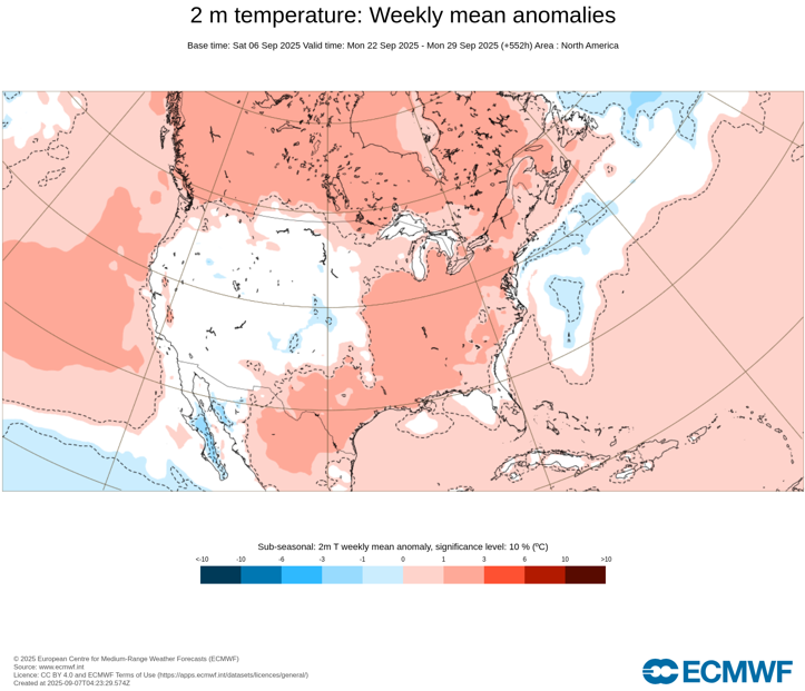
Rather warm to our North and West in the longrange Canada also very warm.
.thumb.png.52d9df277a34753f90944723423861e1.png)
-
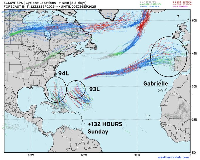
Ryan Maue @RyanMaue Hurricane Season Update | Tuesday Evening September 23, 2025 High chance of both Invest 93L & 94L developing into hurricanes with a risk to the U.S. East Coast from one of them. Major intensity on table for both --> High Uncertainty Updated ECMWF 18z cycle has Humberto and Imelda moving in concert to the NNW Highly unusual to have twin hurricanes not repelling each other or orbiting a center of mass. Uncertainty = HIGH with these two systems (currently Invest 93L and Invest 94L)
-
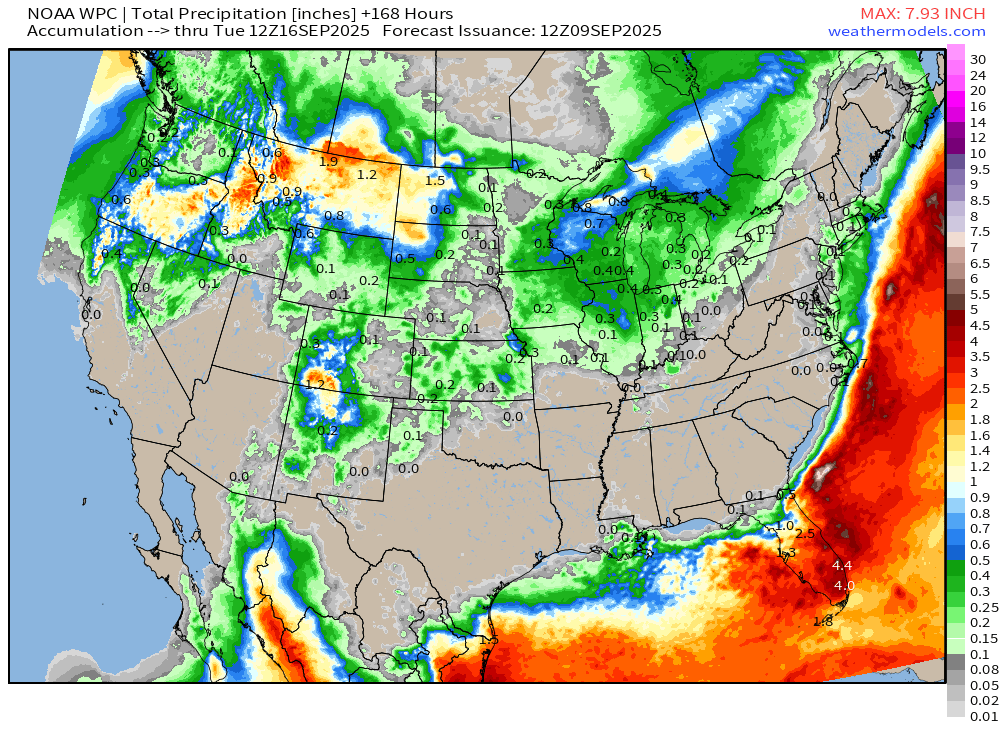
WPC seems to have cut back rainfall of total significantly with their latest afternoon update in the 7-Day. Haven't had a chance to look at the models. Do the models concur with less rainfall for our area?
-
So where is the Sun? It is almost as difficult to predict Sunshine nowadays, as it is to predict snowfall in winter. My forecast grid was for mostly sunny skies. Now I see clouds have moved in already after 1 hour of sunshine at sunrise.
-
With the upcoming weather pattern, wondering if the conditions are favorable yet for overseeding. Have you started? Currently soil temperatures in the top 0 to 10 cm are averaging 70 degrees Fahrenheit I read optimal temperatures for fescue germination is between 50 and 65° f. Long range silly guidance on the AccuWeather app shows the end of October with the first freeze of the fall, I am not sure. I believe that although the weather has been known to make dramatic, turns near Halloween
-
Mount Holly forecast has cloudy weather for 6 days in a row. How depressing
-
WPC beefing up rainfall totals with latest update. ( to a degree ) Accu-weather Philly states they doubt rain makes it this far North.
-
This is the latest from the WPC concerning this time period. Will be interesting to monitor future trends.
.gif.40a3819dc6641a83a4a12625c7daa5ec.gif)
-
It is pretty hot in the sun today
-
Today's best forecast goes to AccuWeather for my zone calling for increasing clouds in the afternoon versus the national weather service with totally sunny conditions. Clouds have moved in currently in the from Trenton to Philly to Wilmington, Delaware. Moving from Northeast to Southwest.
-
Still no significant precip
.gif.d54c288d8036d161c14a5350bd0c89c7.gif)
-
Highest heat stays West next week due to the Omega block.
.thumb.png.3d54a8e3269c0f4a93d493260e24c79c.png)
-
Rather impressive + PNA spike incoming, highest in many months.
.thumb.png.7ff8d16dc5cddce4c0a716e08a877085.png)
-
Many forecasts of mostly sunny, or even just sunny, over the past three months have ended up the opposite, sometimes the clearing was delayed until sunset.
-
Dry as a bone for a while .
-
Late month warm up seems to be a possiblity. Not unusual in Septembers that feature cool shots such as this month based on medium range modeling.
-
.66 of rain last 24 hours, can't complain. Some areas over 2.50. Feast or famine.
-
SEVERE THUNDERSTORM WATCH OUTLINE UPDATE FOR WS 607 NWS STORM PREDICTION CENTER NORMAN OK 110 PM EDT SAT SEP 6 2025 SEVERE THUNDERSTORM WATCH 607 IS IN EFFECT UNTIL 800 PM EDT FOR THE FOLLOWING LOCATIONS DEC001-003-070000- /O.NEW.KWNS.SV.A.0607.250906T1710Z-250907T0000Z/ DE . DELAWARE COUNTIES INCLUDED ARE KENT NEW CASTLE $$
-
89/70 combo currently, a forecast bust from several days ago, I already achieved 90 on the weather station. Dryness=heat.

.png.9b0c0c891337518521376dae6edf6573.png)


.png.6cf2c4bb26de106891c25d1b11e5c49a.png)
.png.0c4e00551cfa0397c834876c0f6f8a33.png)