Rjay
-
Posts
28,401 -
Joined
-
Last visited
Content Type
Profiles
Blogs
Forums
American Weather
Media Demo
Store
Gallery
Everything posted by Rjay
-
Islip reported rain the entire time but there was a bunch of white rain.
-
I don't think he was questioning it. FRG gusted to 36 mph and ISP gusted to 44 mph.
- 373 replies
-
- 1
-

-
- heavy rain
- wind event
- (and 2 more)
-
Temp back into the low 40s
-
That's mostly rain.
-
1.42" of rain here
- 373 replies
-
- 2
-

-
- heavy rain
- wind event
- (and 2 more)
-
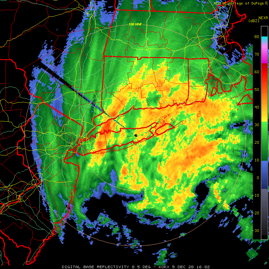
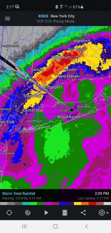
Brightbanding makes total rainfall estimates from radars useless. The red is 6" lol
-
Saved

- 373 replies
-
- 1
-
-
- heavy rain
- wind event
- (and 2 more)
-
That's pretty cool
- 373 replies
-
- 1
-
-
- heavy rain
- wind event
- (and 2 more)
-
December 2020 General Discussions & Observations Thread
Rjay replied to bluewave's topic in New York City Metro
Who's wishcasting besides the 2 Tonys? -
Lol
- 373 replies
-
- 1
-

-
- heavy rain
- wind event
- (and 2 more)
-
Busy day for @LibertyBell
-
The white rain is coming down sideways
-
37 degrees and north winds gusting to 40mph
- 373 replies
-
- 2
-
-
- heavy rain
- wind event
- (and 2 more)
-
White rain in Holbrook
- 373 replies
-
- 1
-
-
- heavy rain
- wind event
- (and 2 more)
-
New account, new country. Got it.
- 373 replies
-
- 7
-
-
- heavy rain
- wind event
- (and 2 more)
-
From Luxembourg?
- 373 replies
-
- 3
-
-
- heavy rain
- wind event
- (and 2 more)
-
Sub 1000MB sfc low and associated significant hazards Nov 30-Dec 1, 2020
Rjay replied to wdrag's topic in New York City Metro
Amityville Harbor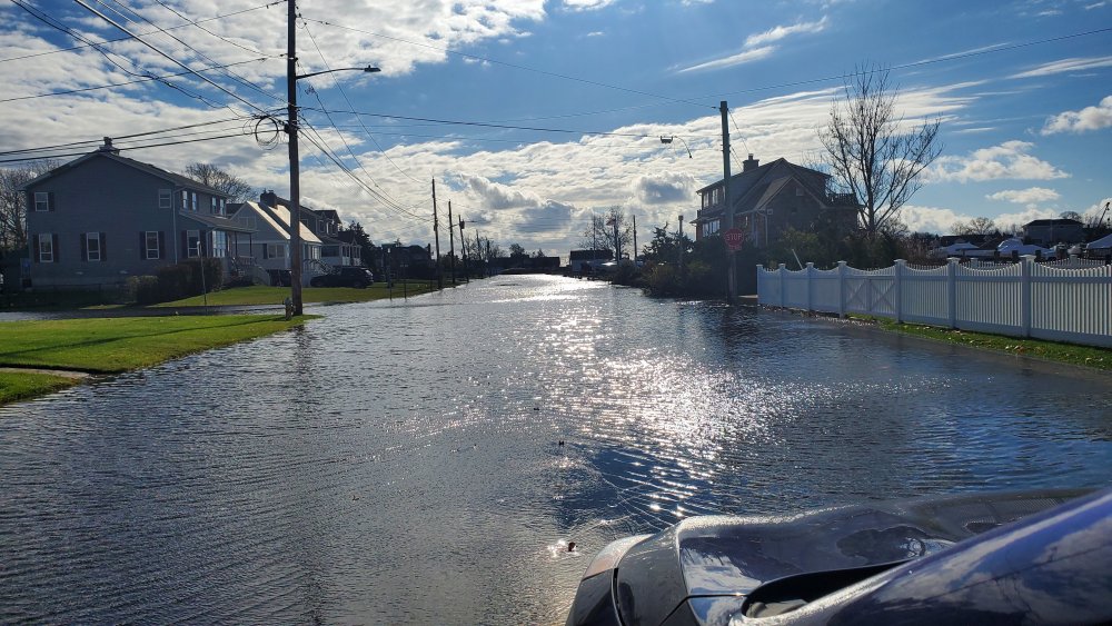
- 212 replies
-
- 4
-
-
- wind damage
- heavy rain
- (and 1 more)
-
December 2020 temperature forecast contest
Rjay replied to Roger Smith's topic in Weather Forecasting and Discussion
DCA: +1.5 NYC: +2.0 BOS: +2.5 ORD: +1.0 ATL: 0.0 IAH: 0.0 DEN: +3.0 PHX: +2.0 SEA: +1.8 -
November 2020 General Discussions & Observations Thread
Rjay replied to Rtd208's topic in New York City Metro
Great day to eat outside. I hope people take that option. -
Islip got 18" I think. Had a decent amount (6"+) in my area too. Just can't remember how much.
-
NATIONAL WEATHER SERVICE MOUNT HOLLY NJ 315 PM EST FRI MAR 02 2001 DISC: EXPLAING THE MODELS AT THIS TIME IS ANTICLIMATIC SO ILL GET RIGHT INTO THE MODEL INTERPRETATION/COORDINATION AND THE POTENTIAL EFFECTS IN OUR CWA. FIRST ORDER OF BUSINESS THIS PACKAGE IS TO ISSUE WINTER STORM WATCH FOR ENTIRE CWA FOR SUNDAY. THERE WILL BE A PERIOD OF RAIN IN THE MORNING FOR COASTAL PLAIN-COUNTIES BEFORE CHANGING OVER TO SNOW BUT THE RAPID INTENSIFICATION OFF THE N.C. COAST AND THE MAGNITUDE OF THE EVENT IN OUR CWA IS DICTATING THE EARLY WWA RELEASE ESPECIALLY WITH THE RAIN CHANGING OVER TO SNOW. ITS THE FIRST TIME THAT I CAN REMEMBER A START TIME BUT NOT AN ENDING TIME IN SIGHT. THE SNOW BEGINS IN EARNEST BY SUNDAY AFTERNOON AND CONTINUES HEAVY AT TIMES INTO MONDAY AND PERHAPS EARLY TUE. THIS STORM WILL ALSO BRING COASTAL FLOODING PROB LATE SUNDAY INTO EARLY TUE BUT THE CONCERN WILL BE FOR THE OCEAN FRONT FROM THE HEAVY WAVE ACTION AND RESULTING BEACH EROSION. AS THE STORM RAPIDLY INTENSIFIES ON SUN THE WINDS ARE GOING TO TURN TO THE NORTH BUT WITH THE PRESSURE SO LOW THE TIDES WILL STILL RISE AND PUT US IN A MODERATE TO POSSIBLY SEVERE CATEGORY ON MONDAY.
-
Weird. My phone keeps auto correcting "Thanksgiving" to "superspreader event".
-
How many people are you having at your superspreader event?