John1122
-
Posts
11,788 -
Joined
-
Last visited
Content Type
Profiles
Blogs
Forums
American Weather
Media Demo
Store
Gallery
Everything posted by John1122
-

Christmas Eve/Christmas 2020 Arctic Express Snow Obs.
John1122 replied to John1122's topic in Tennessee Valley
The DGZ is where the atmosphere reaches -10 to -20c. If there's high RH in that sector snow flakes will form. That's why snow can fall from below radar beams with the upper levels are really cold. You can even go out when it's below 0 at the surface at times and flakes will seem to form out of a clear blue sky. That's because the DGZ is very low at that point and any moisture in the air turns to snow flakes. -
Christmas Eve/Christmas 2020 Arctic Express Snow Obs.
John1122 replied to John1122's topic in Tennessee Valley
Has anyone been able to get the new dial pol precip type radar on the NWS site to work? I still have steady light to moderate snow falling. MRX posted no further accumulations the rest of the night a few minutes ago. I'm currently accumulating right now. -
Christmas Eve/Christmas 2020 Arctic Express Snow Obs.
John1122 replied to John1122's topic in Tennessee Valley
The DGZ is probably below 700mb at this point. -
Christmas Eve/Christmas 2020 Arctic Express Snow Obs.
John1122 replied to John1122's topic in Tennessee Valley
Snow actually showing up on radar over me right now. Nickel and dime flakes. Probably high end light to low end moderate snow currently. Looks a little heavier up stream, will try to monitor and compare the rates to radar depiction. -
January 2021 Medium/Longterm Pattern Discussion.
John1122 replied to AMZ8990's topic in Tennessee Valley
Haven't been looking past this storm other than the eye popping Euro run. I do see that the teleconnections are basically perfect the first several days of January. Super negative AO. Moderately negative NAO. Somewhat positive PNA. Those scream cold and winter storms here. Heck, I'm already close to 7 inches for the season and it's only December 24th. Barring a massive collapse (which is highly possible) I may get my average of around 16-17inches. Though lately I either have a 20-30+ inch season or I have 5 or 6 inch seasons. -
Christmas Eve/Christmas 2020 Arctic Express Snow Obs.
John1122 replied to John1122's topic in Tennessee Valley
No telling where they will end up. But the HRRR continues to put down 2 to 3 inch streaks where it trains them each run. They are never in exactly the same place two runs in a row but give you a good idea of what can happen. -
Christmas Eve/Christmas 2020 Arctic Express Snow Obs.
John1122 replied to John1122's topic in Tennessee Valley
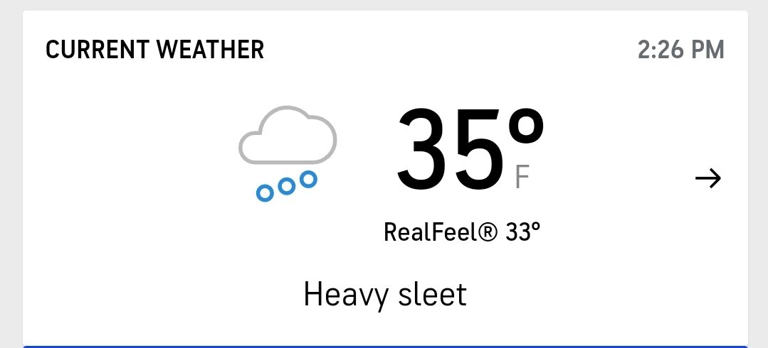
The heavy sleet here laid down a layer of ice in the roads that quickly got topped by heavy snow. Multiple wrecks on I-75. Took my friend's wife almost 3 hours to get from north Knox to Jacksboro. Normally a 40 miunute trip. The heavy rain that prevented any pre-treating was bad news. -
Dandridge Dollop 12/24/20 Storm Thread (Winter Wonderland)
John1122 replied to AMZ8990's topic in Tennessee Valley
HRRR and RAP likes a little band over Cumberland, Fentress and Morgan co. Shows 2-4 more inches there by tomorrow. These bands will be high ratio and should stack up overnight to the tune of an inch or two at least if anyone can get them to train over your back yard. It's currently 23 here and I'm sure will will fall into the 10s as these bands rotate through over night. HRRR even has my area getting another 1 to 1.5 inches. WVLT even had a secondary snow spike tomorrow evening around 4 in Knoxville. They have a it 20 percent snow during the day then 40 in the afternoon. He seems to use the HRRR himself. Or their house model is based on it.- 847 replies
-
- 6
-

-
- cold temperatures
- snow
- (and 8 more)
-
Christmas Eve/Christmas 2020 Arctic Express Snow Obs.
John1122 replied to John1122's topic in Tennessee Valley
It may take until tomorrow, but the HRRR has a little Bulleye in NW Cumberland that picks up close to 4 inches from the streamers. -
Christmas Eve/Christmas 2020 Arctic Express Snow Obs.
John1122 replied to John1122's topic in Tennessee Valley
Cousins at 2800ft, 6 inches. They had 1.5 inches down when I changed from sleet to snow. -
Christmas Eve/Christmas 2020 Arctic Express Snow Obs.
John1122 replied to John1122's topic in Tennessee Valley
A few photos from around here before dark. -
Christmas Eve/Christmas 2020 Arctic Express Snow Obs.
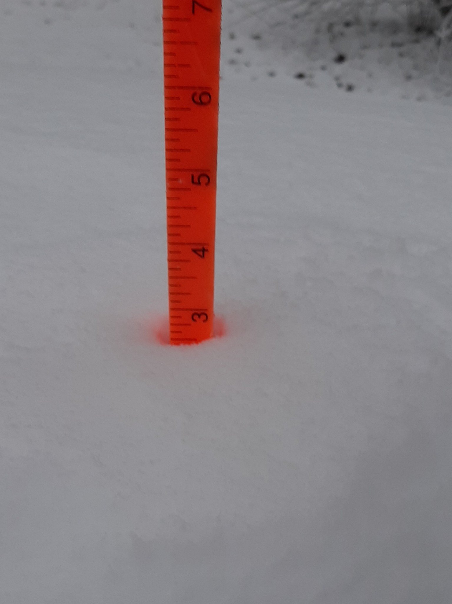
John1122 replied to John1122's topic in Tennessee Valley
Finally down to flurries here. About 3.75 inches. Banding snow West of the Plateau, possibly even on it but Fentress is a radar black hole. -
Christmas Eve/Christmas 2020 Arctic Express Snow Obs.
John1122 replied to John1122's topic in Tennessee Valley
Not gonna go full RGEM but it beat the Euro/UKiE/NAM imby. -
Christmas Eve/Christmas 2020 Arctic Express Snow Obs.
John1122 replied to John1122's topic in Tennessee Valley
3.5 inches down. Steady snow still falling. TDOT reporting traffic nightmares in Campbell on I-75 due to heavy snow. -
Christmas Eve/Christmas 2020 Arctic Express Snow Obs.
John1122 replied to John1122's topic in Tennessee Valley
Don't know why the picture won't upload. About 45 minutes ago.
-
Christmas Eve/Christmas 2020 Arctic Express Snow Obs.
John1122 replied to John1122's topic in Tennessee Valley
2.5 inches down. Fine flakes but very low visibility here. -
Christmas Eve/Christmas 2020 Arctic Express Snow Obs.
John1122 replied to John1122's topic in Tennessee Valley
Flake size has dropped with crashing temps in the upper levels but visibility is still around 1/4th mile or less. That initial sleet and then huge flakes helped the laying process greatly. Plus the very low late December sun angle and decently cold temps and even the rain cooling the ground. That's why I questioned JKL saying it would take a while to start laying a few days ago. -
Christmas Eve/Christmas 2020 Arctic Express Snow Obs.
John1122 replied to John1122's topic in Tennessee Valley
Birds in the snow.- 409 replies
-
- 13
-
-
Christmas Eve/Christmas 2020 Arctic Express Snow Obs.
John1122 replied to John1122's topic in Tennessee Valley
I'm about to officially reach white Christmas status. Closing in on an inch already. Currently visibility is approximately 700 feet. I think I may bust high on the MRX call map if I can maintain this for even another hour. Not counting and potential banding or anything like that. -
Christmas Eve/Christmas 2020 Arctic Express Snow Obs.
John1122 replied to John1122's topic in Tennessee Valley
I am sure areas to the East will do much better but it's hard to beat getting to see these huge flakes falling while red birds fill the apple tree by my feeder in the daylight. Daylight snow is just rare here any more. -
Christmas Eve/Christmas 2020 Arctic Express Snow Obs.
John1122 replied to John1122's topic in Tennessee Valley
Ripping half and silver dollars now. Or fatties as some would say. -
Christmas Eve/Christmas 2020 Arctic Express Snow Obs.
John1122 replied to John1122's topic in Tennessee Valley
35 to 34 did it for Jacksboro.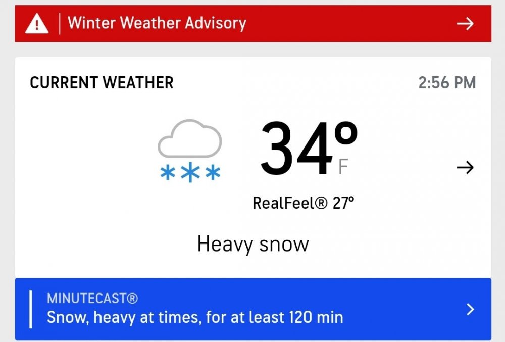
-
Christmas Eve/Christmas 2020 Arctic Express Snow Obs.
John1122 replied to John1122's topic in Tennessee Valley
32 and the ground is milky white. Large snow flakes with probably 5 percent sleet. Just enough to barely hear it. -
Christmas Eve/Christmas 2020 Arctic Express Snow Obs.
John1122 replied to John1122's topic in Tennessee Valley
Just turned the corner. Heavy snow now. Quarter to half dollar sized flakes. -
Christmas Eve/Christmas 2020 Arctic Express Snow Obs.
John1122 replied to John1122's topic in Tennessee Valley
Obs from Jacksboro to my South.