Tyler Penland
-
Posts
2,520 -
Joined
-
Last visited
Content Type
Profiles
Blogs
Forums
American Weather
Media Demo
Store
Gallery
Everything posted by Tyler Penland
-

2020 Spring and Summer mountain thread.
Tyler Penland replied to Met1985's topic in Southeastern States
Yeah it's dropping quick. Down to 46 here in foscoe. Was 55 just a bit ago. -
2020 Spring and Summer mountain thread.
Tyler Penland replied to Met1985's topic in Southeastern States
Wind really picking up here at the house again. -
2020 Spring and Summer mountain thread.
Tyler Penland replied to Met1985's topic in Southeastern States
Wind is rocking here in foscoe. We're well protected from the northwest flow wind most of the time but the angle of this valley funnels in the south/west stuff. -
2020 Spring and Summer mountain thread.
Tyler Penland replied to Met1985's topic in Southeastern States
Dusting in Boone this morning on raised surfaces. -
2020 Spring and Summer mountain thread.
Tyler Penland replied to Met1985's topic in Southeastern States
Snow on Sugar now. Not sure if it'll drop low enough for us here at the house but banner elk should be in good shape. -
2020 Spring and Summer mountain thread.
Tyler Penland replied to Met1985's topic in Southeastern States
Snowing on Beech already per FB video. Webcams appear to be down. -
2020 Spring and Summer mountain thread.
Tyler Penland replied to Met1985's topic in Southeastern States
NAM is really intent on that (deform-ish?) band this evening laying down snow at elevation. Tries to work it down into Boone too around 0z. Where was this when it was cold? -
December 8-10, 2018 Winter Storm
Tyler Penland replied to Orangeburgwx's topic in Southeastern States
I'd go with spruce pine. Better infrastructure to power back or get out. There ain't nothing out around Sparta lol. -
December 8-10, 2018 Winter Storm
Tyler Penland replied to Orangeburgwx's topic in Southeastern States
Didn't see anybody else post these. Still a lot of solutions on the table. Sent from my SM-G960U using Tapatalk -
It's rained a TON in WNC this summer. Boone area just had flash flooding last night. Sent from my SM-G960U using Tapatalk
-
Right now pretty much every model dumps on WNC. Sent from my SM-G960U using Tapatalk
-
Looks like 4-6+ on the TT maps for the FV3, but that would almost definitely be underdone in the SE facing escarpment areas. Strong, moist SE flow is the last thing you want to see and I wouldn't be surprised for some areas to see a foot or more. Only good news is that it's actually moving by then instead of just crawling.
-
FWIW They were fairly accurate for NE GA during Irma but that's the only time I've used them much. Probably a touch overdone but no surprise there.
-
Crazy stuff.
-
Southeast Sanitarium - A Place to Vent
Tyler Penland replied to Jonathan's topic in Southeastern States
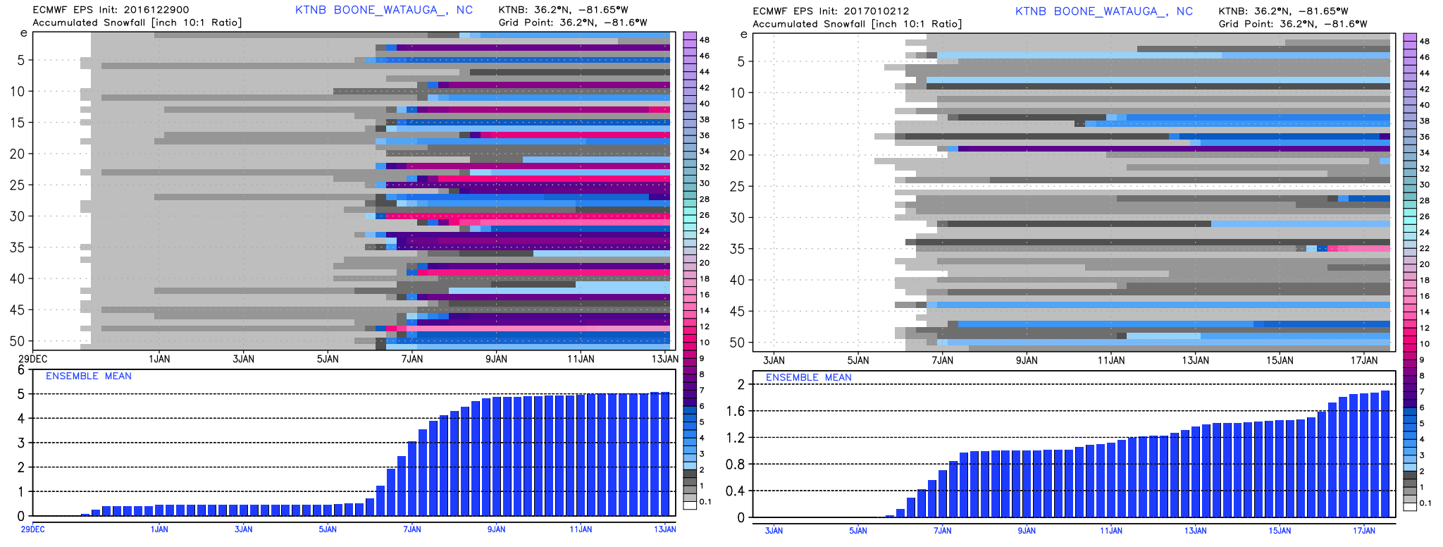
This has been a depressing collapse to watch up here. EPS from the 29th vs today.
-
Weather References and Newbie Information
Tyler Penland replied to burgertime's topic in Southeastern States
I use www.pivotalweather.com for point soundings from time to time. Geared more towards severe weather IMO, though. If you are dedicated and don't mind a small learning curve, BUFKIT is fantastic for viewing model sounds from the NAM/GFS. http://www.wdtb.noaa.gov/tools/BUFKIT/ Once you download the program the data distribution is here: http://www.meteo.psu.edu/bufkit/CONUS_NAM_00.html