Tyler Penland
-
Posts
2,523 -
Joined
-
Last visited
Content Type
Profiles
Blogs
Forums
American Weather
Media Demo
Store
Gallery
Everything posted by Tyler Penland
-

2026 Spring/Summer Mountain Thread
Tyler Penland replied to Buckethead's topic in Southeastern States
Aight one day of heat back and I'm already over it. Bring on fall/winter. Heading to the North Wilkesboro races this weekend and the trucks are at 12:30 on Saturday afternoon. -
2026 Spring/Summer Mountain Thread
Tyler Penland replied to Buckethead's topic in Southeastern States
My station made it to 90.5 this afternoon. As far as I can remember that's the first time I've ever recorded a high above 90 here at the house. Yesterday was 89.3. Sent from my Pixel 10 Pro using Tapatalk -
2026 Spring/Summer Mountain Thread
Tyler Penland replied to Buckethead's topic in Southeastern States
We managed to hit 42.1º this morning. Much cooler than I expected. The station right below me directly on the river hit 40.3º. Wild. I was hiking up at Grayson Highlands yesterday and it was in the mid-40s all evening. Definitely an odd, but very nice day out for early June. -
2026 Spring/Summer Mountain Thread
Tyler Penland replied to Buckethead's topic in Southeastern States
Only dropped to 35.6º last night. My wife's raised bed vegetables are thankful. -
2026 Spring/Summer Mountain Thread
Tyler Penland replied to Buckethead's topic in Southeastern States
Low of 31.6º this morning. Been enjoying the cool temps. Looks like finally some legitimate rain this weekend- we need some or spring flower season is going to suck. -
2026 Spring/Summer Mountain Thread
Tyler Penland replied to Buckethead's topic in Southeastern States
0.06" overnight- bottomed out at 37º this morning. Saw some reports of flurries around but never saw any myself here at the house. -
2026 Spring/Summer Mountain Thread
Tyler Penland replied to Buckethead's topic in Southeastern States
I managed a grand total of 0.01" overnight last night. Just enough to make the truck look even worse dirty. -
2025-2026 Fall/Winter Mountain Thread
Tyler Penland replied to Buckethead's topic in Southeastern States
Hard to argue with how this winter went, although I certainly would've liked to have seen more than 5" at a time. I ended the year with right at 20", pretty solid and right on average. I've seen plenty of below-average winters since moving up here so an average year is a win for me. That absolutely gorgeous December snow also gives a boost. -
2025-2026 Fall/Winter Mountain Thread
Tyler Penland replied to Buckethead's topic in Southeastern States
Just rolled into Daytona, heading down for the (hopeful) Artemis launch tomorrow. I always, and I mean every single time, forget how miserable the humidity is once you get south of the NC line. Brutal. -
2025-2026 Fall/Winter Mountain Thread
Tyler Penland replied to Buckethead's topic in Southeastern States
We must've gotten under a nice band overnight because I went to bed at 1/2" and woke up to a solid 3". Very nice surprise! -
2025-2026 Fall/Winter Mountain Thread
Tyler Penland replied to Buckethead's topic in Southeastern States
Starting to cover the grass here in Blowing Rock now. Took forever to switch over but hammering now. -
2025-2026 Fall/Winter Mountain Thread
Tyler Penland replied to Buckethead's topic in Southeastern States
Webcams show switch to snow in Boone. Still rain here in Blowing Rock but I suspect for not much longer -
2025-2026 Fall/Winter Mountain Thread
Tyler Penland replied to Buckethead's topic in Southeastern States
Huge temp crash in Blowing Rock, down 10 degrees in the last 12 minutes. -
2025-2026 Fall/Winter Mountain Thread
Tyler Penland replied to Buckethead's topic in Southeastern States
The temperature trace in Franklin since 2AM is really something. From 55 to 35.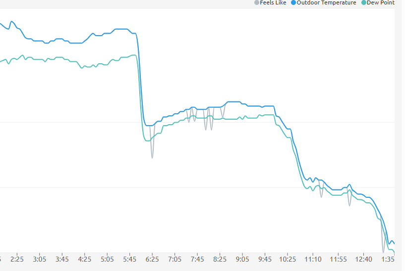
-
2025-2026 Fall/Winter Mountain Thread
Tyler Penland replied to Buckethead's topic in Southeastern States
Wind absolutely howling this evening. Fun 24 hours ahead no doubt. Sent from my Pixel 10 Pro using Tapatalk -
2025-2026 Fall/Winter Mountain Thread
Tyler Penland replied to Buckethead's topic in Southeastern States
Got a couple confirmed reports of snow in the North Georgia mountains even around Suches. -
2025-2026 Fall/Winter Mountain Thread
Tyler Penland replied to Buckethead's topic in Southeastern States
Been coming down hard in Blowing Rock since about 10. Good dusting on the grass now and WINDY. Sounds like a jet on our roof at times. Sent from my Pixel 10 Pro using Tapatalk -
2025-2026 Fall/Winter Mountain Thread
Tyler Penland replied to Buckethead's topic in Southeastern States
18z 3km NAM was on board with the light icing across the NW mountains on Monday. 0z running now. Shouldn't be anything significant but a little glaze along the escarpment possible. Big difference to the beautiful weather today. -
2025-2026 Fall/Winter Mountain Thread
Tyler Penland replied to Buckethead's topic in Southeastern States
18z GFS is a pretty widespread CAD event. Definitely an interesting pattern with the wedge in place. -
2025-2026 Fall/Winter Mountain Thread
Tyler Penland replied to Buckethead's topic in Southeastern States
Naturally I am down in Georgia with snow up there for the third straight trip. Wife measured 3.5" on the board though, solid storm. Headed back up this afternoon hopefully roads are clearer. Sent from my Pixel 10 Pro using Tapatalk -
2025-2026 Fall/Winter Mountain Thread
Tyler Penland replied to Buckethead's topic in Southeastern States
Well, I guess the HRRR was only mostly out to lunch. Sweet- it was the only model that even had that possible. -
2025-2026 Fall/Winter Mountain Thread
Tyler Penland replied to Buckethead's topic in Southeastern States
It is probably completely out to lunch, but the HRRR is very, very close to snow along the escarpment as the low moves through Sunday..thumb.png.2d9c6eca4e4142c33497b494768cded5.png)
-
2025-2026 Fall/Winter Mountain Thread
Tyler Penland replied to Buckethead's topic in Southeastern States
Ha fair point. I'm not sure if Boone really qualifies as having "things" but the map does look pretty spot on for my area of the county at least. Seven Devils would be a good option- I live in Foscoe just down from it and the upper end towards Hawks Nest does really, really well. The Tynecastle/Banner Elk area as a whole is pretty solid with a pretty big drop-off towards Valle Crucis to the north and Linville to the south. Obviously Beech is fantastic but the trek up and down can get annoying. -
2025-2026 Fall/Winter Mountain Thread
Tyler Penland replied to Buckethead's topic in Southeastern States
Just move in next to Buckethead. Save yourself a lot of analysis LOL Sent from my Pixel 10 Pro using Tapatalk -
2025-2026 Fall/Winter Mountain Thread
Tyler Penland replied to Buckethead's topic in Southeastern States
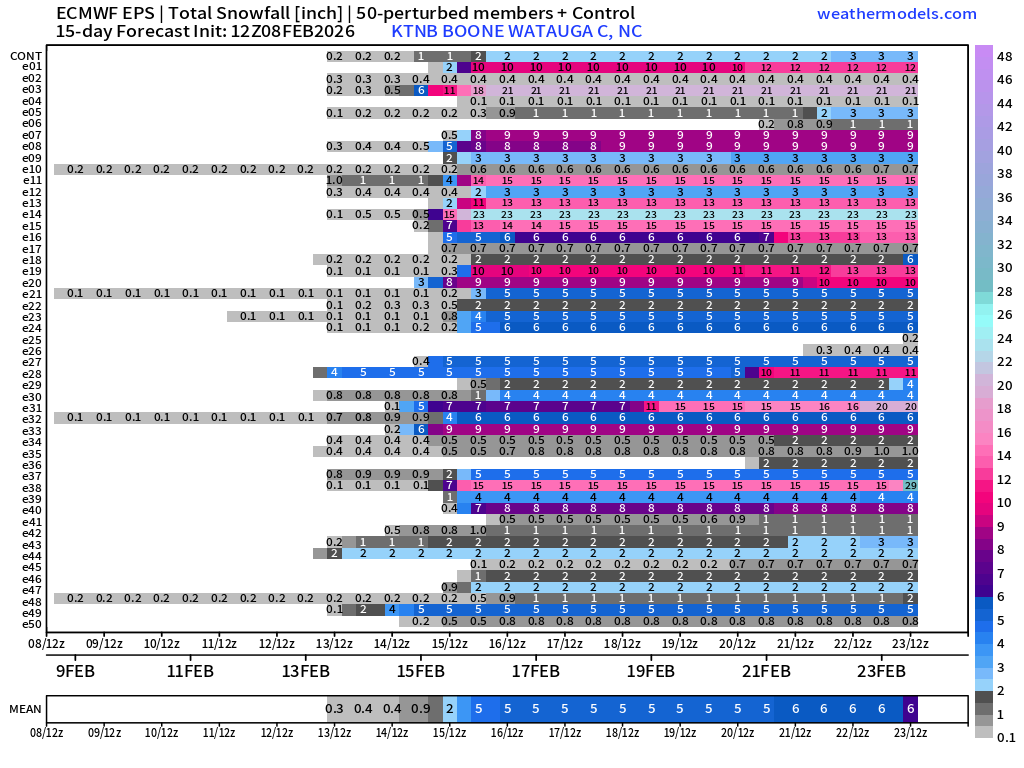
Don't look now, but....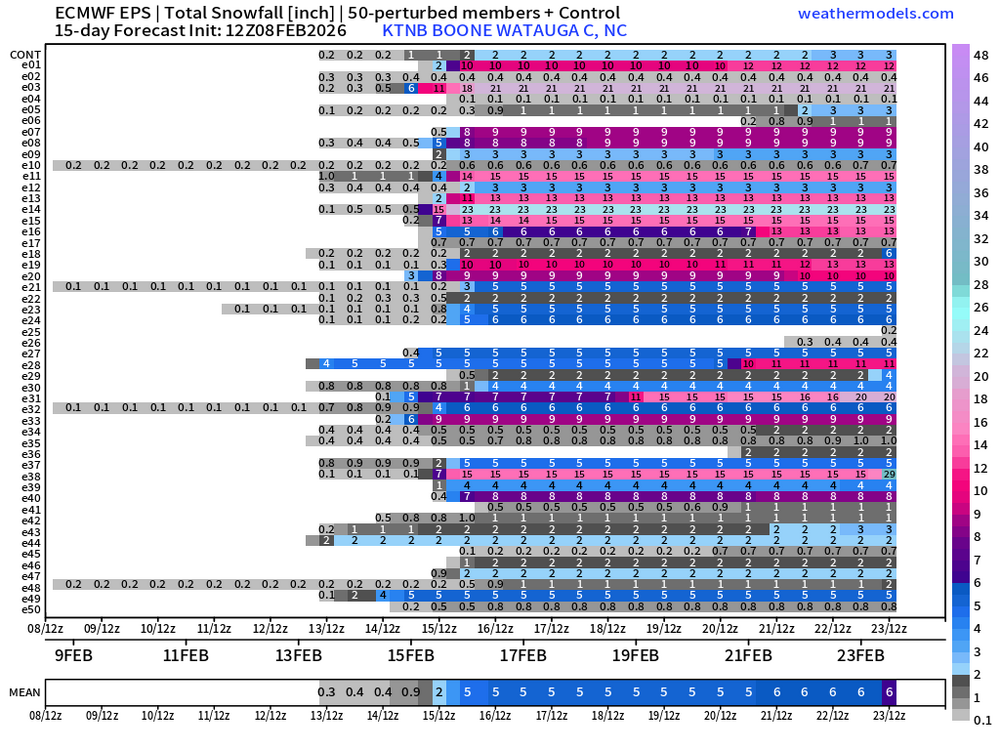

.png.9eb13f0cd4c13a17f6328e4ad2059322.png)