Tyler Penland
-
Posts
2,523 -
Joined
-
Last visited
Content Type
Profiles
Blogs
Forums
American Weather
Media Demo
Store
Gallery
Everything posted by Tyler Penland
-

2025-2026 Fall/Winter Mountain Thread
Tyler Penland replied to Buckethead's topic in Southeastern States
Right at 2" here at the house. NAM really keying in on the little shortwave tomorrow across the Northern Mountains again.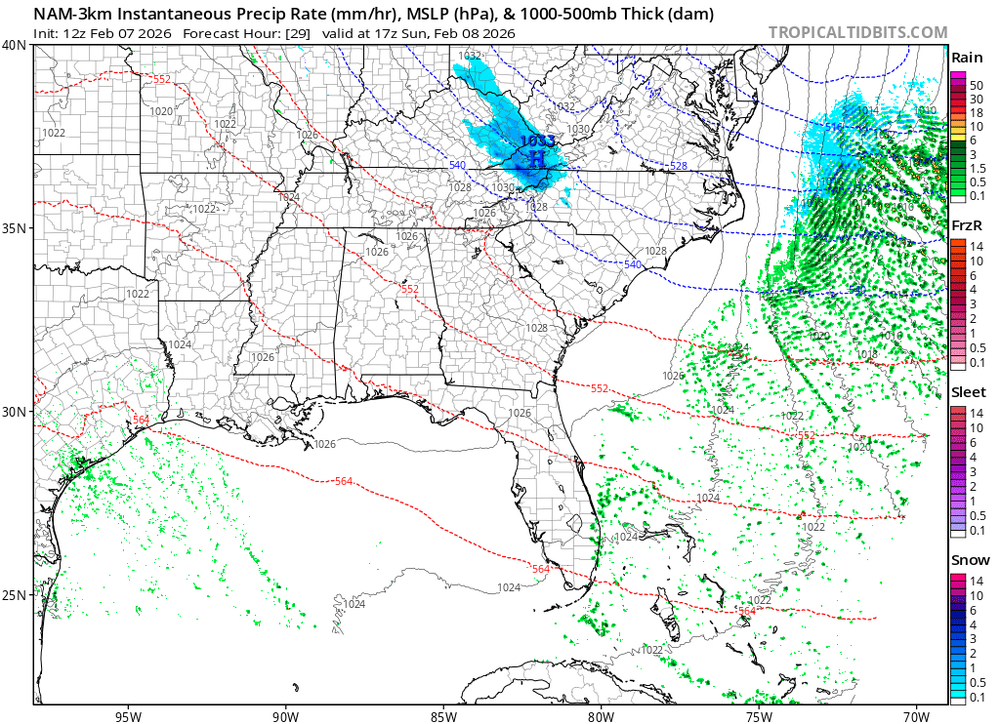
-
2025-2026 Fall/Winter Mountain Thread
Tyler Penland replied to Buckethead's topic in Southeastern States
Yeah not bad. Can hear a few gusts up the hill now. Interestingly our power flickered earlier but its been dead calm ever since. Considering making my annual freeze-my-butt-off trip to Grayson Highlands tomorrow. Always a fun adventure consisting of trying not to freeze while also remaining upright. -
2025-2026 Fall/Winter Mountain Thread
Tyler Penland replied to Buckethead's topic in Southeastern States
Very underwhelming here so far- hopefully we see it pick up soon but currently on 29.7 with a dusting from the first round. Very little precip since then, even the Beech Mt cams look like not much going on besides some clouds. -
2025-2026 Fall/Winter Mountain Thread
Tyler Penland replied to Buckethead's topic in Southeastern States
Absolutely dumped here in Blowing Rock for a while. It's calmed down now, waiting for the NWF to kick in. Winds are still mostly calm although I suspect that will change shortly. -
2025-2026 Fall/Winter Mountain Thread
Tyler Penland replied to Buckethead's topic in Southeastern States
Yep here she comes. -
2025-2026 Fall/Winter Mountain Thread
Tyler Penland replied to Buckethead's topic in Southeastern States
Yeah, especially the CCTI side of town. The bypass area always scores during these type systems. Can see some wide variance from the bypass towards Deep Gap but the NAM has pretty deep moisture for a while tomorrow afternoon/night.
-
2025-2026 Fall/Winter Mountain Thread
Tyler Penland replied to Buckethead's topic in Southeastern States
I've said this a few times this year and I've yet to see any, but once again the 3km NAM looks convective with that initial band tomorrow. At some point one of us has to get lucky with some T-snow. Otherwise this looks spectacular. Outside chance I actually get more from this than I did last weekend. We only ended with 5" last weekend, and NAM supports 6-8" at the house. Flow direction is pretty good for me. Banner Elk should definitely be a hotspot this time. -
2025-2026 Fall/Winter Mountain Thread
Tyler Penland replied to Buckethead's topic in Southeastern States
Dumping snow here in Blowing Rock now Sent from my Pixel 10 Pro using Tapatalk -
2025-2026 Fall/Winter Mountain Thread
Tyler Penland replied to Buckethead's topic in Southeastern States
Should be some really pretty wet/sticky stuff on top of that. Then NWFS on Friday night. If the snow lingers past midnight there's a chance we could have frozen precip every single day this week except this coming Sunday. -
2025-2026 Fall/Winter Mountain Thread
Tyler Penland replied to Buckethead's topic in Southeastern States
Technically currently have ZR at the house. Air temp is 31.8 with light rain. Sent from my Pixel 10 Pro using Tapatalk -
2025-2026 Fall/Winter Mountain Thread
Tyler Penland replied to Buckethead's topic in Southeastern States
Yeah little secondary low popping along the front. Interesting little setup. Then NWFS over the weekend. I just need it to be nice in Florida if the Artemis II launch goes on schedule. Sent from my Pixel 10 Pro using Tapatalk -
2025-2026 Fall/Winter Mountain Thread
Tyler Penland replied to Buckethead's topic in Southeastern States
We've officially got snow flurries falling in Blowing Rock. Little but showing on radar even. Just straight up light snow now. Sent from my Pixel 10 Pro using Tapatalk -
2025-2026 Fall/Winter Mountain Thread
Tyler Penland replied to Buckethead's topic in Southeastern States
Down to 6 already. Air temp falling fast. Sent from my Pixel 10 Pro using Tapatalk -
2025-2026 Fall/Winter Mountain Thread
Tyler Penland replied to Buckethead's topic in Southeastern States
We're gonna end with 5" after some compaction this afternoon. Bring on the NWFS overnight- can already hear the wind picking up and we just dropped to 9º. -
2025-2026 Fall/Winter Mountain Thread
Tyler Penland replied to Buckethead's topic in Southeastern States
Up to 4". You guys in the south mountains are crushing it. Congrats! WV looks very healthy back into TN, should keep going for a while.
-
2025-2026 Fall/Winter Mountain Thread
Tyler Penland replied to Buckethead's topic in Southeastern States
We're at 3" here in Foscoe. Coming down at a good clip currently but took a while to get going overnight. -
2025-2026 Fall/Winter Mountain Thread
Tyler Penland replied to Buckethead's topic in Southeastern States
HRRR is handling this pretty well. Should really start cranking between midnight and sunrise. -
2025-2026 Fall/Winter Mountain Thread
Tyler Penland replied to Buckethead's topic in Southeastern States
Dang guys slow down LOL. We're just at a dusting here but finally picking up. -
2025-2026 Fall/Winter Mountain Thread
Tyler Penland replied to Buckethead's topic in Southeastern States
It's currently mostly clear and sprinkling (??) in Blowing Rock. Very weird, the sprinkles not the clear. It feels very humid so maybe it's condensing right above the ground? I saw a couple drops hit my jacket otherwise I'd have dismissed it.' edit: after the drive home definitely a diamond dust kind of situation just with temps in the upper-20s. Was snow on the other end of Schulls Mill over at Foscoe. Sent from my Pixel 10 Pro using Tapatalk -
2025-2026 Fall/Winter Mountain Thread
Tyler Penland replied to Buckethead's topic in Southeastern States
Here's the whole run. Up to nearly a foot for Boone now. -
2025-2026 Fall/Winter Mountain Thread
Tyler Penland replied to Buckethead's topic in Southeastern States
Interestingly nothing in Blowing Rock yet. Reckon it is sticking close to the border for now. -
2025-2026 Fall/Winter Mountain Thread
Tyler Penland replied to Buckethead's topic in Southeastern States
Just heard snow has started in Banner Elk. Here we go.... -
2025-2026 Fall/Winter Mountain Thread
Tyler Penland replied to Buckethead's topic in Southeastern States
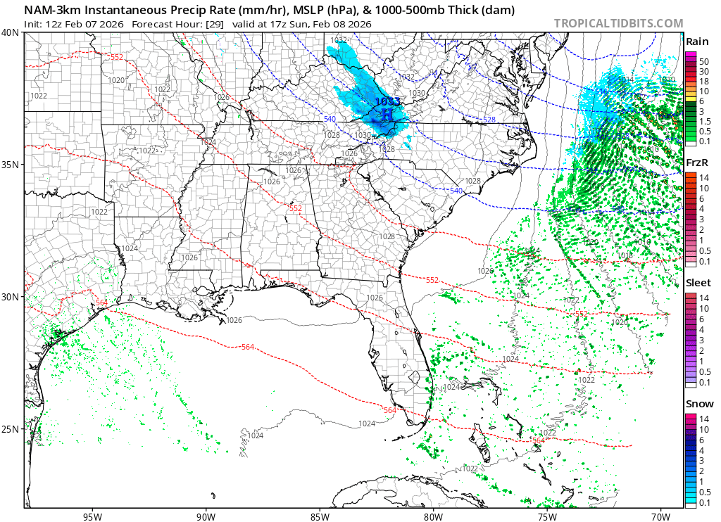
Kinda lost in all this but there is a very real chance Charleston sets their all time low 500mb heights with this storm. NAM drops to 522dam their current record is 527dam from 12/13/2010. -
2025-2026 Fall/Winter Mountain Thread
Tyler Penland replied to Buckethead's topic in Southeastern States
So... Saturday and Sunday. Got it. LOL The Warning alone has that criteria in it- 4-7" of snow plus sustained 35, gusts to 60. From the AFD That said, conditions will remain hazardous due to the amount of wind that is being forecast. As the storm deepens along the coast expected winds to increase areawide Saturday night into Sunday with wind gusts ranging from 40 mph in the piedmont to as much as 60 mph across the mountain ridges. This will result in considerable blowing and drifting snow. All of the snow that falls will be falling on a layer of ice (the compacted snow and sleet of the previous storm). Due to the lack of friction, all of the new snow will become available to blow with the wind... which means there will be a lot of drifting and roads being inundated from wind swept snow. -
2025-2026 Fall/Winter Mountain Thread
Tyler Penland replied to Buckethead's topic in Southeastern States
Anybody know what Blacksburg's requirements for a Blizzard Warning are? With the wind/rates/white out conditions under the ULL I could see those being reached.