

weatherwiz
-
Posts
81,139 -
Joined
-
Last visited
Content Type
Profiles
Blogs
Forums
American Weather
Media Demo
Store
Gallery
Everything posted by weatherwiz
-

26th-27th event, coming at us like a wounded duck.
weatherwiz replied to Go Kart Mozart's topic in New England
The good news is I think everyone here who is in line to potentially be impacted by the band has realistic expectations. I think there is solid agreement on the max swath somewhere in the 4-8/6-10 range. -
26th-27th event, coming at us like a wounded duck.
weatherwiz replied to Go Kart Mozart's topic in New England
I would do it right at the table. Hell, I may bring my laptop and an additional monitor and toss the food onto the floor and setup shop on the table -
26th-27th event, coming at us like a wounded duck.
weatherwiz replied to Go Kart Mozart's topic in New England
Weakens a bit crossing CT but this would lead to a helluva dump. It just sucks this is going to be in and out. But I am feeling confident much of the state will get 4-8 inches. My map yesterday looks very stupid now. I think the ranges with this will have to be a bit larger than usual because of the cutoff that will occur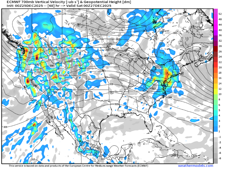
-
26th-27th event, coming at us like a wounded duck.
weatherwiz replied to Go Kart Mozart's topic in New England
Euro may be a bit more northeast too...tough to tell but regardless looks pretty solid for much of CT with a quick glance -
26th-27th event, coming at us like a wounded duck.
weatherwiz replied to Go Kart Mozart's topic in New England
No disagreement there. The uncertainty is definitely there, particularly moving northeast of Fairfield County. Here is HREF probability for 1"+ per hour rates. Right on the border getting into Hartford and eastern half of New Haven County. I guess it may just come down to how confident the forecaster is in meeting warning criteria. -
26th-27th event, coming at us like a wounded duck.
weatherwiz replied to Go Kart Mozart's topic in New England
We should saturate quickly but this will be a concern along the fringes of the precipitation shield. The bigger concern with dry air IMO is how quickly does dry air filter in aloft...that is going to cut down the banding very quickly. This is one of the reasons I think its just a 3 hour or so period of very heavy snowfall and why I think max totals will be 6-8" versus something like 9-10" or 9-12" -
26th-27th event, coming at us like a wounded duck.
weatherwiz replied to Go Kart Mozart's topic in New England
I'm also factoring in holiday travel. Winter Storm Watches certainly raises awareness but you figure alot of people will probably be wanting to adjust plans today. In a normal scenario I think it would be watches then warnings tonight but holiday travel may factor into the decision making. -
26th-27th event, coming at us like a wounded duck.
weatherwiz replied to Go Kart Mozart's topic in New England
Depending on how the euro swings, I wonder if we could even go straight to Winter Storm Warnings -
26th-27th event, coming at us like a wounded duck.
weatherwiz replied to Go Kart Mozart's topic in New England
I would certainly hold off traveling Saturday morning, where to in PA? -
26th-27th event, coming at us like a wounded duck.
weatherwiz replied to Go Kart Mozart's topic in New England
any changes/adjustments would mostly likely come with the afternoon package and I doubt any significant changes would be made until after assessing the Euro too. This is a very delicate situation, we've been burned before shooting the moon with these amped solutions only for things to trend down a bit as we got closer. The trends have been great for our region, but there are still lots of uncertainties and flags to consider, particularly when determining what and where the max swath will be. This is probably something we can't even pin down until nowcasting time. @Sey-Mour Snow thoughts several posts up I think sum this up extremely well with a sharp cutoff away from the strip -
26th-27th event, coming at us like a wounded duck.
weatherwiz replied to Go Kart Mozart's topic in New England
meh get your shit together -
26th-27th event, coming at us like a wounded duck.
weatherwiz replied to Go Kart Mozart's topic in New England
these certainly typically have two max areas. I like your idea of BGM to BDR for the main max zone. Hell, you can even see that on the GFS too -
26th-27th event, coming at us like a wounded duck.
weatherwiz replied to Go Kart Mozart's topic in New England
Ultimately I think you're in a great spot...and kudos to those who have mentioned that to you over the past day or two. I thought the hope was low for such a big bump northeast, but alas here we are. There are still lots of uncertainties with this, but that is going to make for a fun (but stressful) forecast. -
26th-27th event, coming at us like a wounded duck.
weatherwiz replied to Go Kart Mozart's topic in New England
You know what's going through the mind right now...what if the banding actually occurs even farther north then what guidance has (which we know is something that is rather common)...that could essentially put like along or south of the MA Pike through BDL and kevin into the jackpot zone lol -
26th-27th event, coming at us like a wounded duck.
weatherwiz replied to Go Kart Mozart's topic in New England
yup...damn trees and hills and valleys wrecking havoc on the radar beams. If I ever won a billion dollar powerball (well I would have to play the lotto first) I would pay to have a radar installed at BDL -
26th-27th event, coming at us like a wounded duck.
weatherwiz replied to Go Kart Mozart's topic in New England
I would have to think we see winter storm watches expanded through much of CT...maybe the trigger is pulled for a warning in Fairfield? -
26th-27th event, coming at us like a wounded duck.
weatherwiz replied to Go Kart Mozart's topic in New England
It's fairly unstable too into the DGZ. That could certainly argue for some rates locally approaching 3"/hr but I don't think those rates would be sustained for a full hour or multiple hours. Such a tough forecast...you almost have to have a large swath of something like 5-8" or 6-9" and then just use text to emphasize that swath ma be a bit more narrow as those totals are highly dependent on where the banding occurs and how wide the banding is. -
26th-27th event, coming at us like a wounded duck.
weatherwiz replied to Go Kart Mozart's topic in New England
NAM bufkit is out! So far looked at a couple locations (Waterbury and New Haven with New Haven shown below). Beautiful crosshair signature for a good 3 hours. But note...the duration of the snow, particularly the heaviest snow is going to be short lived. This is something that is going to cut back on the upper ceiling with this. It could really be difficult to pull off more than 6-7" but there are many factors to consider here. NAM bufkit even looks solid through Hartford. But it should be stressed that this is solely tied into the banding...meaning if you are not under the banding, its probably going to suck and may be difficult to accumulate more than a few inches (though most should be happy with that).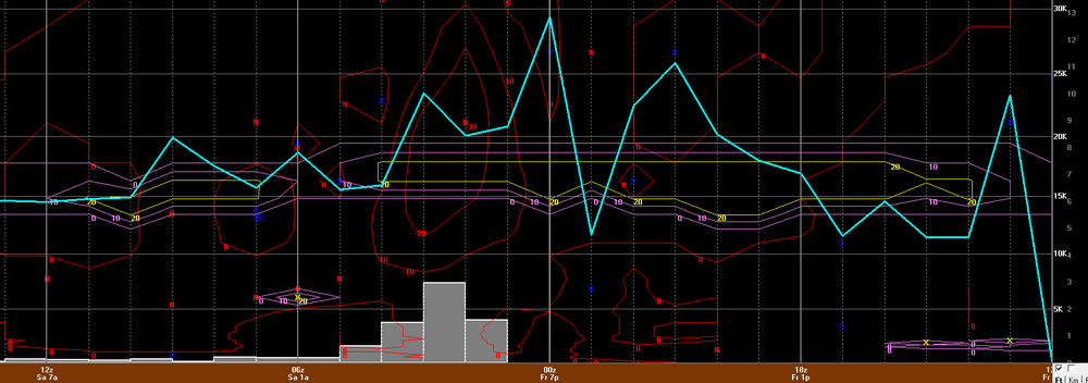
-
26th-27th event, coming at us like a wounded duck.
weatherwiz replied to Go Kart Mozart's topic in New England
2014-2015 winter? That might be what I am thinking of then. -
26th-27th event, coming at us like a wounded duck.
weatherwiz replied to Go Kart Mozart's topic in New England
Early 2010's? Edit: Maybe 2013 or 2014? -
26th-27th event, coming at us like a wounded duck.
weatherwiz replied to Go Kart Mozart's topic in New England
Is the NAM starting to pick up on where that fronto band will traverse? But you can see with this one...its essentially where that fronto band occurs. Outside of that band precip is pretty meager. The cutoff is going to be wild -
26th-27th event, coming at us like a wounded duck.
weatherwiz replied to Go Kart Mozart's topic in New England
NAM coming in hot and heavy. that is a crushing even through Hartford. Hefty fronto band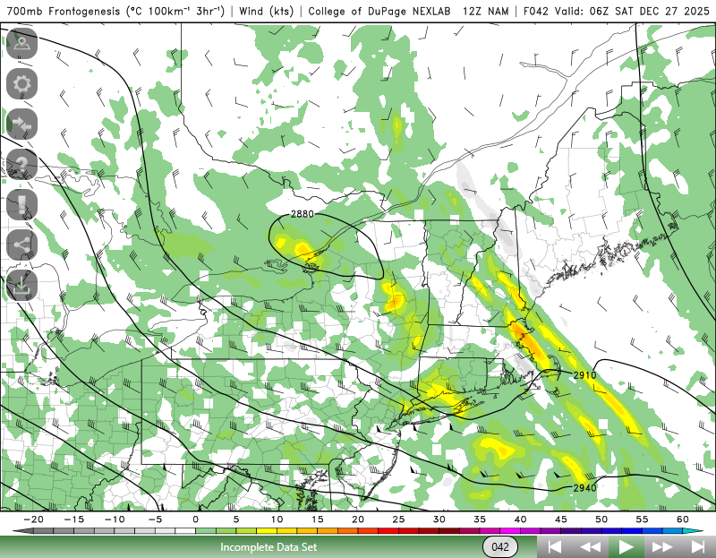
-
26th-27th event, coming at us like a wounded duck.
weatherwiz replied to Go Kart Mozart's topic in New England
Explains that jackpot of totals. I don't know if 4-5" per hour is happening but that would be absurd lol. -
26th-27th event, coming at us like a wounded duck.
weatherwiz replied to Go Kart Mozart's topic in New England
Holy shit..that might rip 2.5-3" per hour with thunder -
26th-27th event, coming at us like a wounded duck.
weatherwiz replied to Go Kart Mozart's topic in New England
Where the best of heaviest snow occurs max totals should be upwards of 7-8-9" or so. 10 might be tough just because of how fast the system is moving but it will probably dump 2" per hour under the band for a time.


