

weatherwiz
-
Posts
81,143 -
Joined
-
Last visited
Content Type
Profiles
Blogs
Forums
American Weather
Media Demo
Store
Gallery
Everything posted by weatherwiz
-
I literally have no clue what is wrong. Over the past week or two I've been making some insane typing errors. Like I am typing stuff that is not matching what I am thinking in my head...like missing words of a sentence or using incorrect verbiage (like saying uncertain but forgetting to add on "ty"...things like that). so weird
-
Pretty intrigued seeing mesos this impressive still this close in
-
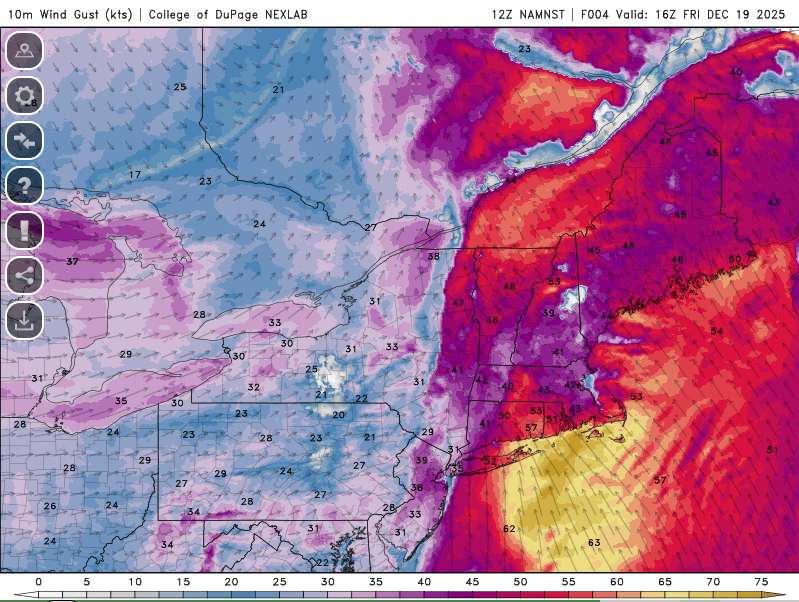
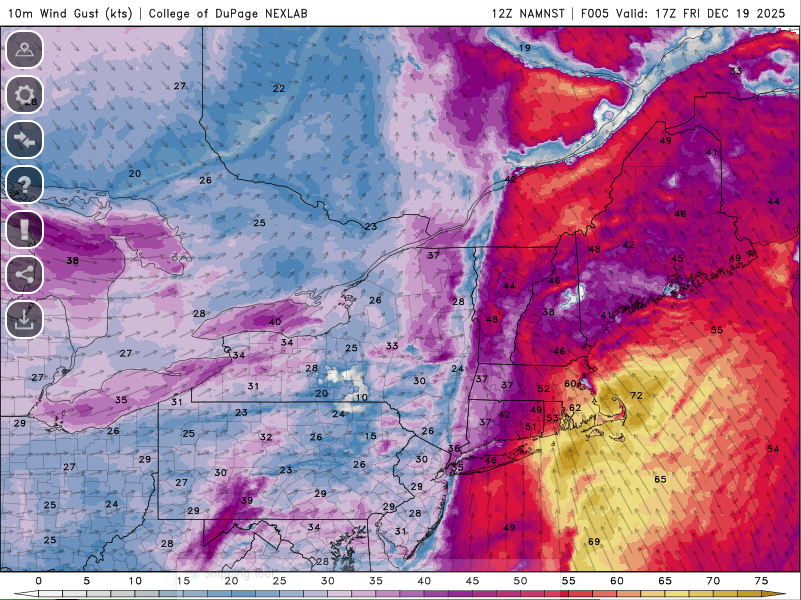
3km is pretty wild out east late morning and early afternoon. If we can dry out behind this bath of rain there could be some room for 65-70 mph gusts.
-

December 2025 regional war/obs/disco thread
weatherwiz replied to Torch Tiger's topic in New England
yeah I imagine that might rip some solid gusts just out ahead of it or along it. Beautiful looking fine line -
December 2025 regional war/obs/disco thread
weatherwiz replied to Torch Tiger's topic in New England
Its a cesspool for weather...absolutely horrible. Believe it or not though, I think its actually worse for severe weather than it is in winter weather. The severe weenies on there are awful -
Some good winds on OKX with that and very low too
-
yeah soundings are solid looking. I suppose there could be potential for a brief spinup along the leading edge today. I know there had a few warnings around STL yesterday and in fact, the line looks pretty similar to what went across that area yesterday.
-
Kind of interesting the SVR in NE PA has a tornado possible tag. Only instability is elevated
-
I was just going to come with this. Been interested in this for a few days. HRRR has remained consistent with this signal. HRRR also remains impressive EOR today
-
@Typhoon Tip got his marginal
-
December 2025 regional war/obs/disco thread
weatherwiz replied to Torch Tiger's topic in New England
Couple solid gusts in upstate NY too -
December 2025 regional war/obs/disco thread
weatherwiz replied to Torch Tiger's topic in New England
Quite warm out. Snow evaporating before the eyes. -
December 2025 regional war/obs/disco thread
weatherwiz replied to Torch Tiger's topic in New England
DDH with a 59 mph win gust at 5:10 (saw on RadarScope). Wonder if that’s legit -
December 2025 regional war/obs/disco thread
weatherwiz replied to Torch Tiger's topic in New England
3km remains impressive looking. Really interested to see how we look in the AM, particularly with satellite -
December 2025 regional war/obs/disco thread
weatherwiz replied to Torch Tiger's topic in New England
Yeah something is definitely up with how he's pulling the data or processing it. -
December 2025 regional war/obs/disco thread
weatherwiz replied to Torch Tiger's topic in New England
For a second I thought we were looking at a tropical system somewhere -
December 2025 regional war/obs/disco thread
weatherwiz replied to Torch Tiger's topic in New England
what in the sam hell. What boundary layer physics/equations are used by the HRDPS? That looks like its mixing down 100% of 925mb lmao. Does it think 10m is 925mb -
December 2025 regional war/obs/disco thread
weatherwiz replied to Torch Tiger's topic in New England
RRFS has some big gusts tomorrow too -
December 2025 regional war/obs/disco thread
weatherwiz replied to Torch Tiger's topic in New England
Was just going to post on that. Some of the soundings are pretty impressive I'm also curious about the potential for some squalls to fire up later in the afternoon. -
December 2025 regional war/obs/disco thread
weatherwiz replied to Torch Tiger's topic in New England
Going to be an interesting day for sure. -
December 2025 regional war/obs/disco thread
weatherwiz replied to Torch Tiger's topic in New England
Still have to watch though because if its just a non stop rain with no break between the initial area and line ahead of the front, gusts will be greatly diminished. It looks like the window for gusts 50-60+ is going to be relatively small and might end up being something more localized versus widespread. If there is a break between the initial area and incoming line, it will absolutely rip for a few hours -
December 2025 regional war/obs/disco thread
weatherwiz replied to Torch Tiger's topic in New England
yup for sure. I am definitely a bit more intrigued than I was 24 hours ago. -
December 2025 regional war/obs/disco thread
weatherwiz replied to Torch Tiger's topic in New England
That LLJ does hang back through early afternoon. Unlike that setup some weeks back where models trended east with the LLJ inside of 48 hours...this one has not -
December 2025 regional war/obs/disco thread
weatherwiz replied to Torch Tiger's topic in New England
It certainly may be. It all depends on really what side of everything we're on. We could be southwesterly or northeasterly. Heck, probably even get a mixture of both. -
December 2025 regional war/obs/disco thread
weatherwiz replied to Torch Tiger's topic in New England
Part of me is wondering if there is some scaling back in that regard due to climo. I agree that we certainly may end up below average as a whole, but unless we get some persistent HP to our north...we are going to be caked into a southwesterly surface flow. But the boundary is going to be very close by. It really can go either way


