weatherwiz
-
Posts
81,144 -
Joined
-
Last visited
Content Type
Profiles
Blogs
Forums
American Weather
Media Demo
Store
Gallery
Everything posted by weatherwiz
-

December 2025 regional war/obs/disco thread
weatherwiz replied to Torch Tiger's topic in New England
I have these thoughts too. I've been creating composites of SSTs focusing on the Pacific for EL Nino/La Nina dating back to 1900 with a focus on the WPWP. There's lots of studies out there discussing how it has expanded over the last 2-3 decades along with the extension of the WHWP. But even with the Nina look...those 29-30C temps are extending well east, just past the dateline. Definitely sufficient to sustain strong convection around the dateline which I believe is something that enhances ridging across the NPAC?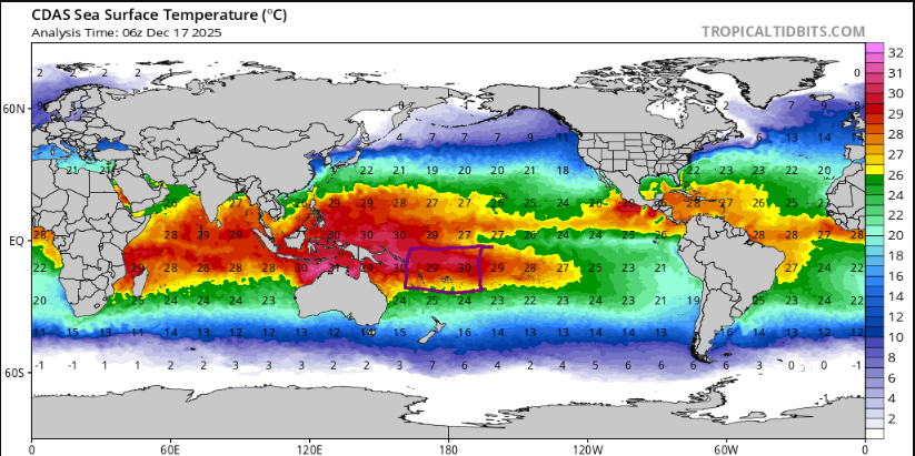
-
December 2025 regional war/obs/disco thread
weatherwiz replied to Torch Tiger's topic in New England
Do you have any blog posts which have explored the snowless periods of previous decades? I am really curious how this stretch compares/contrasts to those periods. I've always been under the impression those periods were the product of colder/drier winters (or moreso drier) while as this stretch we are still pulling off subpar seasons even when we're cold/wet. I mean who cares if we've gone through this before in the 1980's if its for completely different reasons. -
December 2025 regional war/obs/disco thread
weatherwiz replied to Torch Tiger's topic in New England
Despite the -PDO having leveled off, I think its still severely screwing us with shifting the East Asian jet north. -
December 2025 regional war/obs/disco thread
weatherwiz replied to Torch Tiger's topic in New England
I legit am nervous. I know its early, but in the grand scheme of things, we're already assessing how the pattern looks to evolve post Christmas into New Years. If that period ends up sucking then we'll be looking towards mid-January...and so forth. I truly believe we need to completely flush out the entire atmosphere...we probably need a good multi year stretch where ENSO is a non factor and then hope we are truly on the -PDO decline. At some point the odds have to return to our favor but the background state is far from it, IMO. -
December 2025 regional war/obs/disco thread
weatherwiz replied to Torch Tiger's topic in New England
Don't get him going -
December 2025 regional war/obs/disco thread
weatherwiz replied to Torch Tiger's topic in New England
Wouldn't mind getting this pattern in July. Monopoly Weather Chance Card: Take a ridge on the derecho express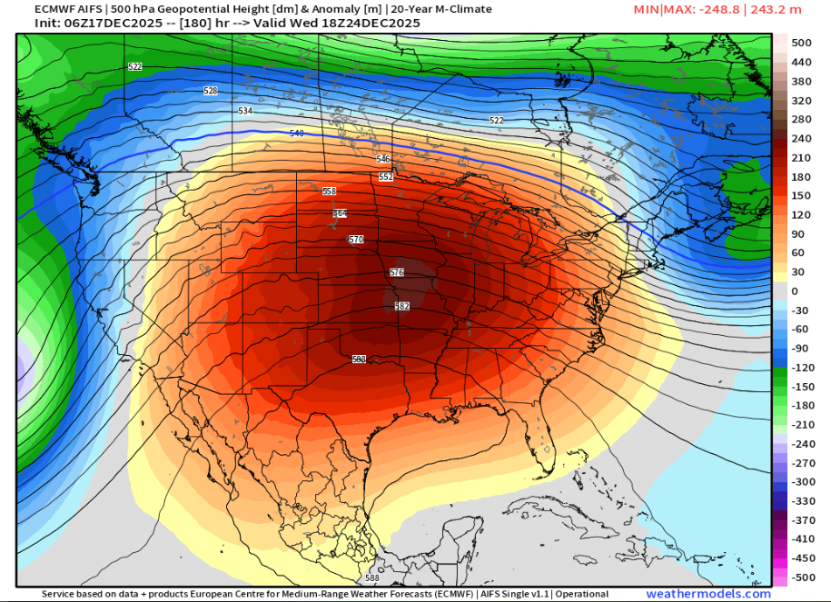
-
December 2025 regional war/obs/disco thread
weatherwiz replied to Torch Tiger's topic in New England
Thank God -
December 2025 regional war/obs/disco thread
weatherwiz replied to Torch Tiger's topic in New England
When I was walking out to the car this morning a massive owl flew overhead. Took me a second to realize what it was...thought it was a pterodactyl at first and was about to dive in a bush -
December 2025 regional war/obs/disco thread
weatherwiz replied to Torch Tiger's topic in New England
Stagnant air too. Air Quality alerts for all the weed smoke hanging at ground level? -
December 2025 regional war/obs/disco thread
weatherwiz replied to Torch Tiger's topic in New England
Sure does. in fact, some of the greatest gust potential was on PVD sounding lol. -
December 2025 regional war/obs/disco thread
weatherwiz replied to Torch Tiger's topic in New England
There is going to be lots of precipitation around which will hold back gusts overall. If we had little precip ahead of the main line and even got some cloud breaks...we would rip pretty good. This could happen locally, probably better shot towards interior eastern Mass. But I also think there is room for thunderstorms embedded within the line moving into far eastern CT, RI, eastern Mass and that will have to be watched. -
December 2025 regional war/obs/disco thread
weatherwiz replied to Torch Tiger's topic in New England
Bufkit isn't terribly impressive in terms of wind gust potential Friday. Very weak lapse rates present and a saturated profile. Sustained winds though looks solid...could be sustained 30-35 across the Cape. This isn't to say there is 40-50 mph gusts potential but we'll need convection and need to see some drying within some of the profiles. The typical elevated areas will gusts well -
December 2025 regional war/obs/disco thread
weatherwiz replied to Torch Tiger's topic in New England
I feel like too we haven't had "classic" blocking...but I think a big part of it too is blocking is much more beneficial for southern streams working up the coast. blocking with northern streams just results in one of two things, which you mentioned, cutting if the s/w is too strong and shredding the s/w or sending south if it is too weak. -
December 2025 regional war/obs/disco thread
weatherwiz replied to Torch Tiger's topic in New England
Wow, don’t recall seeing that outside of Cali before -
December 2025 regional war/obs/disco thread
weatherwiz replied to Torch Tiger's topic in New England
Weeklies are warm for January? big month of cold and snow incoming -
December 2025 regional war/obs/disco thread
weatherwiz replied to Torch Tiger's topic in New England
yeah eastern areas def have greatest potential to get temperatures well into the 50's and some stronger wind...perhaps even some convection too -
December 2025 regional war/obs/disco thread
weatherwiz replied to Torch Tiger's topic in New England
I'm sure they will have a top notch cooling system that is going to be cranking (can't even imagine the cost) but I have to think there will be some issues with the ice. -
December 2025 regional war/obs/disco thread
weatherwiz replied to Torch Tiger's topic in New England
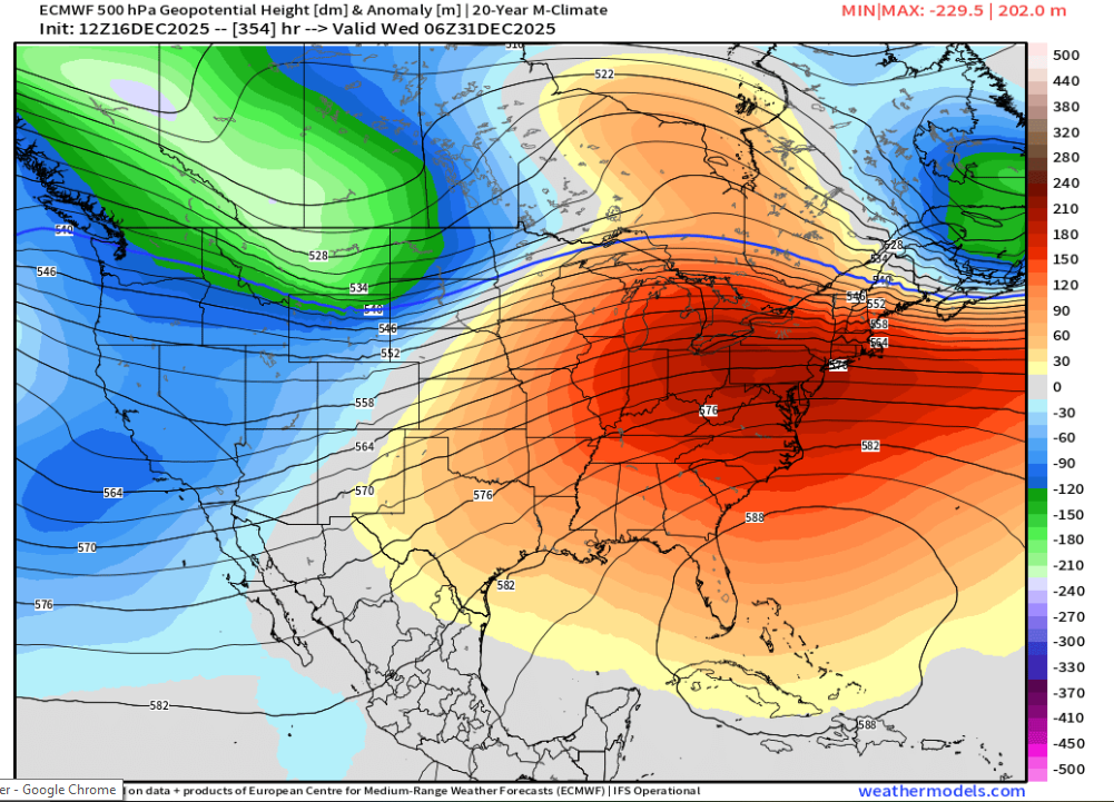
With this ridge centered over Florida they may be playing the outdoor classic on a pond. It will be a water polo match instead of a hockey match
-
December 2025 regional war/obs/disco thread
weatherwiz replied to Torch Tiger's topic in New England
I would be shocked if there isn't some widespread, high impact winter weather somewhere along the northern tier of the country mid-to-late week. There is no way we go through that without something somewhere -
December 2025 regional war/obs/disco thread
weatherwiz replied to Torch Tiger's topic in New England
I bet they enjoyed a good ice storm -
December 2025 regional war/obs/disco thread
weatherwiz replied to Torch Tiger's topic in New England
Santa's been around since the start of time -
December 2025 regional war/obs/disco thread
weatherwiz replied to Torch Tiger's topic in New England
Bring on a Christmas Ice Storm. The cave people did Christmas without electricity, we can too. -
December 2025 regional war/obs/disco thread
weatherwiz replied to Torch Tiger's topic in New England
I wonder if we start Friday with some very dense fog -
December 2025 regional war/obs/disco thread
weatherwiz replied to Torch Tiger's topic in New England
whoops...that should have just said Long Island...not the sound lol. Long Island had a nice little hit from the storm. But I guess looking deeper...it will be difficult to prevent temps/dews from climbing into the lower 50's though I am curious to see how far north we can get those. Could struggle to get the warm front to lift much past the Pike. If that sfc low either trends a bit farther southeast or a weak wave develops along the front...the warm sector would get squashed a bit. Probably would see a funny shaped front -
December 2025 regional war/obs/disco thread
weatherwiz replied to Torch Tiger's topic in New England
the NAM hints at that potential but it has a little pocket of steeper lapse rates and some higher MUCAPE. The NAM I think can often overdo those in these setups but its not unheard of to get some thunder/lightning with these, especially towards the outer Cape/Islands.