-
Posts
80,234 -
Joined
-
Last visited
Content Type
Profiles
Blogs
Forums
American Weather
Media Demo
Store
Gallery
Everything posted by weatherwiz
-

Spooky Season (October Disco Thread)
weatherwiz replied to Prismshine Productions's topic in New England
looks like a nice little wind core aloft not far up -

Spooky Season (October Disco Thread)
weatherwiz replied to Prismshine Productions's topic in New England
and happy opening night for the Bruins hockey is back!!!! -

Spooky Season (October Disco Thread)
weatherwiz replied to Prismshine Productions's topic in New England
Wonder if we end up seeing any lightning/thunder from Guilford on east across the shoreline -

Spooky Season (October Disco Thread)
weatherwiz replied to Prismshine Productions's topic in New England
The rain is NUTS in Branford right now. Even a bit gusty -

Spooky Season (October Disco Thread)
weatherwiz replied to Prismshine Productions's topic in New England
definitely something to watch given trees are still quite full with leaves...but alot of leaves and trees will come down -

Spooky Season (October Disco Thread)
weatherwiz replied to Prismshine Productions's topic in New England
6z GFS has 57 knots for IJD and 54 knots HFD -

Spooky Season (October Disco Thread)
weatherwiz replied to Prismshine Productions's topic in New England
GFS not backing down. Would be one heck of a coastal flooding event too, particularly southwestern sound. -

Spooky Season (October Disco Thread)
weatherwiz replied to Prismshine Productions's topic in New England
Yup...not totally buying it. For whatever reason, the GFS has become pretty amped/phase happy in that range these last several years. It seems overall models have really struggled with northern stream evolutions and energy flowing within the stream. Maybe this is just in part due to enhanced flow but I hope there are some group of people out there doing some research into this. Whether its mostly background state or whether its with the physics/equations its odd and leading to so many hyped forecasts. -

Spooky Season (October Disco Thread)
weatherwiz replied to Prismshine Productions's topic in New England
Potentially, but verbatim that wouldn't be the case. The GFS takes its sweet time occluding the storm and we have a strong feed of warm/moist llvl air feeding into the region with the llvl warm front right along the coast and 700 warm front farther inland. That would be a recipe for some heavy rainfall across all of SNE...but as occlusion begins to occur we would start seeing the shield breakup a bit. -

Spooky Season (October Disco Thread)
weatherwiz replied to Prismshine Productions's topic in New England
Substantial differences with the northern energy lol and subsequently how the two interact. God I feel like we're dealing with winter . -

Spooky Season (October Disco Thread)
weatherwiz replied to Prismshine Productions's topic in New England
Could also be an early season near blizzard within Montana and western North Dakota. Helluva shortwave trough digging in there -

Spooky Season (October Disco Thread)
weatherwiz replied to Prismshine Productions's topic in New England
I mean we'll have to see how quickly occlusion would occur...GFS is on the slower side with it but that's a pretty good rain maker setup and would probably be a stripe of some impressive totals somewhere. -

Spooky Season (October Disco Thread)
weatherwiz replied to Prismshine Productions's topic in New England
If that evolution plays out it will certainly put a dent in the rainfall deficits -
Wow! Well the streak ends I guess
-
yeah January 2021 certainly did and was aided by the extreme blocking across Greenland.
-
Yeah...we did get a great pattern late February and March and established prime troughing for us
-
I think it is extremely difficult right now to have an idea of what influences La Nina will have. There has been a markedly big shift in the hemispheric regime during La Nina events over the past few decades. With La Nina you always at least had some degree of troughing in North America, whether that be into Canada that would extend into the northern latitudes of the U.S. or into the PAC NW...but this signal has been almost absent mins 2010-2011 and 2021-2022 basically since the 80's.
-
I've tended to shy away from ONI alone and incorporate for SOI/MEI/RONI/ENS-ONI but with that I am a bit uncertain as to how much we really develop into La Nina but even with a Nina, I am unsure how "Nina like" the atmosphere will truly be. Thanks for linking that paper, gave a quick breeze through but need to read it in full later. I certainly could see periods where MJO activity is favorable or more favorable for us, but the question is, how favorable? If/when we get MJO activity into the favorable phases, how strong will the MJO signal be and how much weight will it have? But I really want to see how the hemisphere evolves through the remainder of this month and first half of November.
-
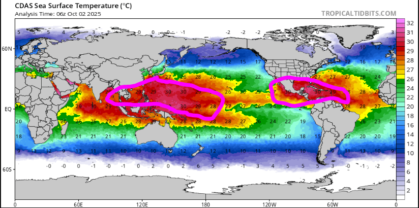
Well like I said, I won't have time to do in-depth digging or analysis, but regardless, 90% of "seasonal" outlooks always find some way to make it cold/snow in the East. Anyways, regardless of whether we end up in La Nina (by ONI definition) or neutral negative, much of the Pacific remains a heat pump. Now, I know things may change some in this department as we move towards the northern hemisphere winter solstice but the IPWP and WPWP remain expansive, which has been a theme for the last several years. In the case of the IPWP, when combined with the -PDO regime, is going to yield a stronger gradient across the North Pacific as we move deeper through the cooler season (lower pressure over the IPWP and higher pressure in the north Pacific) which will contribute to a very fast jet stream yielding zonal flow into the U.S. I'm fearful this is a recipe for strong MJO activity when convection enters phases 5-7 and we all know what that means. The WPHP is going to continue the theme of intense southern ridging and this could be even amped a bit by a weak La Nina or negative neutral ENSO and will aid in faster jet stream winds across the country. But of course you have wildcards such as stratosphere, QBO, etc. But when the PAC is a dominant player in this regard...it doesn't usually bode well for us.
-
Won't be able to put anything of great depth or detail together for the winter, but my thinking right now is that it is going to be a above average temperature regime for much of the country and could be on the drier side, except maybe the West and we'll see an overall theme of de-amplifying systems trucking across the country with another raging jet the culprit.
-
We're barely going to be in a La Nina, if we even officially get there. ENSO will probably have little influence on the overall regime.
-

Spooky Season (October Disco Thread)
weatherwiz replied to Prismshine Productions's topic in New England
I like the 6 panel viewings. I hope they bring back NARR. -

Spooky Season (October Disco Thread)
weatherwiz replied to Prismshine Productions's topic in New England
Wow, I had no clue EWALL made major upgrades! https://mapwall.met.psu.edu/ewall/ -
-

Spooky Season (October Disco Thread)
weatherwiz replied to Prismshine Productions's topic in New England
I was just thinking, is it me or does it seem like the hemisphere as a whole, particularly Arctic latitudes, is very slow to begin the seasonal transition...or maybe its just a bit too early? This next part is better suited for the ENSO thread, but I don't feel good about our prospects for the winter. I guess maybe I'll go throw those thoughts in there shortly.


