weatherwiz
-
Posts
81,133 -
Joined
-
Last visited
Content Type
Profiles
Blogs
Forums
American Weather
Media Demo
Store
Gallery
Everything posted by weatherwiz
-

26th-27th event, coming at us like a wounded duck.
weatherwiz replied to Go Kart Mozart's topic in New England
I had to turn off mPING reports. 8,000,00 report about how sidewalks are being covered with snow. I'm looking for totals and trying to decipher rates. Don't need to know your sidewalk is covered -
26th-27th event, coming at us like a wounded duck.
weatherwiz replied to Go Kart Mozart's topic in New England
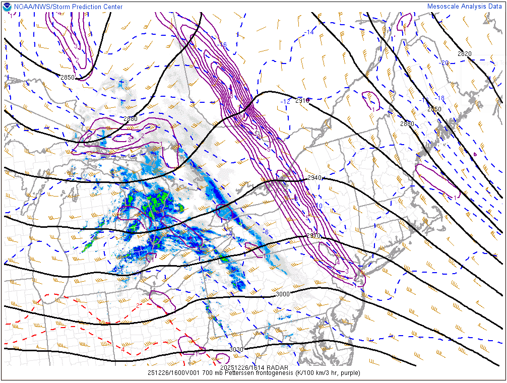
This really got solidified quickly. This is a phenomenal sign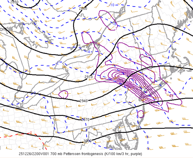
-
26th-27th event, coming at us like a wounded duck.
weatherwiz replied to Go Kart Mozart's topic in New England
the is a well defined warm front. this along with the fronto has to yield encouragement for along and EOR.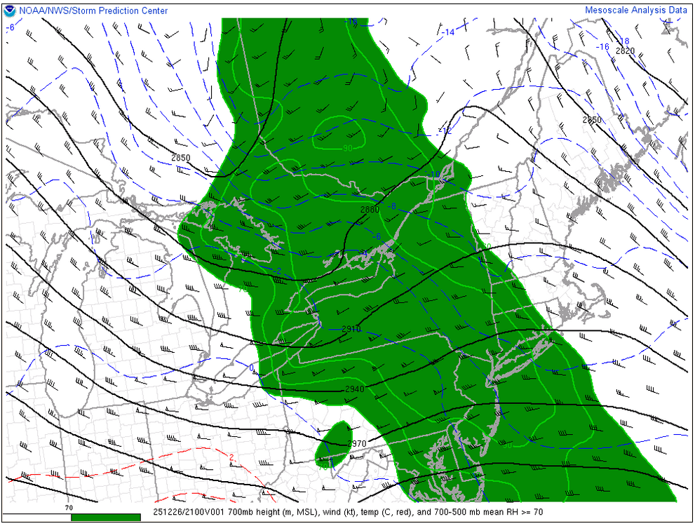
-
26th-27th event, coming at us like a wounded duck.
weatherwiz replied to Go Kart Mozart's topic in New England
I don't know. We dry out the DGZ very quickly so precipitation is going to shut off quickly. A reason why I think many could actually end as a bit of sleet or freezing drizzle. But this is also why I think 18z NAM QPF is out too lunch...still has QPF falling when we've essentially dried out the DGZ. If we're still snowing past that time its Arctic sand and won't accumulate -
26th-27th event, coming at us like a wounded duck.
weatherwiz replied to Go Kart Mozart's topic in New England
THERE IT IS!!! -
26th-27th event, coming at us like a wounded duck.
weatherwiz replied to Go Kart Mozart's topic in New England
yeah they're doing well there. Seems like the drier air though is having a difficult time saturating in eastern PA into NJ. In fact, looks like dewpoints have even dropped some over the last few hours, even our region. -
26th-27th event, coming at us like a wounded duck.
weatherwiz replied to Go Kart Mozart's topic in New England
Crazy to think its about 2.5-3 hours it will be dumping snow. Snowing by 6-6:30 for most with a quick 2-3 hour pukeage of snow then it starts to taper off by 10-11. Fun time ahead -
26th-27th event, coming at us like a wounded duck.
weatherwiz replied to Go Kart Mozart's topic in New England
Don't even think anything is reaching the ground east of IPT. There is going to be some QPF lost due to dry air along the leading edge. -
26th-27th event, coming at us like a wounded duck.
weatherwiz replied to Go Kart Mozart's topic in New England
I wouldn't be surprised if many ends as a little sleet or freezing drizzle but cut those 18z QPF totals down a bit -
26th-27th event, coming at us like a wounded duck.
weatherwiz replied to Go Kart Mozart's topic in New England
LOL at the NAM...way zoinked with QPF -
26th-27th event, coming at us like a wounded duck.
weatherwiz replied to Go Kart Mozart's topic in New England
The simulated reflectivity of the HRRR goes to show how fickle this really will be tonight and how important being able to get under banding will be. -
26th-27th event, coming at us like a wounded duck.
weatherwiz replied to Go Kart Mozart's topic in New England
I really wouldn't use snow maps to quantify trends with potential snow bands -
26th-27th event, coming at us like a wounded duck.
weatherwiz replied to Go Kart Mozart's topic in New England
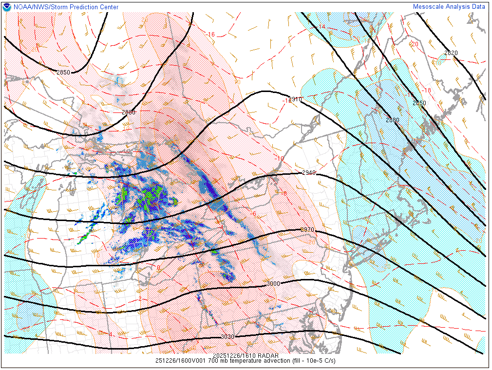
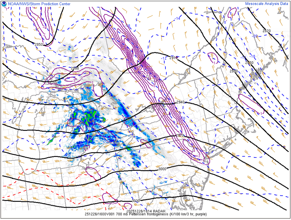
Not sure if this means much but I don't think the dewpoints were as low as modeled, we still have quite the dewpoint depression but maybe this will help to saturate more quickly? But we can already start watching everything evolve in real time. Pretty strong surge of WAA at 700mb just to our west and we have our established zone of 700mb fronto Two things we're going to want to watch through the afternoon are 1. How strong does the WAA remain 2. How quickly/when does it begin to weaken? But this look right now is certainly promising for western areas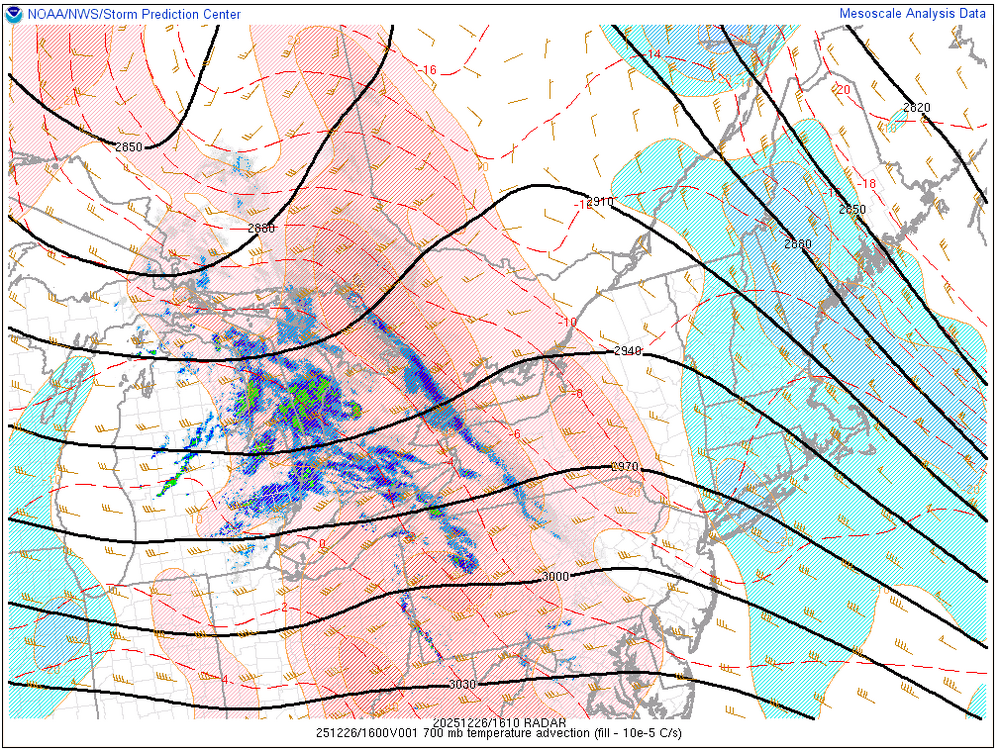
-
26th-27th event, coming at us like a wounded duck.
weatherwiz replied to Go Kart Mozart's topic in New England
I am going to LOVE tracking this one in real time. At this point we can put the models away, put the QPF maps away, and stop beating "QPF trends" with a hammer. None of that really matters because it's all about how the banding is going to evolve, where the banding traverses, and whether we see multiple or even several bands. So it all comes down to the evolution of the mid-level with respect to frontogenesis and the 700mb warm front. This one is going to have major surprises and there is no way to pin those down, even at this time frame. You may see a scenario where you have a narrow swath of 6-7" and you go 10-15 miles on either side of this swath and totals are only 2-3". There is just no way to portray this on a map so the best you can probably do is a larger range and understand there is an equal chance of ending up on the lower range (perhaps even an inch or two below) as there is of ending up towards the higher range. With this I don't think I'll make any changes to my map from yesterday (don't even have time anyways). If anything I would probably adjust the boundaries of the totals maybe but I can't see adding in like an area of 6-9 or 6-10". Not sure how widespread that will be and that is going to happen where the best banding is. Other than this I think its definitely a good 4-7" for everyone but there will be reports as low as 3-4". -
26th-27th event, coming at us like a wounded duck.
weatherwiz replied to Go Kart Mozart's topic in New England
Lower Hudson Valley into Fairfield County I think may end up in the sweet spot. I was really thinking there was room for some of the heavier banding to end up pretty far north like the NAM has. Even though the NAM is kind of alone there are two things the NAM are great at sniffing out, warm layers and banding. But the NAM has seemed to back off on the intense fronto band it had on some earlier runs but also argues for multiple bands. But one thing that is going to enhance things in the Lower HV into Fairfield County will be the proximity to the mix line and 700 warm front. It will really dump here. If anyone is going to end up with something along the lines of 8-10" it will be within this area. I am wondering if the sharp cutoff line will end up from like just west of Springfield to around Hartford south to like Guilford. -
26th-27th event, coming at us like a wounded duck.
weatherwiz replied to Go Kart Mozart's topic in New England
I will be shocked if there aren't thundersnow reports in the Lower Hudson Valley/Fairfield County tonight -
26th-27th event, coming at us like a wounded duck.
weatherwiz replied to Go Kart Mozart's topic in New England
Electric Blue could get 7" and Kevin only 3" -
26th-27th event, coming at us like a wounded duck.
weatherwiz replied to Go Kart Mozart's topic in New England
I wanted to add a 2-4" area out that way on my map yesterday but kind of held off because of the uncertainty but it's an interesting signal and models can really struggle with that. -
26th-27th event, coming at us like a wounded duck.
weatherwiz replied to Go Kart Mozart's topic in New England
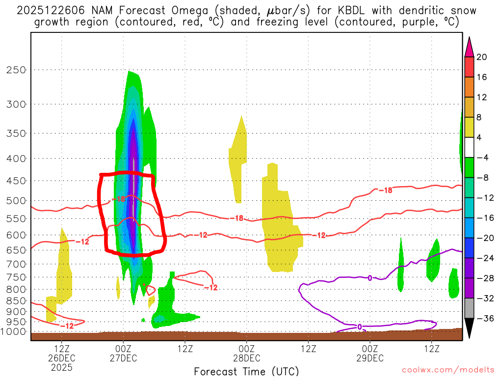
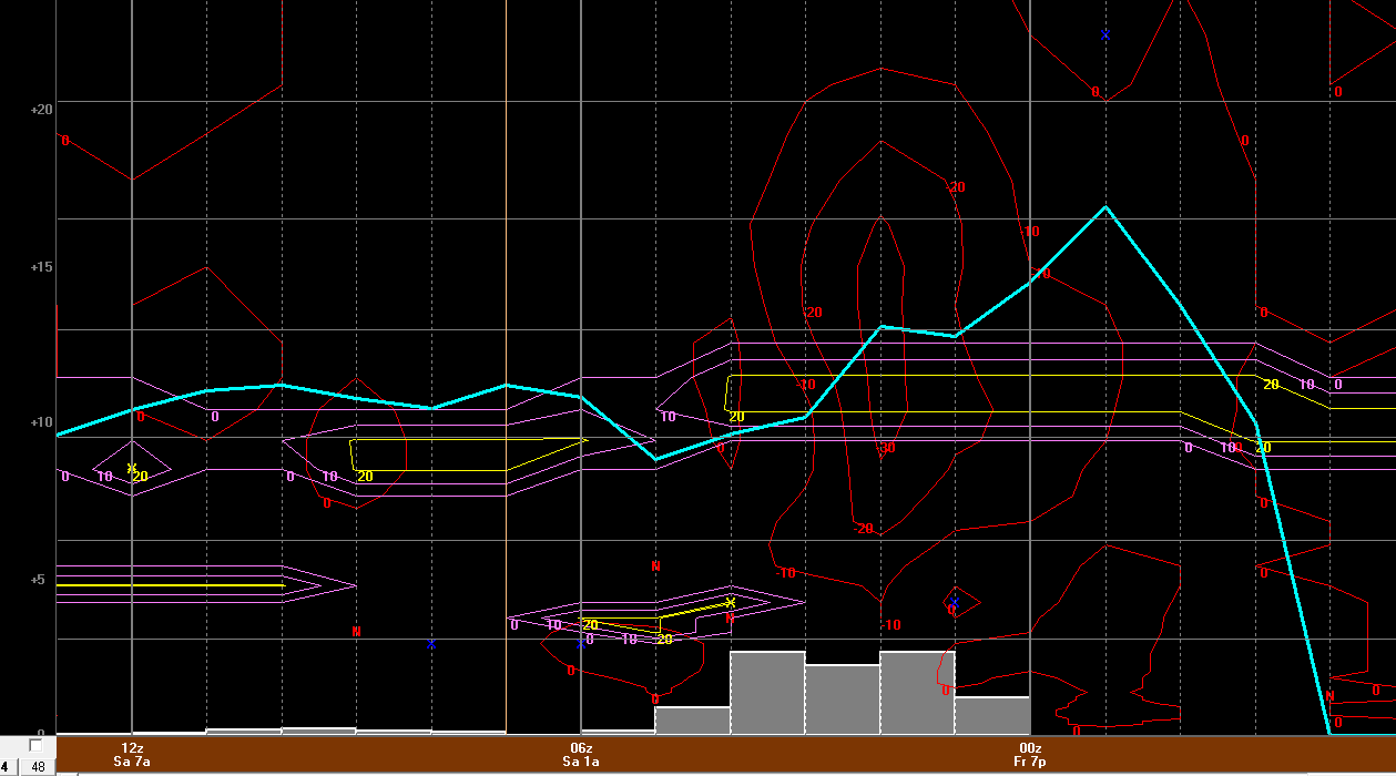
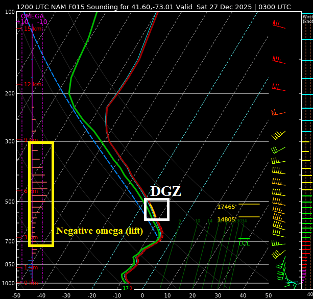
That is correct. When you see that signature that indicates strong upward vertical motion which will transport moisture into the DGZ and that's when you're most likely to get dendrites which accumulate efficiently. There are some other factors which need to be considered as well though. But here is an example from coolwx.com of the 6z NAM for BDL. This site is pretty cool if you don't have bufkit but you can see the maximum omega bisecting the DGZ Say you wanted to look for it on forecast soundings. What you would do is fine the DGZ (which is usually a colored as a yellow area on the temperature line) then on the left look at the omega (horizontal purple lines which indicate upward motion). The longer the lines, the stronger the lift and you want longer lines to match up to where the DGZ is.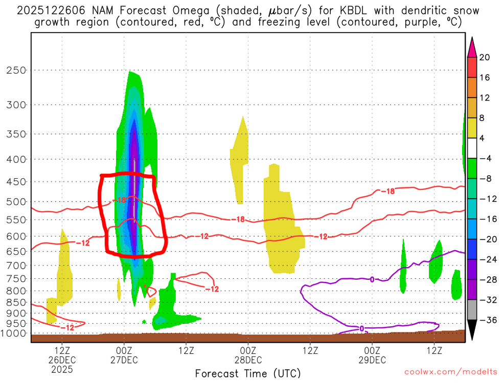
-
26th-27th event, coming at us like a wounded duck.
weatherwiz replied to Go Kart Mozart's topic in New England
ehhh some people put faith in the Cowboys every year -
26th-27th event, coming at us like a wounded duck.
weatherwiz replied to Go Kart Mozart's topic in New England
You would get into the heavy stuff too on the 3km. The 3km definitely isn't bad looking. Its a wall of snow coming in but it quickly starts to lose its oomph as it moves east. -
26th-27th event, coming at us like a wounded duck.
weatherwiz replied to Go Kart Mozart's topic in New England
the NAM really diminishes that fronto quickly. It's like a 2-3 hour period (if even 3 hours) of very heavy snow and done. Western CT/MA could get 6-7" and EOR could get like 2-3" lol. That cutoff is going to be pretty wild. Might have to re-think about the Fairfield County jack...that's probably best area to get thundersnow and rates closer to 3" per hour -
26th-27th event, coming at us like a wounded duck.
weatherwiz replied to Go Kart Mozart's topic in New England
Under the banding the snowfall rates would probably approach 2"/hr and maybe even upwards of 2.5". Feasibly, because of the crosshair signature (the -30 dissecting the snow growth zone) that should elicit great snowgrowth...the dendrites which accumulate quickly. I am a little worried though we may not get the perfect dendrites and snow growth will be a bit impacted by some dry air. The big question is what happens outside of the banding...that's where there could be more of a struggle and if we end up with multiple band signatures there will be some screw zones. In between these, perhaps even outside the banding, this is where you'll get more in the way of Arctic dust. Regardless, a widespread 4-7" is still in the cards but we need to be mindful there will be some screw zones. I don't think we'll see many totals eclipse 7-8" only because its really a 3 hour period of heavy accumulating snow and that's it. This is going to be fun to track in real time -
26th-27th event, coming at us like a wounded duck.
weatherwiz replied to Go Kart Mozart's topic in New England
6z NAM bufkit for BDL. When I see -30 into the DGZ I get all tingly
-
26th-27th event, coming at us like a wounded duck.
weatherwiz replied to Go Kart Mozart's topic in New England
Have I had too much egg nogg or are there double posts?