weatherwiz
-
Posts
81,139 -
Joined
-
Last visited
Content Type
Profiles
Blogs
Forums
American Weather
Media Demo
Store
Gallery
Everything posted by weatherwiz
-

26th-27th event, coming at us like a wounded duck.
weatherwiz replied to Go Kart Mozart's topic in New England
You would get into the heavy stuff too on the 3km. The 3km definitely isn't bad looking. Its a wall of snow coming in but it quickly starts to lose its oomph as it moves east. -
26th-27th event, coming at us like a wounded duck.
weatherwiz replied to Go Kart Mozart's topic in New England
the NAM really diminishes that fronto quickly. It's like a 2-3 hour period (if even 3 hours) of very heavy snow and done. Western CT/MA could get 6-7" and EOR could get like 2-3" lol. That cutoff is going to be pretty wild. Might have to re-think about the Fairfield County jack...that's probably best area to get thundersnow and rates closer to 3" per hour -
26th-27th event, coming at us like a wounded duck.
weatherwiz replied to Go Kart Mozart's topic in New England
Under the banding the snowfall rates would probably approach 2"/hr and maybe even upwards of 2.5". Feasibly, because of the crosshair signature (the -30 dissecting the snow growth zone) that should elicit great snowgrowth...the dendrites which accumulate quickly. I am a little worried though we may not get the perfect dendrites and snow growth will be a bit impacted by some dry air. The big question is what happens outside of the banding...that's where there could be more of a struggle and if we end up with multiple band signatures there will be some screw zones. In between these, perhaps even outside the banding, this is where you'll get more in the way of Arctic dust. Regardless, a widespread 4-7" is still in the cards but we need to be mindful there will be some screw zones. I don't think we'll see many totals eclipse 7-8" only because its really a 3 hour period of heavy accumulating snow and that's it. This is going to be fun to track in real time -
26th-27th event, coming at us like a wounded duck.
weatherwiz replied to Go Kart Mozart's topic in New England
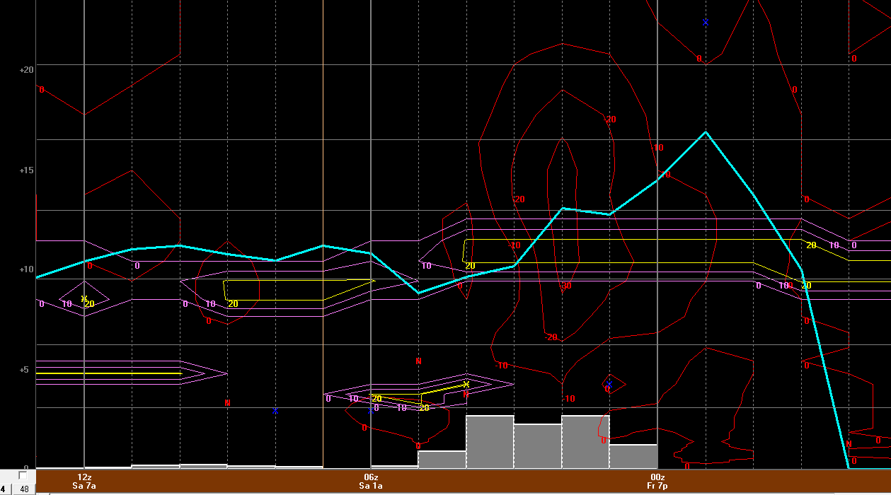
6z NAM bufkit for BDL. When I see -30 into the DGZ I get all tingly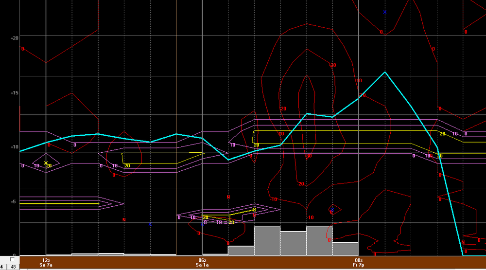
-
26th-27th event, coming at us like a wounded duck.
weatherwiz replied to Go Kart Mozart's topic in New England
Have I had too much egg nogg or are there double posts? -
26th-27th event, coming at us like a wounded duck.
weatherwiz replied to Go Kart Mozart's topic in New England
The ones that are still likely sleet for NYC? -
26th-27th event, coming at us like a wounded duck.
weatherwiz replied to Go Kart Mozart's topic in New England
There’s going to be a warm layer aloft but it probably won’t be significant for anyone in SNE but there’s a very real possibility NYC gets brief snow then goes to sleet. what the warm layer aloft will mean to us is where that warm front ends up residing and how strong exactly is it. Northeast of this is where the banding, snowfall rates, and ratios will be enhanced. -
26th-27th event, coming at us like a wounded duck.
weatherwiz replied to Go Kart Mozart's topic in New England
Ughhh sucks cod soundings still aren’t working for mobile -
26th-27th event, coming at us like a wounded duck.
weatherwiz replied to Go Kart Mozart's topic in New England
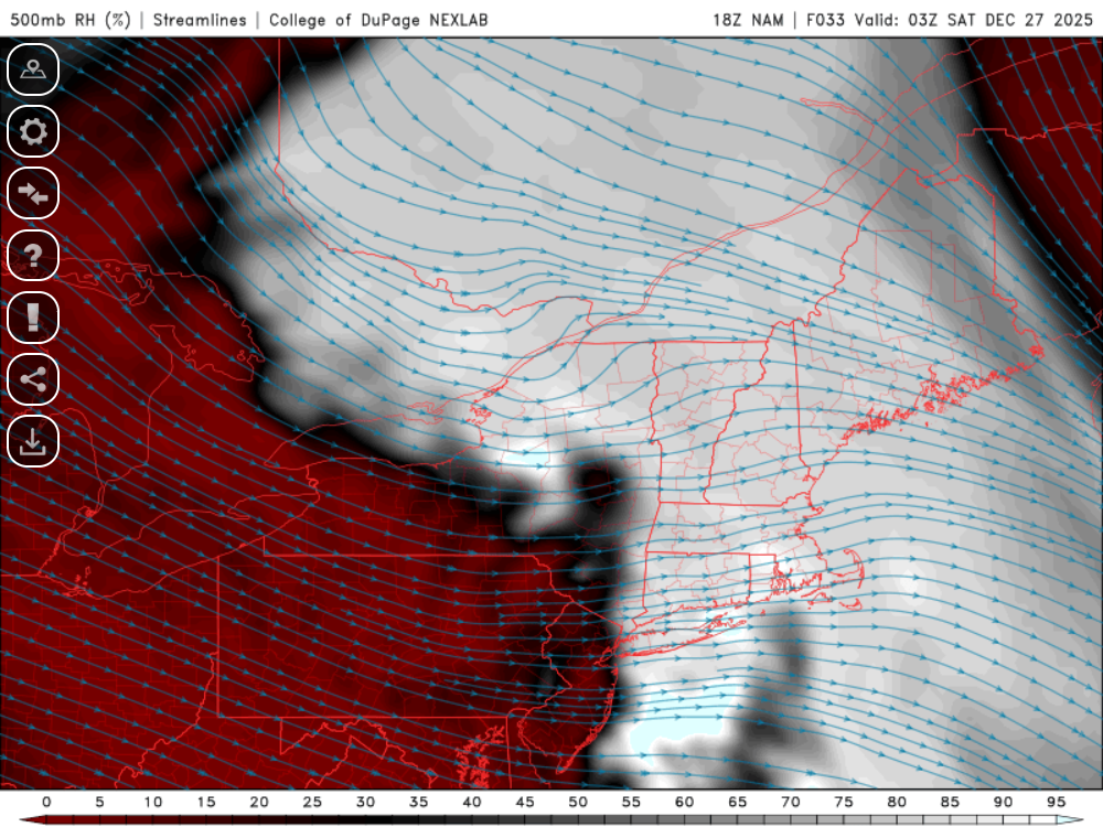
500/750 RH has me a bit nervous as to how robust the band may truly be. I’m still a little worried the overall axis is going to be quite narrow -
26th-27th event, coming at us like a wounded duck.
weatherwiz replied to Go Kart Mozart's topic in New England
That’s my thinking as well. It doesn’t look as impressive with the fronto and I’m taking that as the best banding will be more southwest of previous runs -
26th-27th event, coming at us like a wounded duck.
weatherwiz replied to Go Kart Mozart's topic in New England
I need 4.5” to hit 10” as well which would leave me with needing 90” to hit 100 -
26th-27th event, coming at us like a wounded duck.
weatherwiz replied to Go Kart Mozart's topic in New England
One factor to also consider for the swath of max totals is how wide is the band in reality. May end up a bit more narrow than what’s being shown via max QPF swath. -
26th-27th event, coming at us like a wounded duck.
weatherwiz replied to Go Kart Mozart's topic in New England
Once the storm passes -
26th-27th event, coming at us like a wounded duck.
weatherwiz replied to Go Kart Mozart's topic in New England
We have very similar thoughts on this. But you’ve been consistent since multiple days ago…took me a few days to catch on -
26th-27th event, coming at us like a wounded duck.
weatherwiz replied to Go Kart Mozart's topic in New England
Updated map and even a blog post https://weatherwiz.blogspot.com/2025/12/friday-december-26-2025-southern-new.html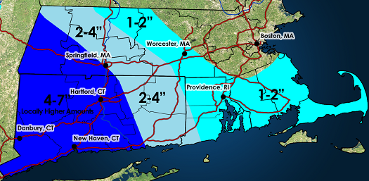
-
26th-27th event, coming at us like a wounded duck.
weatherwiz replied to Go Kart Mozart's topic in New England
It's very possible. If there is any setup that the NAM is going to outperform other guidance it is going to be this. The globals aren't particularly skillful when it comes to banding. In terms of other mesos, I don't even think the HRRR handles that well. The best thing I think to do is forget QPF amounts and QPF trends and using those to define the storm trends. The focus and assessment should be on the mid-levels and particularly that mid-level warm front. Often, models will produce the heaviest QPF right under directly under where the best dynamics or fronto or gradient is but more time than not the heaviest QPF is going to be displaced a bit north of this. -
26th-27th event, coming at us like a wounded duck.
weatherwiz replied to Go Kart Mozart's topic in New England
If you look at where models (NAM, GFS, Euro) have the 700mb warm front...the NAM actually I think makes sense with how far north and east it has the banding. I think the area of strongest frontogenesis on the 12z RGEM would be northeast of where it has it -
26th-27th event, coming at us like a wounded duck.
weatherwiz replied to Go Kart Mozart's topic in New England
do you know how well historically the RGEM handles banding? -
26th-27th event, coming at us like a wounded duck.
weatherwiz replied to Go Kart Mozart's topic in New England
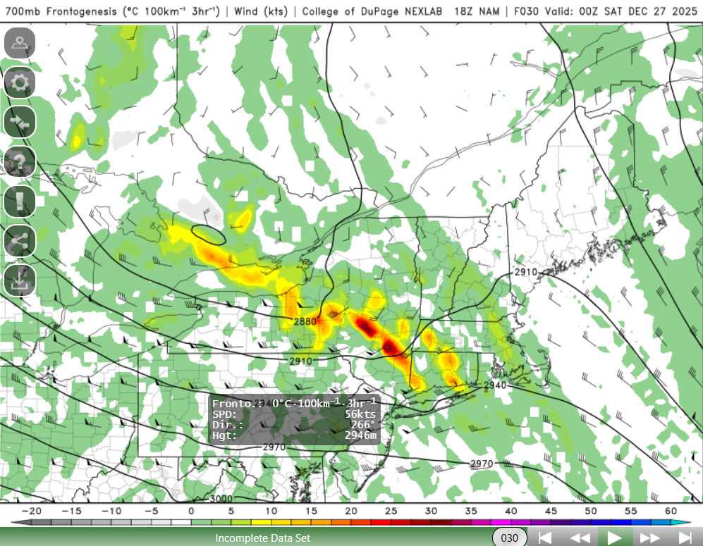
I am so torn on this. Dry air races in aloft. Here is simulated reflectivity for 3z. I choose this over QPF because that's 3hr QPF up until that hour. anyways...looks pretty good but look at 500mb RH (80-85% but dropping quickly) This heavy snow is going to be so brief and I have to suspect this will have some impact on ratios, except for directly under the banding. You could see something like Danbury get 7" and Waterbury barely 3" (just using those two locations to illustrate the tight gradient)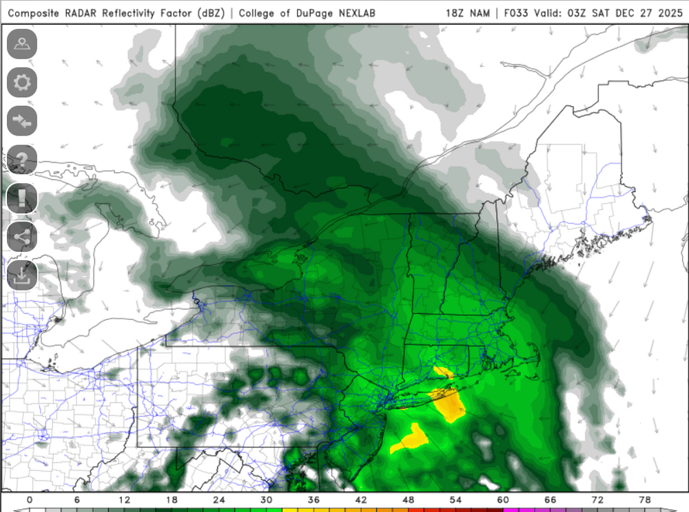
-
26th-27th event, coming at us like a wounded duck.
weatherwiz replied to Go Kart Mozart's topic in New England
Humpy dumpy came in like a wall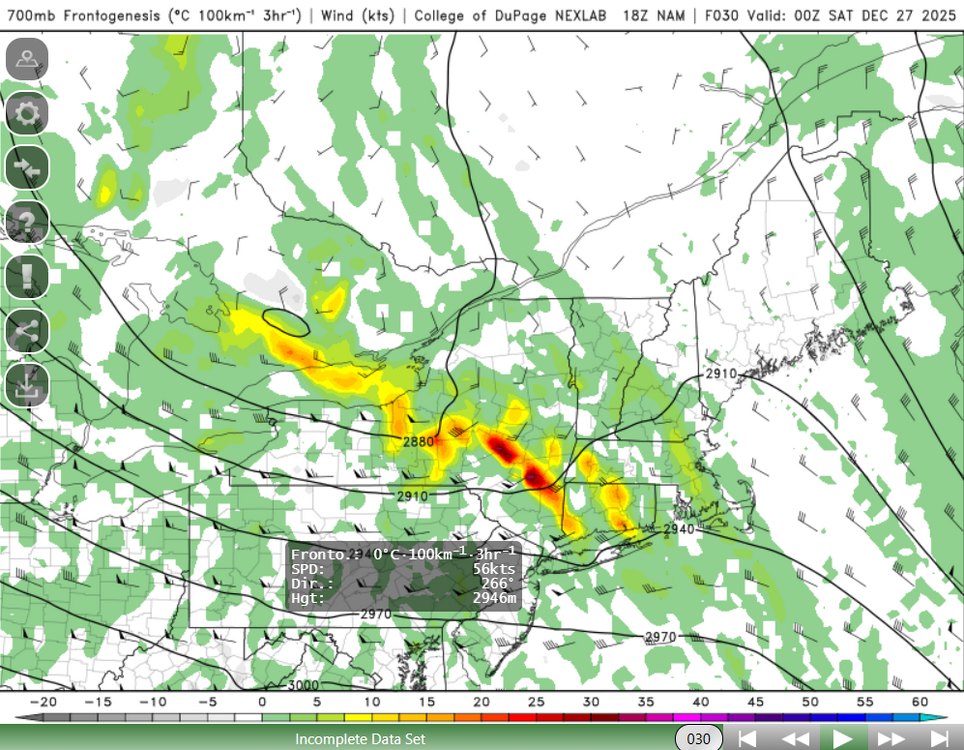
-
26th-27th event, coming at us like a wounded duck.
weatherwiz replied to Go Kart Mozart's topic in New England
Not sure. I usually don't really look around at maps until I've made one...unless I don't feel like making one lol. -
26th-27th event, coming at us like a wounded duck.
weatherwiz replied to Go Kart Mozart's topic in New England
Time to work on an updated snow map -
26th-27th event, coming at us like a wounded duck.
weatherwiz replied to Go Kart Mozart's topic in New England
Interesting...advisory for Hartford County -
26th-27th event, coming at us like a wounded duck.
weatherwiz replied to Go Kart Mozart's topic in New England
snow ratios are definitely going to be hefty under the banding...certainly upwards of 15:1, if not maybe even upwards of 18:1. Certainly leading to some potential that could even some 8-12" totals, even with the speed. The 10-15" I don't know about...those models were also pegging snowfall rates4-5"/hour. If that happened then we would see those totals I think but 4-5"/hr might be a bit high -
26th-27th event, coming at us like a wounded duck.
weatherwiz replied to Go Kart Mozart's topic in New England
Hopefully when you flush your phone goes down with it