

weatherwiz
-
Posts
81,144 -
Joined
-
Last visited
Content Type
Profiles
Blogs
Forums
American Weather
Media Demo
Store
Gallery
Everything posted by weatherwiz
-

December 2025 regional war/obs/disco thread
weatherwiz replied to Torch Tiger's topic in New England
Part of me is wondering if there is some scaling back in that regard due to climo. I agree that we certainly may end up below average as a whole, but unless we get some persistent HP to our north...we are going to be caked into a southwesterly surface flow. But the boundary is going to be very close by. It really can go either way -
December 2025 regional war/obs/disco thread
weatherwiz replied to Torch Tiger's topic in New England
I still think there is room for something bigger in the 28th-31st time frame, but perhaps not in the classic sense of what you would want the pattern to look like. I think its been mentioned several times, but we easily could see something along the lines of a late bloomer. But what happens during this period will be a big influence on how we evolve moving through the start of January. If the blocking develops as advertised (I think this is what would help with bigger storm potential in the time frame mentioned) but this probably leads to an increased risk that we do undergo a period of above average warmth early in January as the southern ridging connects with the block. If the blocking doesn't materialize then maybe we just remain more zonal and probably more towards the cooler side of average but not particularly active. -
December 2025 regional war/obs/disco thread
weatherwiz replied to Torch Tiger's topic in New England
Who the heck knows what to expect after Christmas. The signals are all over the place, especially with the structure and orientation of the pattern which will play a critical roll. If I had to be nervous about something post Christmas it would be shortwave moving into the West getting obliterated as they move across the Inter-mountain West...but there is really no sense of worrying about this nor any point to feeling confident or not confident. -
December 2025 regional war/obs/disco thread
weatherwiz replied to Torch Tiger's topic in New England
The best part IMO is getting data faster -
December 2025 regional war/obs/disco thread
weatherwiz replied to Torch Tiger's topic in New England
But AI handled the advection of cirrus clouds very well between the hours of 9:00 PM - 12:00 AM so maybe it will do well the next time we have cirrus advecting in!!!!!!!! -
December 2025 regional war/obs/disco thread
weatherwiz replied to Torch Tiger's topic in New England
Well at least a coating did fall...and then another couple inches on top of it -
December 2025 regional war/obs/disco thread
weatherwiz replied to Torch Tiger's topic in New England
Explains why your forecasts have gone downhill -
December 2025 regional war/obs/disco thread
weatherwiz replied to Torch Tiger's topic in New England
The real problem I think would be if the strong blocking persists. We would probably get chances as the block is materializing and then we'd want to hope for the block to relax or break down a bit and that could come with some chances. But if a big block materializes and becomes established...then we may be screwed -
December 2025 regional war/obs/disco thread
weatherwiz replied to Torch Tiger's topic in New England
I love the euro op phasing of a TPV piece with southern stream energy across the Carolinas towards the end of the run lol -
December 2025 regional war/obs/disco thread
weatherwiz replied to Torch Tiger's topic in New England
yeah soundings are quite inverted there. Looked like though there could be room for a line with thunder/lightning. Probably the only way to draw down any good gusts. -
December 2025 regional war/obs/disco thread
weatherwiz replied to Torch Tiger's topic in New England
some violence for the Cape on the 6z HRRR -
December 2025 regional war/obs/disco thread
weatherwiz replied to Torch Tiger's topic in New England
I wonder if we could see some snow squalls into western areas late Friday afternoon -
December 2025 regional war/obs/disco thread
weatherwiz replied to Torch Tiger's topic in New England
yeah and they seem to target coastal VA/NC. Should be getting a new D3 update though within the next 5-15 minutes. -
December 2025 regional war/obs/disco thread
weatherwiz replied to Torch Tiger's topic in New England
If the fun weather can't come to you, you go to it. I don't think I've ever seen a civil emergency message for wind before. Sure its happened but must be rare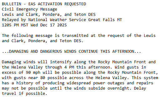
-
December 2025 regional war/obs/disco thread
weatherwiz replied to Torch Tiger's topic in New England
NAM/GFS do have an insane LLJ at 925 materialize across eastern CT/RI/E MA through Friday morning...so something to definitely keep an eye on if that can be tapped into. This does happen to coincide with the leading edge of the main rain area too, however, there is a stout inversion too -
December 2025 regional war/obs/disco thread
weatherwiz replied to Torch Tiger's topic in New England
I wouldn't be shocked if that ridging in the south is too smoothed out too. I would wager probably more of a ridge axis into the upper Mississippi Valley which could then argue for some lower heights in the Northeast The overall structure of that trough across western Canada's coast will be a big player too -
December 2025 regional war/obs/disco thread
weatherwiz replied to Torch Tiger's topic in New England
The stratosphere is certainly going to try and help get us a favorable Arctic domain.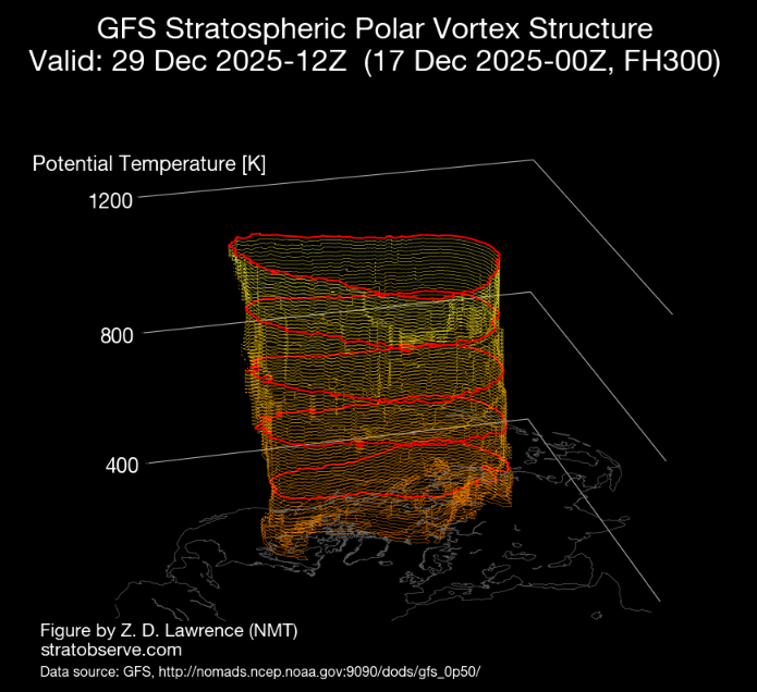
-
December 2025 regional war/obs/disco thread
weatherwiz replied to Torch Tiger's topic in New England
I hope its 85F on April 17 so I can watch playoff hockey outside with just a jersey on -
December 2025 regional war/obs/disco thread
weatherwiz replied to Torch Tiger's topic in New England
My recommendation for those people then would be to move to the Sierra's or Cascades lol. I mean if we're active with 3-4" events and people are still complaining then something is wrong. Surely we all want the big storm but there has to be some sort of realistic expectation too. -
December 2025 regional war/obs/disco thread
weatherwiz replied to Torch Tiger's topic in New England
I could see a marginal get thrown up for far eastern CT/RI/SE MA. the NAM would certainly argue it but sometimes the NAM gets a little overzealous with elevated in stability in these setups. NAM does have a pocket of steeper mid-level lapse rates (and greater CAPE) but I think its overdone in that regard. The key for eastern areas will be little to no shower activity ahead of the main area -
December 2025 regional war/obs/disco thread
weatherwiz replied to Torch Tiger's topic in New England
Yeah I agree, I definitely would like to start getting some bigger systems, but if we can pull off a good two week stretch where we get 3-4 systems in the 2-4" range...I would hope that makes everyone a bit happier lol. -
December 2025 regional war/obs/disco thread
weatherwiz replied to Torch Tiger's topic in New England
The 27-29 period looks like it could be interesting -
December 2025 regional war/obs/disco thread
weatherwiz replied to Torch Tiger's topic in New England
Well this isn't fair. Damn you Idaho
-
December 2025 regional war/obs/disco thread
weatherwiz replied to Torch Tiger's topic in New England
when you're in the Cascades -
December 2025 regional war/obs/disco thread
weatherwiz replied to Torch Tiger's topic in New England
The NBM does really well with sky cover forecasts I think. Out of MOS/NBM, the NBM was the only guidance bringing in these clouds through the day today followed by some clearing late afternoon/evening then increasing late.


