weatherwiz
-
Posts
81,160 -
Joined
-
Last visited
Content Type
Profiles
Blogs
Forums
American Weather
Media Demo
Store
Gallery
Everything posted by weatherwiz
-

Blowvember - and not named for wind potential
weatherwiz replied to Go Kart Mozart's topic in New England
Maybe we can combine all those periods the "EPS looked good" from last year, the winter before, and the winter before that with the upcoming "EPS looks good" period to produce one of the most prolific stretches ever. -
Saturday's seem to be best. I know the weeknights at Clark's have been great for those close to Boston during the week but for anyone outside of Boston that is pretty brutal. I think a Saturday like 12-1 PM for the early folks is perfect, even if someone stops by for 2-3 hours they're getting home at a reasonable time and still have time to do whatever else they may need to do for the day.
-
Blowvember - and not named for wind potential
weatherwiz replied to Go Kart Mozart's topic in New England
I do agree with that general idea but I think lately I've backed off on how strong I agree with that idea. The last I want to say 3-4 years (maybe even a little longer?) have either had anomalously wet periods or anomalously dry periods. And the anomalously wet periods during this stretch have become more wet and the anomalously dry periods have become even more dry. That is just an observation though - not trying to connect that to anything. But may this is something we're going to have to do with for a while...when we're getting favorable upward vertical motion over the CONUS we'll have precip event galore and maximize PWATs and when we have unfavorable vertical motion we won't be able to buy anything -
I think Funky Murphy's is so much better. 1. Its a more centralized location which can help with turnout. 2. The parking kind of blows but its much easier than trying tp park in Boston (and hell a cheaper...as in free). 3. We get that giant space in the back.
-
Blowvember - and not named for wind potential
weatherwiz replied to Go Kart Mozart's topic in New England
This I am not so sure about. If we get a -PDO/-AMO combo that may be the case. IIRC, doesn't -PDO phases tend to coincide with dryer than average conditions across the CONUS? -
Blowvember - and not named for wind potential
weatherwiz replied to Go Kart Mozart's topic in New England
Within our region, I don't think anyone sees any snow outside of the Greens and maybe parts of the Berkshires. This is where the most intense lifting would likely be. But I wouldn't be surprised if some flakes/graupel on Friday...in fact I bet many see at least some sort of frozen precip mixture. -
Blowvember - and not named for wind potential
weatherwiz replied to Go Kart Mozart's topic in New England
Maybe not bad after all for the Greens Thursday night into Friday morning -
Blowvember - and not named for wind potential
weatherwiz replied to Go Kart Mozart's topic in New England
Wow didn't realize how similar the NAM/Euro are in terms of how the entire system evolves...does the old NAM/Euro rule still exist Alot will probably depend on how quickly and where occlusion occurs. GFS is much quicker in this regard. -
Blowvember - and not named for wind potential
weatherwiz replied to Go Kart Mozart's topic in New England
NAM solution is probably best solution to give a widespread soaking rain for several hours. That's some pretty intense frontogenesis and WAA and convective precip...that's what we want. GFS makes me a little nervous about heavy rain on a widespread or larger scale. -
Blowvember - and not named for wind potential
weatherwiz replied to Go Kart Mozart's topic in New England
WSW out for the higher terrain in eastern West Virginia -
Blowvember - and not named for wind potential
weatherwiz replied to Go Kart Mozart's topic in New England
Gotcha. This is precisely why timing is just as, if not, more important when dealing with the "sensible" weather and when it comes to the states of PNA, EPO, NAO, AO, etc. its their trend over a 5-7D period which is more important than just want the index looks to become or average out to. I wish there was an easy way to do this and apply to historical events and for research purposes. I still would one love love to be able to take the daily index levels of the various indices and compute a weekly/bi-weekly rolling average. But I think this is extremely complex. I don't think its as simple as just taking the daily values and simply dividing by 7 or 14. A program could do this extremely easily, just have to come up with the proper equation. -
Blowvember - and not named for wind potential
weatherwiz replied to Go Kart Mozart's topic in New England
We need to get these to dump into the upper-Midwest/Ohio Valley region. I don't know the climatology with Arctic outbreaks, however, I would imagine they're more than likely to spill into the center U.S. (east of the Rockies) than they are into the upper-Midwest/Ohio Valley. Anyways, these things keep spilling into the Great Plains we just just end up on the warm end of systems and get the cold on the backside of systems as they pull out. Maybe we need them to spill deep into the southern Plains because that would focus cyclogenesis way south and increase the potential for off-shore tracks for us? -
Blowvember - and not named for wind potential
weatherwiz replied to Go Kart Mozart's topic in New England
Hell, I would even sell it for anywhere outside of the clouds where snowflakes would be produced. -
Blowvember - and not named for wind potential
weatherwiz replied to Go Kart Mozart's topic in New England
For here, I think I would rather just roll the dice with a below-average precip winter. I forgot who mentioned this but it seems like lately when we get above-average precip winters, it comes with warmer storms and we get more rain. There used to be a time when if we got above-average precip in the winter...it meant we got slammed with snow. Maybe below-average precip would mean a colder pattern and what storms we get actually produce...snow. -
Blowvember - and not named for wind potential
weatherwiz replied to Go Kart Mozart's topic in New England
Does the algorithm for snow maps just check to see if there is any part of a layer (even if its like 5 feet) that is like below 32 (or hell even below 40 because that's how ridiculous their outputs are), then just multiple total QPF by 10:1 and say, "yup this much snow is falling"? -
Blowvember - and not named for wind potential
weatherwiz replied to Go Kart Mozart's topic in New England
If you're hoping for a decent drink Wednesday night things continue to not look so great, IMO. The system becomes occluded Wednesday evening on the GFS well to our west. The better chance for some heavier rain is probably like PA/SE NY/NJ into SW CT right along maybe a triple point? As for any snow...yeah not happening, probably anywhere except the highest terrain. Even if a secondary pops it will be weak and certainly not anywhere close to enough dynamic cooling to do anything with. Someone above 1500 or 2000 feet will probably squeak out an inch or two but other than that nobody is seeing anything -
Blowvember - and not named for wind potential
weatherwiz replied to Go Kart Mozart's topic in New England
Should see some lower 60's around tomorrow but yeah could be our last 60's for a bit...probably Christmas like you said -
Blowvember - and not named for wind potential
weatherwiz replied to Go Kart Mozart's topic in New England
Sat outside for a few hour earlier, just a sunning day. A little breezy at times but manageable. -
Blowvember - and not named for wind potential
weatherwiz replied to Go Kart Mozart's topic in New England
and a closing off H5 low over Michigan with an occluding system, sfc temps barely in the mid 30s [in the high terrain], with 925 temperatures around -0C is going to produce that? -
Blowvember - and not named for wind potential
weatherwiz replied to Go Kart Mozart's topic in New England
when? -
Blowvember - and not named for wind potential
weatherwiz replied to Go Kart Mozart's topic in New England
1000% -
Blowvember - and not named for wind potential
weatherwiz replied to Go Kart Mozart's topic in New England
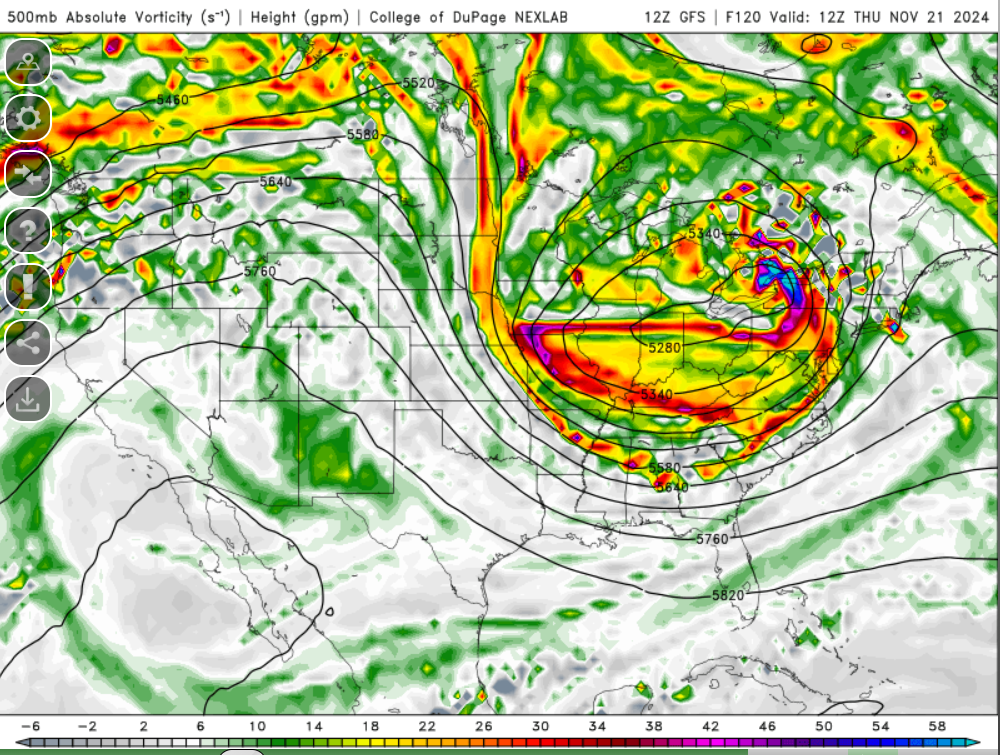
This is the 500mb level and is displaying absolute vorticity and the height, in meters, the 500mb level can be found at
-
Blowvember - and not named for wind potential
weatherwiz replied to Go Kart Mozart's topic in New England
Getting a bit excited for Thursday. Wouldn't be surprised to see a marginal risk with the D3 which comes out overnight Monday as long as things hold pat. -
Blowvember - and not named for wind potential
weatherwiz replied to Go Kart Mozart's topic in New England
Umm how about both -
Blowvember - and not named for wind potential
weatherwiz replied to Go Kart Mozart's topic in New England
Actually probably not, the Sun will be on the other side of the house and it will get chilly shaded over. Damn you cold