weatherwiz
-
Posts
81,154 -
Joined
-
Last visited
Content Type
Profiles
Blogs
Forums
American Weather
Media Demo
Store
Gallery
Everything posted by weatherwiz
-

Blowvember - and not named for wind potential
weatherwiz replied to Go Kart Mozart's topic in New England
It was my favorite part of wxbell. -
Blowvember - and not named for wind potential
weatherwiz replied to Go Kart Mozart's topic in New England
Then you definitely can't go wrong with cod. Probably one other aspect of wxbell that is underrated (I don't have it but school used to have a subscription so used it there) is its extremely user friendly navigating products, models, and comparing between models. While cod is great it involves alot of clicking around. -
Blowvember - and not named for wind potential
weatherwiz replied to Go Kart Mozart's topic in New England
yeah I remember that being a thing about them. I think i had SV way back in the day and the graphics/color schemes were brutal. Looked like something Kevin would spit up after one too many IPAs. -
Blowvember - and not named for wind potential
weatherwiz replied to Go Kart Mozart's topic in New England
What are you looking for really? Just day-to-day forecasting or more long-range? You really can't go wrong with cod, especially if you're looking for more day-to-day or more interested in when we have a potential storm. Cod and then complimenting bufkit for specific locations. I wish Cod had more products for HRRR/ability to generate soundings and I wish they had more products for ensembles but for a free site, its easily the best. -
Blowvember - and not named for wind potential
weatherwiz replied to Go Kart Mozart's topic in New England
forgot about that site -
Blowvember - and not named for wind potential
weatherwiz replied to Go Kart Mozart's topic in New England
It would be great if there was a wider selection for option, especially for winter weather forecasting. The winter weather selection just consists of snow maps, Ptype, and sleet accumulation. They have the basics for each level but I think COD (which is free) is far superior and has much better graphics...must easier visually. For $10/month it isn't bad because that comes with access to city charts and forecasts for teleconnections. I do like the EPS products for tropical and what they have for ensemble information but I think something like Ray mentioned, f5 plus weatherbell is the better route to go. -
Blowvember - and not named for wind potential
weatherwiz replied to Go Kart Mozart's topic in New England
weathermodels.com sucks -
Blowvember - and not named for wind potential
weatherwiz replied to Go Kart Mozart's topic in New England
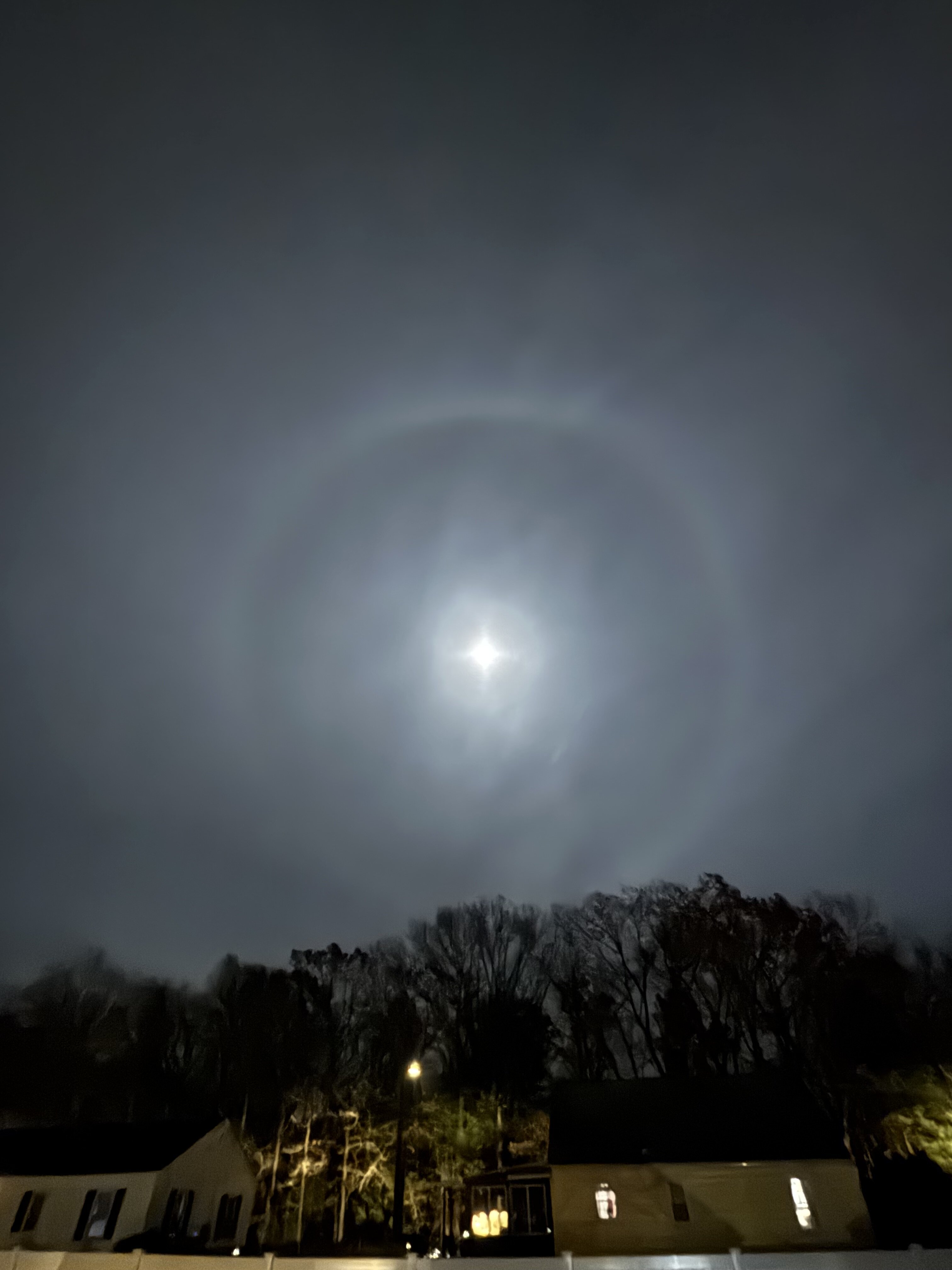
Crazy how vibrant it is...not like the picture is adding effects. -
Blowvember - and not named for wind potential
weatherwiz replied to Go Kart Mozart's topic in New England
Giant halo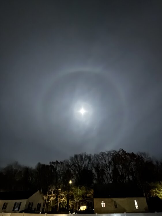
-
Blowvember - and not named for wind potential
weatherwiz replied to Go Kart Mozart's topic in New England
Too many emojis. It takes like an hour to find the right one at the bottom. Pretty soon the length will span the width of the monitor. -
Blowvember - and not named for wind potential
weatherwiz replied to Go Kart Mozart's topic in New England
whole NWS must be having some major issues today -
Blowvember - and not named for wind potential
weatherwiz replied to Go Kart Mozart's topic in New England
Who would have that the area of convection in the far southwest Caribbean would become the main player lol. But I'm not so sure we can really call this one a fail, obviously with no low-level circulation [until yesterday afternoon] guidance is going to really struggle. If that main circulation formed around Jamaica/Cuba (like south of Cuba) where that initial burst of convection occurred, this would be a much different story for Florida, IMO. -
Blowvember - and not named for wind potential
weatherwiz replied to Go Kart Mozart's topic in New England
The brunt of the cold is all bottled up on the other side of the hemisphere. Need to get it to this side, otherwise who cares what the NAO, AO, EPO, PNA, WPO are and what combos you have. Without the combos we are flooded with warmth and with the combos we're barely avg. -
Blowvember - and not named for wind potential
weatherwiz replied to Go Kart Mozart's topic in New England
wow...was looking at the 12z GFS and thought to myself, "oh wow that's a decent cold shot in about 7-10 days" looking at 850/925...was curious as to what the sfc looked like...no cold just somewhat avg times with the most below avg temps across the OV into the SE. -
Blowvember - and not named for wind potential
weatherwiz replied to Go Kart Mozart's topic in New England
Never! But 6 more weeks doesn't sounds too bad when you think of it lol. -
Blowvember - and not named for wind potential
weatherwiz replied to Go Kart Mozart's topic in New England
hmmm maybe Florida gets saved. If center develops where that convection is exploding, this may get disrupted by the Yucatan -
Blowvember - and not named for wind potential
weatherwiz replied to Go Kart Mozart's topic in New England
Fine by me. I was thinking the other night when I was standing outside at like 6:30 or 7:00...it only 6 months it will still be light out with temps in the 90's and dews in the 70's. Almost there -
Blowvember - and not named for wind potential
weatherwiz replied to Go Kart Mozart's topic in New England
FWIW, 12z MET came down to Earth for BOS tomorrow night...has a low into the lower 30's. OTOH, it's going wild at some other places -
Blowvember - and not named for wind potential
weatherwiz replied to Go Kart Mozart's topic in New England
The best thing to probably do is compliment the assessment of D7-10 ensembles and then start assessing how guidance is verifying with the pattern across Asia through the central PAC. If these D7-10 day "pattern changes" have merit, we'll start seeing that in the D3-4 time frame within that region. But then again, when it comes to pattern changes, I guess it depends on what metric someone is using to quantify a pattern change. I mean if we have a pattern with a trough in the west and ridge in the East with a dry east and go to a ridge in the west and trough in the east but still come out dry...that pattern did technically change. -
Blowvember - and not named for wind potential
weatherwiz replied to Go Kart Mozart's topic in New England
It's really wild. I was looking at H5 evolution on the 6z GFS and thought maybe we could see a decent chance for some rain with that cold front around that time frame but looked at the sfc and nope. It's a vigorous trough that digs, unfortunately it becomes a massive, occluded piece of junk which results in the whole system weakening as it moves into the Northeast. Really the whole pattern moving forward seems to favor closed off systems within the mid-west which occlude as they move across the Ohio Valley leaving us with nada. We need a drastic PAC shakeup and probably need a massive shakeup over Europe/Asia (moreso Asia) to get things jumpstarted. -
Blowvember - and not named for wind potential
weatherwiz replied to Go Kart Mozart's topic in New England
Right, I've been thinking about that. That is some pretty brutal luck. I often wonder, if we did not have that massive HP over us when Helene was moving inland, if we would have had some big impact here (assuming Helene would have taken a more eastward track up the coast versus going up the Tennessee Valley). -
Blowvember - and not named for wind potential
weatherwiz replied to Go Kart Mozart's topic in New England
Thinking about winter storm potential. when you're trough is already starting to dig here and your system is still way down there...not happening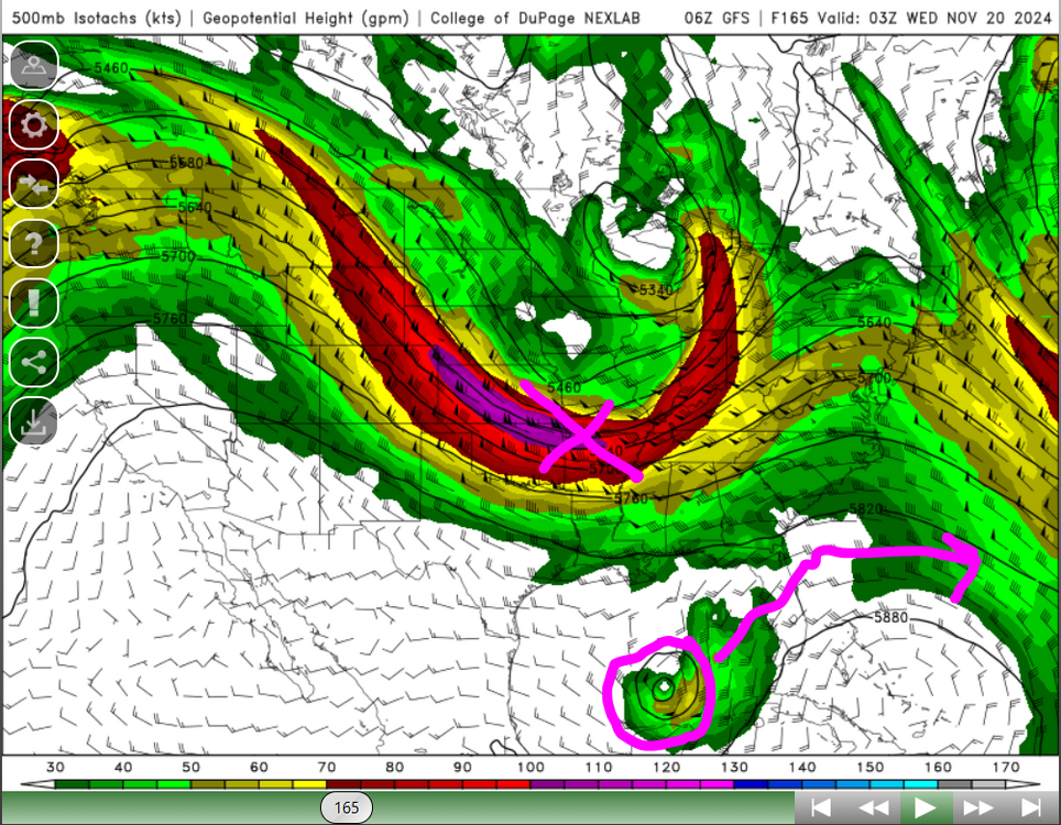
-
Blowvember - and not named for wind potential
weatherwiz replied to Go Kart Mozart's topic in New England
If this does go into Florida (which I think is a pretty good shot, its just a matter of whether its southern Florida or farther north along the coast) this will almost certainly become absorbed by the approaching trough and quickly get shunted east. Not a pattern where a system is captured and slung northwards up the coast. -
Blowvember - and not named for wind potential
weatherwiz replied to Go Kart Mozart's topic in New England
At least based on bufkit, the GFS is lightest with winds but MOS/NBM keep BOS around 10 knots through the night. Even if you look at NAM bufkit at BOS, coldest 2M temp is right around 32 and it doesn't really seem favorable for rad cooling (unless the winds ended up becoming quite lite) but yeah...even if that happens 22 isn't happening. -
Blowvember - and not named for wind potential
weatherwiz replied to Go Kart Mozart's topic in New England
The MET should just be canned. There are situations where it will outperform but 99% of the time its pure garbage...waste of resources really. Maybe not as much around these parts but other areas of the county it can be an absolute embarrassment. I get MOS isn't going to handle anomalous patterns at all but there are some situations it will be like 10-20F below MAV/NBM.