

weatherwiz
-
Posts
81,154 -
Joined
-
Last visited
Content Type
Profiles
Blogs
Forums
American Weather
Media Demo
Store
Gallery
Everything posted by weatherwiz
-

Blowvember - and not named for wind potential
weatherwiz replied to Go Kart Mozart's topic in New England
yeah the clowns were going insane. I got shafted big time here with that band setting up over northern or central Connecticut. That was the white flag for me with winter. But that's what these snow maps do...they truly are ruining the field. They are used all over and everywhere. It's all about hype, ratings, likes, and mentions. Too bad NOAA doesn't have any authority to ban those garbage products from being created. -
Blowvember - and not named for wind potential
weatherwiz replied to Go Kart Mozart's topic in New England
yeah same storm but like Scott said not that dramatic. I forget what some of the forecasts were for Boston but I want to say the consensus forecasts were like 8-12''? -
Blowvember - and not named for wind potential
weatherwiz replied to Go Kart Mozart's topic in New England
This has probably been frustrating above anything else. The model agreement has been dogshit and the ensembles have been just as bad...they've lead to several "high confidence" forecasts for some storms 3-5 days out, and the snowfall forecasts start flying, winter storm watches/warnings start flying, and then everything falls to crap the last minute. Then of course we had the Feb 5(?) debacle where Hartford county went from a winter storm warning to advisory only to get over a foot of snow widespread lol. -
Blowvember - and not named for wind potential
weatherwiz replied to Go Kart Mozart's topic in New England
llvl lows developing and tracking to our south and this is what we can muster up for 925 temps But that is some serious llvl cold behind this...definitely concerned with some degree of suppression, however, we could be in game for clippers.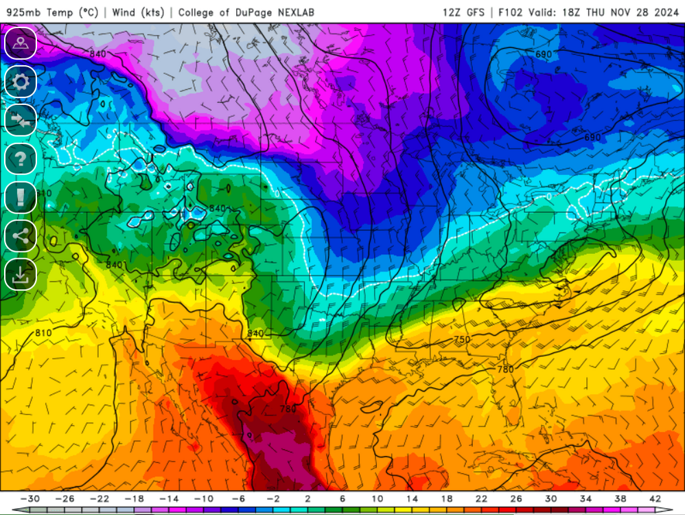
-
December 2024 - Best look to an early December pattern in many a year!
weatherwiz replied to FXWX's topic in New England
There seems to be a degree of spread within the strength of the MJO but perhaps the MJO strength will be too weak to have much of an impact or influence on the overall pattern, especially if that northern PAC domain verifies as is. -
Same...I'm down for the December one, whatever the date is.
-
Blowvember - and not named for wind potential
weatherwiz replied to Go Kart Mozart's topic in New England
west-northwest to northwest flow over waters which I'm sure are still quite warm with 850's -12C to -13C...that would be some wild instability. -
Blowvember - and not named for wind potential
weatherwiz replied to Go Kart Mozart's topic in New England
I would love to experience something like that but I'm fearful I will be airborne -
Blowvember - and not named for wind potential
weatherwiz replied to Go Kart Mozart's topic in New England
Could be some pretty intense LES this weekend...hell could be a pretty prolonged and prolific event. -
Blowvember - and not named for wind potential
weatherwiz replied to Go Kart Mozart's topic in New England
I wonder what its like in the Plains or like Montana when they get big wind events and are sustained 50-60 mph and gusting to 80. That must be fun -
We should also try and do one during the spring
-
December 2024 - Best look to an early December pattern in many a year!
weatherwiz replied to FXWX's topic in New England
I know we don't need southern stream energy to get storms but I would like to see signals of a bit more active southern stream. It is nice seeing a PV lobe (or multiple pieces) hanging around in southeast Canada so the one thing to watch for that is any shortwaves which may swing through our region. If you just look at SLP/QPF maps for storms you can often miss these because sometimes a storm won't "pop up" until like 2-3 days out while the signal where there at H5 for 4-5 days. But we keep that PV energy around and get a southern stream vort to ride the coast... -
Blowvember - and not named for wind potential
weatherwiz replied to Go Kart Mozart's topic in New England
What I'm also worried about too is and this is exactly what you said the other day...now we could run into issues where the vorts are shredded I probably jinxed that because I said the look didn't really seem like something where that would happen. -
Blowvember - and not named for wind potential
weatherwiz replied to Go Kart Mozart's topic in New England
That is one helluva change from 18z versus 12z in that H5 evolution mid-to-late week holy cow. -
Blowvember - and not named for wind potential
weatherwiz replied to Go Kart Mozart's topic in New England
Is the WP the CPC calculates different from the WPO? Trying to get back into this stuff and I vaguely remember discussions from a while back that the two are different. -
Blowvember - and not named for wind potential
weatherwiz replied to Go Kart Mozart's topic in New England
So much attention gets paid to the NAO, but I would much rather have this combo. I would consider this probably a neutral-ish NAO but I feel like if we added a -NAO to this (like a more pronounced -NAO) that could end up screwing us in a couple ways. This is about as perfect of a look you can ask for with cross-polar flow right into our region. Also notice the trough axis...this is vastly different than anything we've seen the last few winters, even the periods where things looked "good"... there were still signals of the trough axis being too far west into the OV which opened the room for cutters. You're not getting a cutter in this look. Also, you get any southern stream energy to phase in with any northern stream energy...you're going to have some big storm potential with the degree of moisture that would be coming from the bath waters of the Gulf. -
Blowvember - and not named for wind potential
weatherwiz replied to Go Kart Mozart's topic in New England
Have some sun breaking through here with some blue sky -
Blowvember - and not named for wind potential
weatherwiz replied to Go Kart Mozart's topic in New England
I gotta say...I am feeling much better than I was, even from a week ago. One big difference between now and the last few winters is we are already building significant cold into western Canada and loading the cold into our source regions. This end of week system does load in that colder air here. One great plus too is that ridging which has been quite strong across the south really breaks down. This was a concern of mine because ant flexing of that ridge would really screw us and yield a favorable pattern for the OV/upper-midwest. IMO, the only way we really get screwed if this pattern does verify is if we end up suppressed and dry...now that can't be ruled out but I think we are going to have some opportunities to at least watch. -
November 21-22 Rain to Snow Disc/Obs SWNE Wake up to 6” ?
weatherwiz replied to Sey-Mour Snow's topic in New England
I wonder if they got any snow on Westside Campus at WestConn -
Blowvember - and not named for wind potential
weatherwiz replied to Go Kart Mozart's topic in New England
This is true...this certainly has potential to set things up behind it. In that pattern behind it we would have two potential ways to get storms 1) Clippers diving southeast 2) Miller B's -
Blowvember - and not named for wind potential
weatherwiz replied to Go Kart Mozart's topic in New England
I hate these stupid setups which are nothing more than just cold fronts moving through with one or multiple waves developing along them. Unless you have latitude or elevation, so much has to go right with these. There is still potential the front/wave are suppressed far enough south to give hope, but the baroclinic zone would almost certainly be just off the coast which is going to about cook anyone outside of far interior/elevation. -
Blowvember - and not named for wind potential
weatherwiz replied to Go Kart Mozart's topic in New England
Going to need things to go just about perfect for Thanksgiving for anyone outside of the interior/higher elevations to get accumulating snow. -
All those game are good with me but I’m also fine with waiting until after the holidays if that will yield a larger turnout
-
Blowvember - and not named for wind potential
weatherwiz replied to Go Kart Mozart's topic in New England
Ahh I misread...but even with tomorrow night...it actually looks even more marginal than late tonight/early tomorrow morning. -
Blowvember - and not named for wind potential
weatherwiz replied to Go Kart Mozart's topic in New England
I think many have a good shot at flakes but I don't know about the hills getting even 1-3...maybe portions of the Berks get 2'' into like that far northwest CT (Norfolk).


