weatherwiz
-
Posts
81,154 -
Joined
-
Last visited
Content Type
Profiles
Blogs
Forums
American Weather
Media Demo
Store
Gallery
Everything posted by weatherwiz
-

December 2024 - Best look to an early December pattern in many a year!
weatherwiz replied to FXWX's topic in New England
This is I find the response lag incredibly intriguing, something like that is pretty much impossible to predict. But we have certainly seen historically where there is that "atmosphere hangover" from the previous ENSO state when entering the opposite ENSO state. It's quite interesting how this occurs because that hangover seems to be more prominent moving into the cool season versus seeing it moreso in the warm season. Maybe it's just because there is more chaos in the cooler season. But any lingering +AAM with the background ENSO state we're in now...this is something that could vastly bust forecasts geared towards significantly warmer and less snowy in the Northeast. I'll take a +AAM with a near neutral or negative neutral ENSO and run. -
December 2024 - Best look to an early December pattern in many a year!
weatherwiz replied to FXWX's topic in New England
Not really sure how much of an influence the MJO will have moving through December really, the MJO signal doesn't appear overly strong and like you said, other factors driving the bus now and will probably outweigh the MJO signal. -
Blowvember - and not named for wind potential
weatherwiz replied to Go Kart Mozart's topic in New England
Heavy frost out there this AM. Let me guess, no frost for Kevin. -
Blowvember - and not named for wind potential
weatherwiz replied to Go Kart Mozart's topic in New England
The good ole days! -
Blowvember - and not named for wind potential
weatherwiz replied to Go Kart Mozart's topic in New England
With my luck I might start acting like the Bruins and not able to get the garbage in the bin -
Blowvember - and not named for wind potential
weatherwiz replied to Go Kart Mozart's topic in New England
Went outside after the first period of the Bruins game to bring in the recycling and garbage...they are coated in ice...even my girlfriends car is coated in ice. Pavement isn't slippery thankfully because I jogged down the driveway -
December 2024 - Best look to an early December pattern in many a year!
weatherwiz replied to FXWX's topic in New England
This just screams a 95 corridor blizzard -
December 2024 - Best look to an early December pattern in many a year!
weatherwiz replied to FXWX's topic in New England
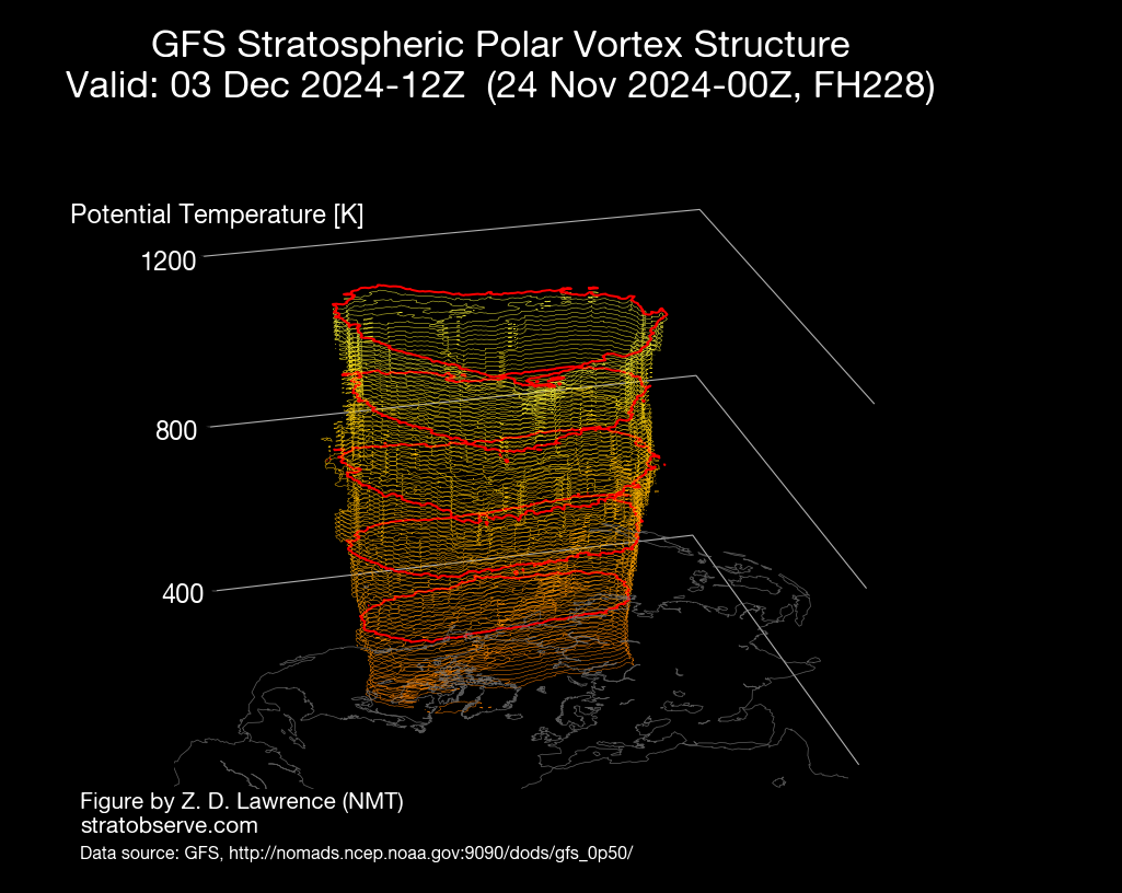
https://www.stratobserve.com/ -
December 2024 - Best look to an early December pattern in many a year!
weatherwiz replied to FXWX's topic in New England
This should help too, no? Looking at this (and other products) the PV does not look very strong and pretty elongated and well into Canada so we should get plenty of energy rotating around, hopefully into our area. (Note: This is just a snap shot from HR 240)
-
December 2024 - Best look to an early December pattern in many a year!
weatherwiz replied to FXWX's topic in New England
Precisely why you can't just look at SLP/QPF maps for storms. -
December 2024 - Best look to an early December pattern in many a year!
weatherwiz replied to FXWX's topic in New England
Love this look, especially because the STJ isn't raging. If the STJ was raging, we would be singing a much different tune. and not a bad thing either...especially since its not a raging strong EL Nino look. This is what I was envisioning we would have seen setup last winter, for a time anyways. -
Blowvember - and not named for wind potential
weatherwiz replied to Go Kart Mozart's topic in New England
Maybe the Boston Bruins should hold a practice in your yard -
Blowvember - and not named for wind potential
weatherwiz replied to Go Kart Mozart's topic in New England
I thought I noticed that this morning on 91 -
December 2024 - Best look to an early December pattern in many a year!
weatherwiz replied to FXWX's topic in New England
December 5th is the May 31 of winter. Makes sense how both those dates have had some notable major weather events around these parts. Both right in the beginning of transition periods. -
Blowvember - and not named for wind potential
weatherwiz replied to Go Kart Mozart's topic in New England
I don't know about that. I mean maybe here on this place, some people don't but I still question that. More times than not storms get hyped up 6-7-8 days out because the snow maps go bonkers and literally 95% of the discussion revolves around the 10:1 and Kuchera maps from 20 different models, 3% of the discussion is actually looking at and applying meteorology, and the other 2% consists of back-and-forth bickering because person A isn't happy with where they are with respect to the storm so cry bust while person B is very happy and calls overperformer because they got crushed. -
Blowvember - and not named for wind potential
weatherwiz replied to Go Kart Mozart's topic in New England
How about we just make our own snow maps!
-
Blowvember - and not named for wind potential
weatherwiz replied to Go Kart Mozart's topic in New England
Agreed, I always thought that some of that stuff was overplayed...like the snow cover in southeast Canada, lack of snow cover on the ground here, etc. Sure there is some influence, but it isn't going to have any bearing on the overall pattern. If the pattern is in place and you have favorable shortwave evolution and interaction, who cares if there is or isn't snow pack across southeast Canada or our region. -
Blowvember - and not named for wind potential
weatherwiz replied to Go Kart Mozart's topic in New England
I guess this could be posted in the December thread, but one thing that hopefully works in our favor moving through the first half of December is a less chaotic flow and pattern which are loaded with shortwaves. A huge part of the reason why guidance has struggled so much, particularly ensembles is the barrage of shortwaves. One model run and one model would highlight one shortwave as the main player while another model choose another and it was just constant flip-flopping. The northern stream should offer us plenty of chances for clippers and/or re-developing clippers off the coast. Looks like we may lose some STJ for a while, which isn't a bad thing at all but once we get a bit of a STJ connection going again, as long as we continue with the troughing signal in the East, we'll open the door for coastals. -
Blowvember - and not named for wind potential
weatherwiz replied to Go Kart Mozart's topic in New England
I'm really not sold on much for this end of the week. It's just a cold front coming through with a weak wave developing along it. There certainly is room for a second wave to develop Thursday night/Friday morning but I don't think its going to be a situation where NNE has any room for snow (reason being QPF will be farther south). It's either going to be rain for SNE or the second wave develops even farther south and we get little QPF, outside of the coast. -
Blowvember - and not named for wind potential
weatherwiz replied to Go Kart Mozart's topic in New England
yeah definitely going to be on the slick side up your way. This is why when I complain about how shitty winter is...I have to remember to indicate I'm talking about down here. Even in the most garbage regimes, you NNE'ers still find way's to get wintry precip -
Blowvember - and not named for wind potential
weatherwiz replied to Go Kart Mozart's topic in New England
Should be a nice little drink for everyone tomorrow. Certainly not enough to cut into the deficit really but something. -
Blowvember - and not named for wind potential
weatherwiz replied to Go Kart Mozart's topic in New England
That could be some serious lake effect snow around Buffalo Saturday with thunder...maybe waterspouts too. Snowadoes comin' -
Blowvember - and not named for wind potential
weatherwiz replied to Go Kart Mozart's topic in New England
Kind of sucks that shortwave is trailing by so much coming across the Lakes. But then again...with our luck any interaction would proably just net cyclogenesis in the HV -
Blowvember - and not named for wind potential
weatherwiz replied to Go Kart Mozart's topic in New England
Nice!! -
Blowvember - and not named for wind potential
weatherwiz replied to Go Kart Mozart's topic in New England
the clouds