

weatherwiz
-
Posts
81,154 -
Joined
-
Last visited
Content Type
Profiles
Blogs
Forums
American Weather
Media Demo
Store
Gallery
Everything posted by weatherwiz
-
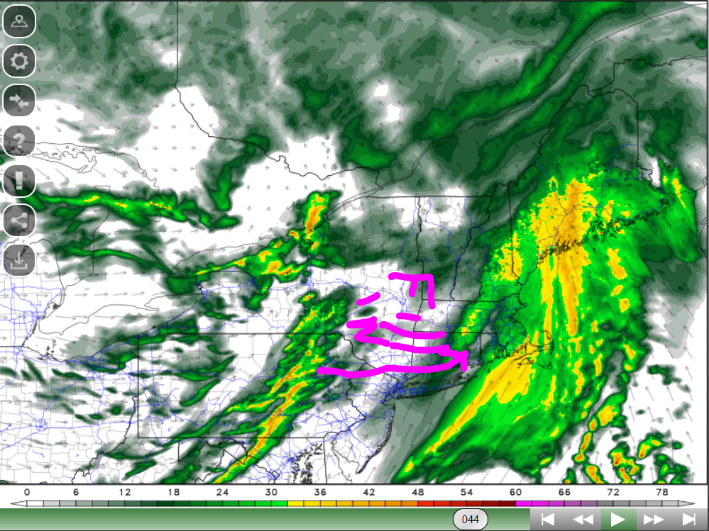
Yeah these are certainly nail bitters. At least at this stage we have expectations for what will occur if the precip shield blossoms on the earlier side and what occurs if it happens to be on the later side. I think in terms of "gradient" from accumulation versus none is pretty set. along 84 is going to be iffy with little-to-any south and east of it. Not much else we can do at this stage with the blossoming aspect...nowcast for that like you said.
-
I think its more of a timing issue than anything else. The system is going to be juiced, its just a matter of how quickly does the precip shield blossom.
-
With at least a quick glance, I'm a little shocked the Euro doesn't have more QPF during that window. Looks like it is just a tad later with blossoming things?
-
Pretty interesting...NAM warms BOS through the overnight and GFS keeps them cold. Pretty big difference in the profile on bufkit nam versus gfs
-
It's the extended HRRR so caution applies, however, this is an intriguing scenario. Develops a squall line which races east and then interacts with the precip shield moving across the eastern part of the region which then allows for snow to blossom region-wide around the AM commute.
-
Like other methods, it accounts for temperature, moisture (relative humidity), but I believe the differentiator is it also factors in upward vertical velocity.
-
Not sure what vendors have for products but cobb method is probably the best to determine snow ratios.
-
ahhh... perhaps, would have to get lucky to be impacted by a snow shower since they'll be scattered but certainly could whiten the ground if lucky to get hit
-
Away from the coast and under the heaviet precip/lift...snow ratios probably a good 12:1-15:1. Using Cobb method and ORH bufkit from NAM ratio is generally like 13:1 it seems...even as high as 16 or 17:1 under best lift
-
I think I have a chance for around 2'' or so. I'm a bit nervous in the valley but I think one thing to watch for tomorrow which could help the valley's is how well do we mix through the day. It's going to get very cold tonight and if we struggle mixing tomorrow we may not see the valley warm too much. Even the mix happy GFS at CEF (bufkit) is barely mid 30's for CEF.
-
I think its going to rip pretty good in Worcester County right into northeast CT just west of where you have some initial BL concerns. Sufficient moisture into the DGZ with some pretty steep lapse rates aiding in instability. I would like to see a bit stronger lift on the RH sounding (at least from 12z NAM but we'll see what 12z GFS has) but I feel pretty confident in a 4-6'' zone and I would not be shocked to see a 7'' report in the highest elevations there (Worcester county). I could see 1.5''/hour rates for a good 2-3 hours...could even get drawn out closer to 4 hours.
-
certainly may be some enhancement across the southern Greens into the northern Berks with the initially due southerly flow
-
Nice shortwave coming through this evening with some mlvl moisture to work with
-
GFS looking juicy...ORH going to get a decent event out of this. Def going to be an area of 4-6''
-
Pretty decent ulvl divergence across the region and you have the nose of an increasing mlvl jet punching into the region along with a strengthening llvl flow (with core along/off the coast). Going to be some good moisture advection into the colder air coupled with enhanced lift from the divergence. We'll see how quickly this all blossoms but I like the NAM's idea of its wetness.
-
Yeah I do think Kevin is going to be on the border initially and that will cut down on totals slightly for him. I'm with you on the 2-3'' for him but I don't think 4-5 can be ruled out.
-
Thought we could see some intense snow squalls up north Thursday but there could be some decent upslope snows in VT
-
I know the SW wind is concerning, but outside of the coast, I think I would hedge towards the colder guidance. If we were climbing into the lower 40's tomorrow inland I think it would be concerning but highs generally look mid 30's. You look too southwest across PA/NJ...that don't get much warmer. So its not like the SW wind is advecting in higher temperatures. Even the llvl warmth is shunted towards SE areas.
-
I think ORH county down to Kevin (or close to Kevin) are going to get a decent hit...thinking there will be a area of 4-6'' within that zone. SE of 84 still in line for at least mixing. Going to be a close call in the question mark spots...it may not take much to cool the sfc and just above given the precip rates.
-
Finally checked out some soundings. Outside of areas south and east of 84 and especially closer to the coast, I don't think warmth at the sfc is going to ne enough to cause concern. Perhaps initially its a mixed ptype, but seems like good upward vertical motion crosses much of, if not, the entire region. Even BDL I think could be in line for 2'' from this. GFS has a good 2-3 hour period of moderate snow at BDL. Something to really watch for Wednesday will be the wet bulbs...looks like wet bulb temps will be into the upper 20's or so. Should have room to cool down to the wet bulb during the evening.
-
Given the SW llvl flow and WAA...I think it's pretty telling that the NAM even keeps mostly everyone except far southeast areas at or below 0 at 925. I haven't looked at any soundings yet so there could be some sneaky warm layers within the llvls but I think the Euro is being a bit too aggressive with the warmth there.
-
Could be some intense snow squalls Thursday for NNE.
-
yeah you're right enough on the line where you have a shot for 1-2''. As we know, snowfall rates can do alot so if we can at least get some signals for a period of heavier precipitation rates that will go along way for marginal areas. That might not be enough though for coastal areas.
-
you have good llvl WAA moving into sub-freezing llvl temps. Elevated areas east certainly in line for some decent accumulations.
-
I think we need to watch for this to really blossom and just in enough time for a narrow zone of heavy snow to impact those areas I mentioned. Have to check out some 12z bufkit soundings for ORH and IJD and see what they show for lift/snow growth.


