weatherwiz
-
Posts
81,152 -
Joined
-
Last visited
Content Type
Profiles
Blogs
Forums
American Weather
Media Demo
Store
Gallery
Everything posted by weatherwiz
-
The Cape is going to get smoked. Wouldn't be surprised to see some 60-70 mph gusts there during the evening.
-
The best winds will probably be from along 91 to Springfield and then north and east. Hi-res guidance is pretty impressive looking with the forced line, you could almost argue that should a line organize, it may not be that low topped. This would probably impact central Connecticut up to about Hartford and then points northeast and east from there. Remember...the line itself will not contain wind, it would be along the leading edge or just ahead of it. Big question though is with so much rain out ahead of it, will it be too stable to maximize gust potential?
-
Time is flying. Pretty soon it will be spring training
-
I'm hoping we get a severe thunderstorm watch tomorrow. Outside of northern New England it would be Severe Thunderstorm Watch: 1 Winter Storm Watch: 0 in meteorological winter hahaha
-
It is quite unstable too...lots of convection embedded...even ahead of the fine line
-
Haven't checked the 0z guidance but I thought we would see a 2% TOR area somewhere...likely northern NJ into SW CT but reading some of the posts that the 0z NAM was a bit east could explain for some of that reasoning.
-
3km NAM with widespread 50-60 knots of wind ahead of the squall line
-
MARGINAL RISK!!!!! Called it...knew it...LET'S GO!!!!!!!! WOOOOOHOOOOOOOO. YESSSSSSSSSSSS

-
There is a little inversion just above the sfc. Probably would limit the gust potential to an extent. Would need convection to maximize gust potential.
-
For sure, definitely increasing confidence for some damaging winds/power outages.
-
Should be getting 12z gfs bufkit soon. Something exciting about waiting for new bufkit profiles
-
I find it interesting that the HRRR/3km NAM appear to be the "warmest" of guidance. 12km NAM is pretty cold though and the GFS is similar to the 12k NAM...I find this pretty telling...sometimes the GFS struggles with the cold tucks so for it to be hitting on it is pretty big IMO.
-
Some interesting differences on the NAM versus GFS and one of the noteworthy differences is temperatures. At 0z Thursday the NAM is mid-to-upper 50's while the GFS is upper 50's to lower 60's. This may not seem like much but that delta could be a big difference in what is realized in wind potential. I would side with the GFS on this and if you put those temps with the NAM's evolution that is a major wind event for most.
-
Holy shit you're right...I see that at 7:00. That would probably be just before the main line would be approaching BOS too. Just checked the 3km and it has a pretty solid line. You may actually see the line strengthen as it moves west-to-east across the region with the enhanced upper support.
-
Just checked 6z GFS for bufkit at BOS...that is pretty wild at 9:00 PM Wednesday night. Though if you toggle the Momentum Xfer from 10 to 1 you can see that it is probably a bit overmixed. My early thoughts with this is we'll see some decent sustained winds across the region but if you're going to want gusts above 50 mph you're going to need the assistance of convection. Without convection the gusts may be difficult to come by (and for what you said...showery stuff stabilizing things). And good note about the wind with lines in these setups...important to understand the strongest winds occur just out ahead of the line and just prior to the arrival of the heavy rains
-
Going to be one heck of a forced line with wind damage.
-

December 2024 - Best look to an early December pattern in many a year!
weatherwiz replied to FXWX's topic in New England
yeah if we see a stronger and deepening low just to our west its game on for some wind wind inland. At least right now though, this could be a huge wind issue towards the coast of Connecticut and eastern New England. IIRC, for coastal areas the strongest winds tend to be just a bit inland away from the water. Though an inversion may not be a huge issue in this one with temps/dews around 60. -
December 2024 - Best look to an early December pattern in many a year!
weatherwiz replied to FXWX's topic in New England
SPC going to have to expand the general thunder line farther north...may even see a marginal risk added. Could see some convectively driven damaging wind gusts potential and even a low end risk for a tornado just to our southwest -
December 2024 - Best look to an early December pattern in many a year!
weatherwiz replied to FXWX's topic in New England
Sounding on the CAPE. That's serious stuff just above the ground Connecticut shoreline just a bit inland -
SNE GTG Banter Thread: Funky Murphy's 1pm 12/14
weatherwiz replied to 40/70 Benchmark's topic in New England
We can make a new thread for January and propose dates...maybe even add in some February too. The earlier the better so people can check schedules, etc. -
December 2024 - Best look to an early December pattern in many a year!
weatherwiz replied to FXWX's topic in New England
Confidence in mid-to-late month has to be extremely low right now. -
December 2024 - Best look to an early December pattern in many a year!
weatherwiz replied to FXWX's topic in New England
That was probably dumb of me yesterday to think there was a shot to see things trend not as warm on the GFS. Anyways, we know inversions can tend to screw us and limit wind potential but if we see sfc temps and dews push 60 and get convection into play...an inversion won't be much of a concern. We'll see how far west and how far inland the wind potential gets but this could be a pretty big deal for eastern sections, especially towards the Cape and coastal Maine. Could be something a little more than our typical cool season wind events. -
December 2024 - Best look to an early December pattern in many a year!
weatherwiz replied to FXWX's topic in New England
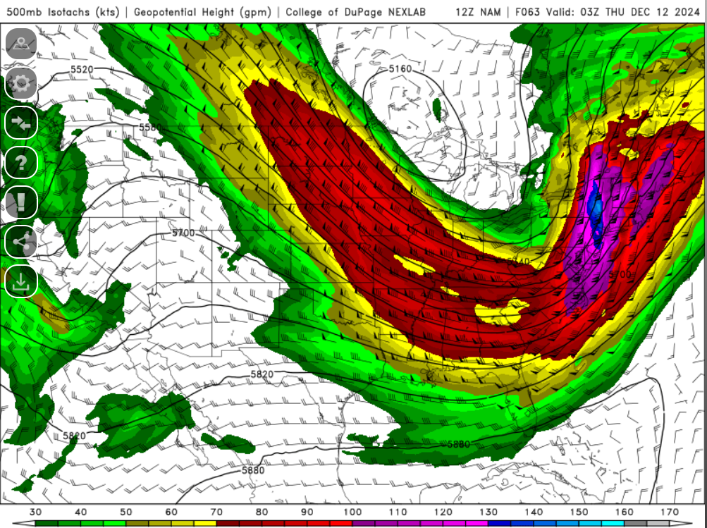
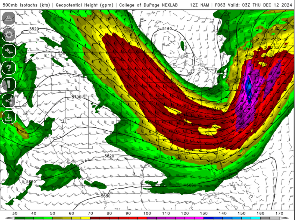
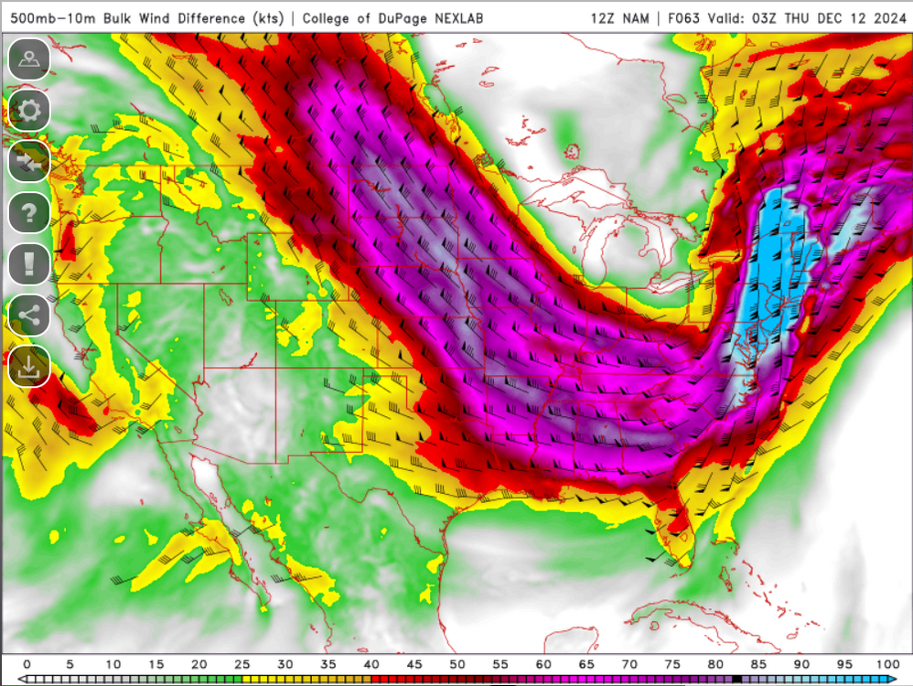
GFS even with a touch of sfc instability (even the NAM). We see dews push 60 and this will be wild. These bulk shear values are insane...nearly 110 knots. Lets get a forced line going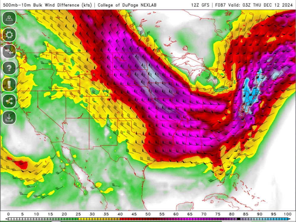
-
December 2024 - Best look to an early December pattern in many a year!
weatherwiz replied to FXWX's topic in New England
I guess I just wouldn't be surprised if we see a bit of a trend towards the warmth not getting as far inland. But I suppose there won't be much to stop warmth from flooding in just south of the warm front. -
December 2024 - Best look to an early December pattern in many a year!
weatherwiz replied to FXWX's topic in New England
I would think the warm front would struggle to propel northwards through the region. The SLP track is a bit too east and also noting the multiple waves developing along it. Probably end up seeing a funky looking sfc warm front.