weatherwiz
-
Posts
79,817 -
Joined
-
Last visited
Content Type
Profiles
Blogs
Forums
American Weather
Media Demo
Store
Gallery
Everything posted by weatherwiz
-

December 2024 - Best look to an early December pattern in many a year!
weatherwiz replied to FXWX's topic in New England
This is great to see, a nice and simple H5 map without a million shortwaves. It's easy to identify what the main player will be Unlike the last several winters where we saw something like this
-
December 2024 - Best look to an early December pattern in many a year!
weatherwiz replied to FXWX's topic in New England
I wouldn't be surprised if this did blossom in time to give eastern areas a chance for something more. This thing could pick up a quite a bit of moisture tracking over the Great Lakes and that is some pretty impressive llvl warm air advection out ahead of it. There is also room for some quick, albeit minor amplification as the shortwave digs across our area evident by a jet streak which tries developing on the western edge of the shortwave. -
December 2024 - Best look to an early December pattern in many a year!
weatherwiz replied to FXWX's topic in New England
Quite intrigued with Wednesday night/Thursday and I know Will, Scott, and a few others highlighted this period about a week ago. Probably even further enhances the weekend potential. -
December 2024 - Best look to an early December pattern in many a year!
weatherwiz replied to FXWX's topic in New England
Not necessarily, not at all. First off, 10:1 is an arbitrary number which is essentially just a made up average. There is no true gauge of what the actual snowfall ratio is. If you get 1'' of QPF and lets say the model accurately predicts that and accurately predicts all snow and then spits out 10'' of snow. If you're snowgrowth and lift is crappy through the duration of the 1''...you're not getting 10'' of snow. -
December 2024 - Best look to an early December pattern in many a year!
weatherwiz replied to FXWX's topic in New England
I would really love to witness some EPIC LES one day. -
December 2024 - Best look to an early December pattern in many a year!
weatherwiz replied to FXWX's topic in New England
Which is dumb, that's not how snowfall or accumulations work. Snowgrowth and cloud processes are extremely important as is the degree of lift into the snowgrowth zone, wind, type of snowflakes (well that goes with snowgrowth) and thermal profile. These factor greatly into the snowfall ratio which also isn't a constant throughout the storm, the snowfall ratio is going to vary and sometimes greatly. You can't just assume ptype and multiply by 10 and none of these fancy algorithms factor in what's most important. -
December 2024 - Best look to an early December pattern in many a year!
weatherwiz replied to FXWX's topic in New England
Incorrect x10000000000000 -
December 2024 - Best look to an early December pattern in many a year!
weatherwiz replied to FXWX's topic in New England
The lake effect snow is going to be epic -
Turkey Day Birch Bender Snow Storm/Observation Thread 11/28/-11/29
weatherwiz replied to dryslot's topic in New England
For sure. You also have H7 developing and closing off just off the Maine coast as the system is lifting northeast. I wouldn't be shocked if there are some 15-16'' totals -
Turkey Day Birch Bender Snow Storm/Observation Thread 11/28/-11/29
weatherwiz replied to dryslot's topic in New England
There is going to be one heck of a narrow fronto band. Someone is going to get smoked. Wouldn't be surprised to see a narrow strip of totals around 12'' from interior Maine southwest into central New Hampshire. -
December 2024 - Best look to an early December pattern in many a year!
weatherwiz replied to FXWX's topic in New England
Yup...this. Definitely signs for this and not an overpowering one. It's pretty crazy how all of the cards seem to be lining up. Big change from the last few years...we're actually seeing subtle changes occur in real time, it's not like all of this stuff is and stays beyond D10. -
December 2024 - Best look to an early December pattern in many a year!
weatherwiz replied to FXWX's topic in New England
This is I find the response lag incredibly intriguing, something like that is pretty much impossible to predict. But we have certainly seen historically where there is that "atmosphere hangover" from the previous ENSO state when entering the opposite ENSO state. It's quite interesting how this occurs because that hangover seems to be more prominent moving into the cool season versus seeing it moreso in the warm season. Maybe it's just because there is more chaos in the cooler season. But any lingering +AAM with the background ENSO state we're in now...this is something that could vastly bust forecasts geared towards significantly warmer and less snowy in the Northeast. I'll take a +AAM with a near neutral or negative neutral ENSO and run. -
December 2024 - Best look to an early December pattern in many a year!
weatherwiz replied to FXWX's topic in New England
Not really sure how much of an influence the MJO will have moving through December really, the MJO signal doesn't appear overly strong and like you said, other factors driving the bus now and will probably outweigh the MJO signal. -
Blowvember - and not named for wind potential
weatherwiz replied to Go Kart Mozart's topic in New England
Heavy frost out there this AM. Let me guess, no frost for Kevin. -
Blowvember - and not named for wind potential
weatherwiz replied to Go Kart Mozart's topic in New England
The good ole days! -
Blowvember - and not named for wind potential
weatherwiz replied to Go Kart Mozart's topic in New England
With my luck I might start acting like the Bruins and not able to get the garbage in the bin -
Blowvember - and not named for wind potential
weatherwiz replied to Go Kart Mozart's topic in New England
Went outside after the first period of the Bruins game to bring in the recycling and garbage...they are coated in ice...even my girlfriends car is coated in ice. Pavement isn't slippery thankfully because I jogged down the driveway -
December 2024 - Best look to an early December pattern in many a year!
weatherwiz replied to FXWX's topic in New England
This just screams a 95 corridor blizzard -
December 2024 - Best look to an early December pattern in many a year!
weatherwiz replied to FXWX's topic in New England
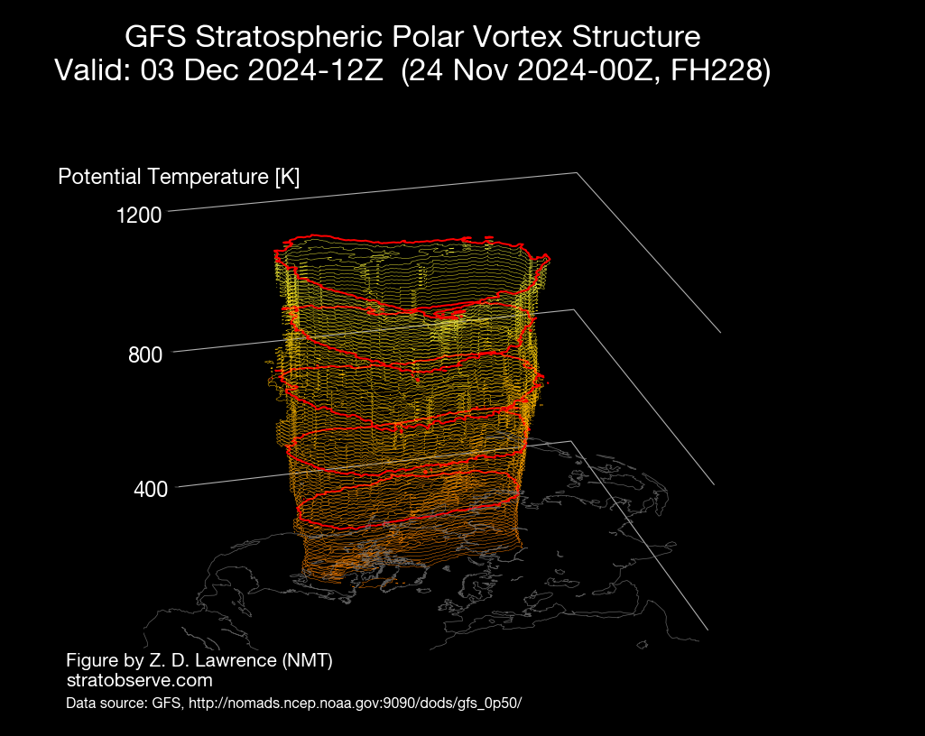
https://www.stratobserve.com/ -
December 2024 - Best look to an early December pattern in many a year!
weatherwiz replied to FXWX's topic in New England
This should help too, no? Looking at this (and other products) the PV does not look very strong and pretty elongated and well into Canada so we should get plenty of energy rotating around, hopefully into our area. (Note: This is just a snap shot from HR 240)
-
December 2024 - Best look to an early December pattern in many a year!
weatherwiz replied to FXWX's topic in New England
Precisely why you can't just look at SLP/QPF maps for storms. -
December 2024 - Best look to an early December pattern in many a year!
weatherwiz replied to FXWX's topic in New England
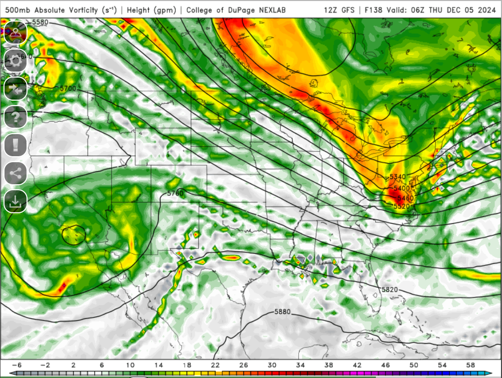
Love this look, especially because the STJ isn't raging. If the STJ was raging, we would be singing a much different tune. and not a bad thing either...especially since its not a raging strong EL Nino look. This is what I was envisioning we would have seen setup last winter, for a time anyways. -
Blowvember - and not named for wind potential
weatherwiz replied to Go Kart Mozart's topic in New England
Maybe the Boston Bruins should hold a practice in your yard -
Blowvember - and not named for wind potential
weatherwiz replied to Go Kart Mozart's topic in New England
I thought I noticed that this morning on 91 -
December 2024 - Best look to an early December pattern in many a year!
weatherwiz replied to FXWX's topic in New England
December 5th is the May 31 of winter. Makes sense how both those dates have had some notable major weather events around these parts. Both right in the beginning of transition periods.