

weatherwiz
-
Posts
81,083 -
Joined
-
Last visited
Content Type
Profiles
Blogs
Forums
American Weather
Media Demo
Store
Gallery
Everything posted by weatherwiz
-
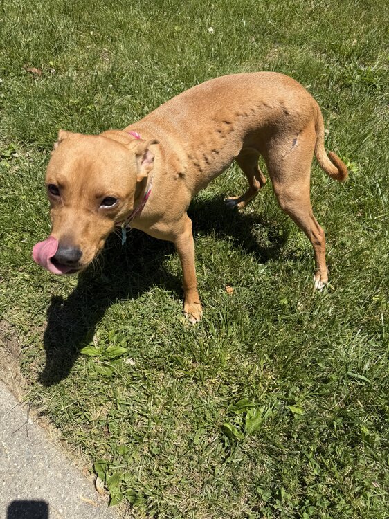
Has anyone seen this happen with a dog before? Her fur is like bubbled up. She doesn’t seem in any pain or distress. Can’t feel anything on her skin
-
All the snow weenies care about are 10:1 and Kuchera
-
Signs were there for this I think. PVA streaming from the north and still pretty cold at 500
-
At least right now, nothing screams the developing EL Nino is a modoki, if anything it looks like we would be looking at a mixed or basin wide event given the strong anomalies in the (hostile) 1.2 region and Nino 4 region. Now, what would happen towards the end of the EL Nino event is a transition to a modoki EL Nino, which isn't uncommon for a weakening stronger EL Nino as region 1.2 tends to be the first to cool. In terms of impacts on the continental U.S. summer, Tip and I had some dialogue on this a few weeks back but I don't think there is much of a correlation and there are drivers. EL Nino's tend to not become fully established until late summer or even early Fall. An argument can be made that while the PAC is in the transitioning mode and this may have a quick and direct impact on the Hadley Cell but there atmospheric response can be quite often lagged to how the ocean is evolving and there are other factors to consider. Also, if we're just focusing on the impacts on summer to stronger EL Nino events, the sample size really isn't that great and at this point a strong event isn't even guaranteed. While the data may indicate that, we still need to get there first. IMO, I think some of the late winter/early spring responses within the Arctic and stratosphere held so much weight on the northern hemisphere pattern that we're still dealing with those impacts.
-
Weekend is going to be all about the warm front. I would not be surprised if guidance is a bit too hung up with the warm front and at least southern areas end up in the warm sector. But not a good sign when you see the sfc low weaken as it crosses the Great Lakes region. That's a good way to stall the warm front or transition it to a stationary front and we never truly warm sector and end up cool with clouds/showers. Uncertainty high for sure weekend and early next week...potential is there to get quite warm but need things to work out
-
Did anyone hear the boom? I did not
-
This is true
-
Just came back from Dunkin. Debated on pulling out the winter hat before I left.
-
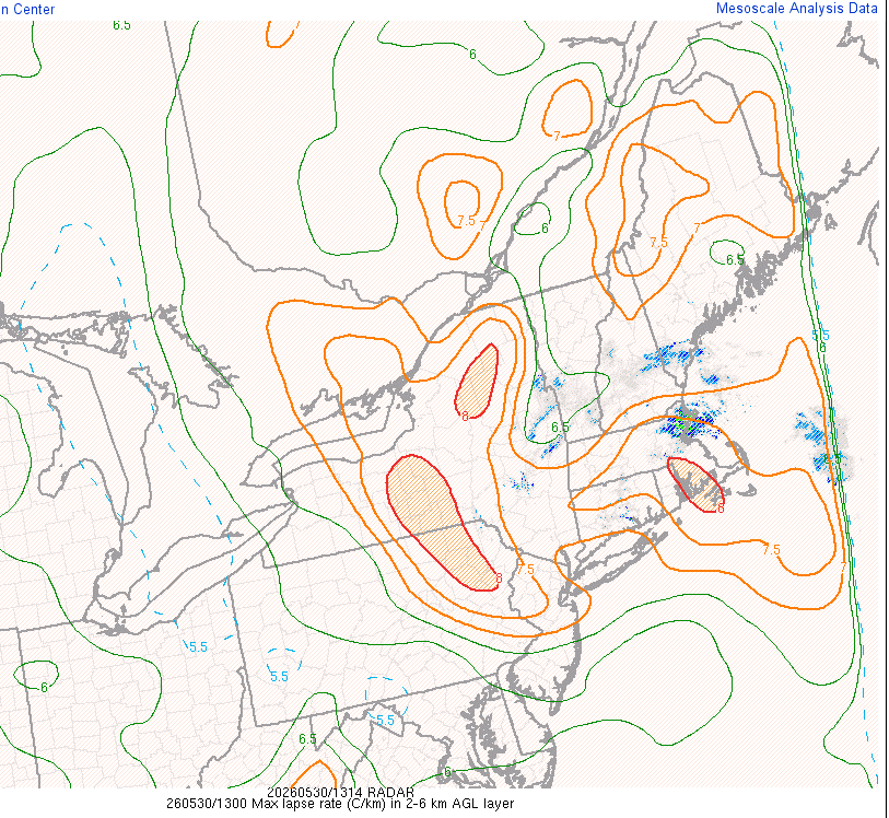
Quite breezy out there. Going to be an interesting over the next 3-5 hours out east when the LLJ maximizes with 2-6km lapse rates as steep as they are
-
llvl lapse rates may be steep enough to support gusts 35-40 mph inland. Also, the lack of rain farther inland and even potential for some cloud breaks may allow better than expected mixing (evident by the steep llvl lapse rates)
-
At least on Monday we should get some cold pool small hailers
-
The second half of June has potential to be hot and humid and more consistent heat/humidity too
-
Time to drop by and share a few of these
-
Just pick me up, turn me upside down, stick my head in the toilet, and repeatedly flush...don't stop flushing
-
Impressive because the NBM tends to underdo wind gusts, though that may have been corrected some with v5
-
although maybe some cold pool storms early next week
-
Can't believe its looking like another dud for the first two weeks of June for my friend and I. We had done the final week of May and first week of June from like 2009 until like 2019 then didn't get together the covid year and then bumped to the first two weeks of June. We used to have pretty solid success until recently which is why we moved back a week. Well at least during my second week of vacation is when summer classes start so I guess I can use that to try and work ahead
-
The word perfect should reserved for days when it is 98/76 and overnight temperatures hover 73-77. That is perfection.
-
This weekend is likely more just showers versus a widespread steadier rain. There will probably be a narrow axis, however, where there is some steadier/heavier rain but that will likely be confined to somewhere in NNE.
-
But drought!!!
-
What a recovery…total 180 from the morning. Pretty awesome outside
-
Southington is def not SW CT I wouldn't even consider Waterbury as being in SW CT...probably more so getting towards Southbury
-
Heat kicked on this morning
-
Don’t speak that into existence
-
In Enfield at my nieces for a cookout. Absolutely awful out. Wish when ours have held onto the weather we had in the morning. Wasn’t great but better than this


