weatherwiz
-
Posts
80,203 -
Joined
-
Last visited
Content Type
Profiles
Blogs
Forums
American Weather
Media Demo
Store
Gallery
Everything posted by weatherwiz
-

“Cory’s in NYC! Let’s HECS!” Feb. 22-24 Disco
weatherwiz replied to TheSnowman's topic in New England
That is going to absolutely crush from BOS down through Hartford into Southwest CT -
“Cory’s in NYC! Let’s HECS!” Feb. 22-24 Disco
weatherwiz replied to TheSnowman's topic in New England
That is going to be some absolutely epic banding
-
“Cory’s in NYC! Let’s HECS!” Feb. 22-24 Disco
weatherwiz replied to TheSnowman's topic in New England
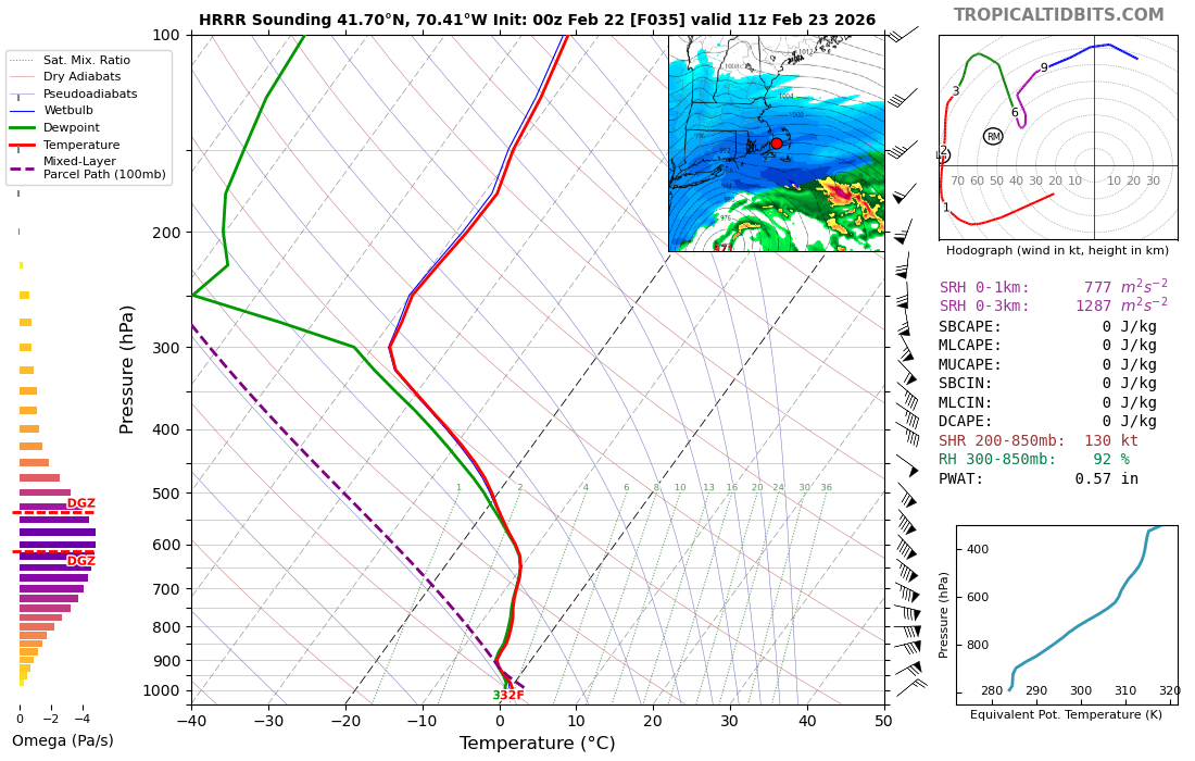
Absolutely salivating looking around at soundings. This one is New Haven, CT from 6z NAM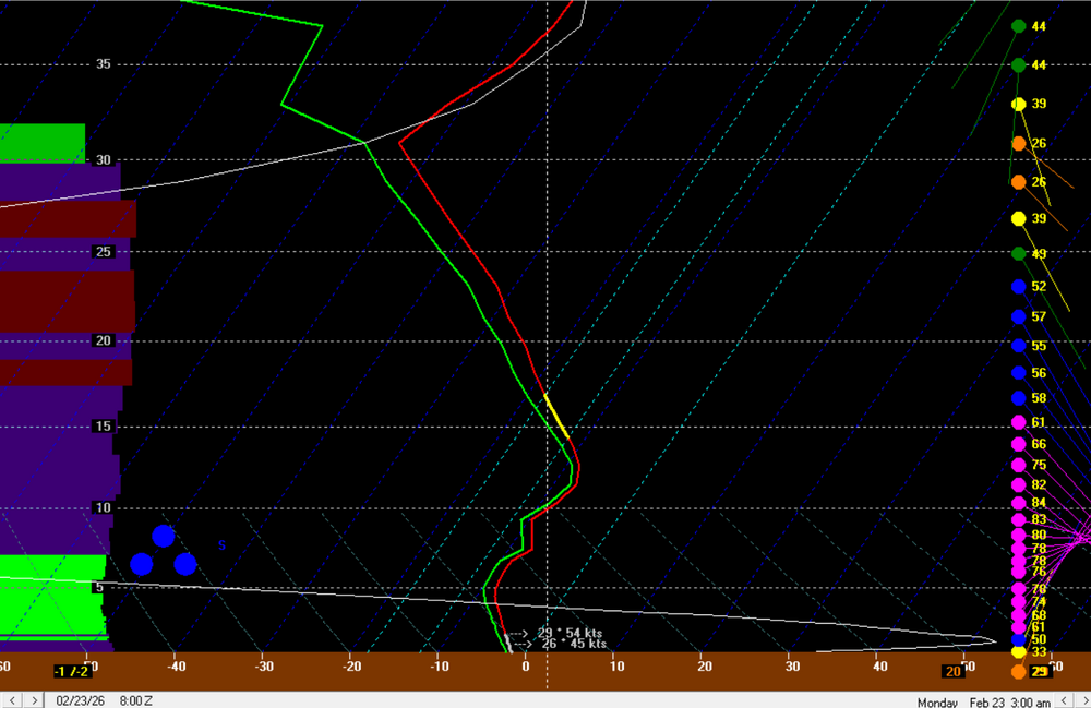
-
“Cory’s in NYC! Let’s HECS!” Feb. 22-24 Disco
weatherwiz replied to TheSnowman's topic in New England
General line expanded north!!!!
-
“Cory’s in NYC! Let’s HECS!” Feb. 22-24 Disco
weatherwiz replied to TheSnowman's topic in New England
That happened to me once I think in 2008. We were having a morning severe event (I think it was the day of the Swanzey, NH F2. I stayed up for like 2 days in a row excited for that morning and fell asleep as things were starting and I missed 1"+ hail at my house -
“Cory’s in NYC! Let’s HECS!” Feb. 22-24 Disco
weatherwiz replied to TheSnowman's topic in New England
I don't know if any of us can go that long without seeing the SREFs -
“Cory’s in NYC! Let’s HECS!” Feb. 22-24 Disco
weatherwiz replied to TheSnowman's topic in New England
Ahhh yes I see it now. -
“Cory’s in NYC! Let’s HECS!” Feb. 22-24 Disco
weatherwiz replied to TheSnowman's topic in New England
My initial thought was something along those lines but the soundings are absolutely nuts. Kind of reminds me of 2013 when we were seeing radar returns like that but it was all snow
-
“Cory’s in NYC! Let’s HECS!” Feb. 22-24 Disco
weatherwiz replied to TheSnowman's topic in New England
This is absolutely disgusting on the Cape. That's 40+ dbz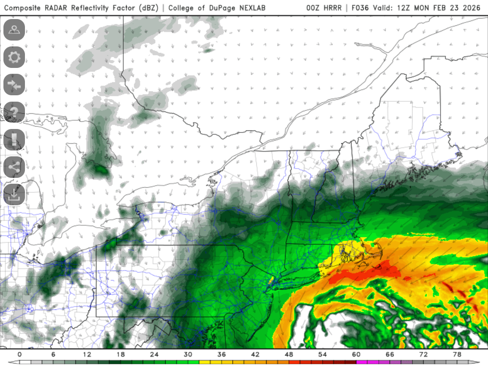
-
“Cory’s in NYC! Let’s HECS!” Feb. 22-24 Disco
weatherwiz replied to TheSnowman's topic in New England
ka-boom
-
“Cory’s in NYC! Let’s HECS!” Feb. 22-24 Disco
weatherwiz replied to TheSnowman's topic in New England
the banding -
“Cory’s in NYC! Let’s HECS!” Feb. 22-24 Disco
weatherwiz replied to TheSnowman's topic in New England
I still think the models are breaking that down a bit too quickly -
“Cory’s in NYC! Let’s HECS!” Feb. 22-24 Disco
weatherwiz replied to TheSnowman's topic in New England
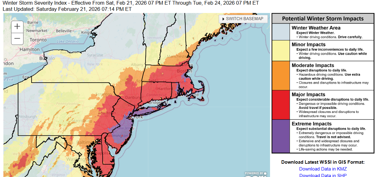
Gotta show some love to the WSSI
-
“Cory’s in NYC! Let’s HECS!” Feb. 22-24 Disco
weatherwiz replied to TheSnowman's topic in New England
Talk dirty to me and whisper slowly next to me ear -
“Cory’s in NYC! Let’s HECS!” Feb. 22-24 Disco
weatherwiz replied to TheSnowman's topic in New England
Exactly!! I absolutely believe there will be some 4"+ per hour rates -
“Cory’s in NYC! Let’s HECS!” Feb. 22-24 Disco
weatherwiz replied to TheSnowman's topic in New England
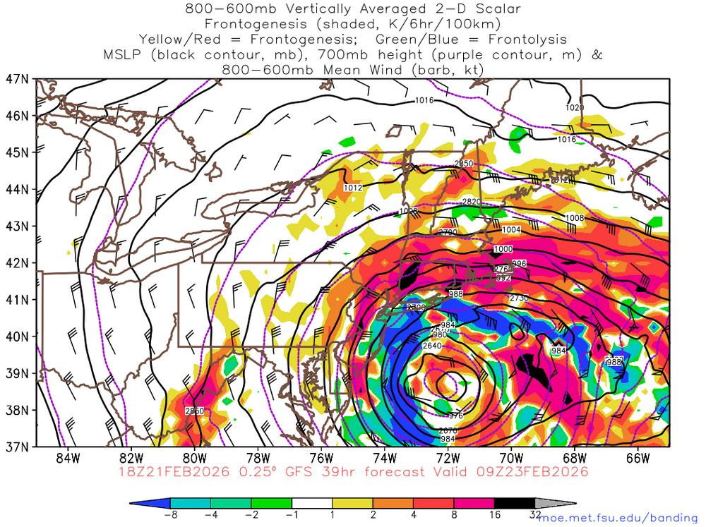
Ultimately, I would really like to start seeing more signals for a pivot and maintaining of this intense fronto to really get excited and hopeful for widespread 18-24" but its more a quick south to north push and then it kind of fizzles. I think though there are signals which argue for that to occur and I wouldn't totally expect models to accurately handle this right now. But anyways...it is going to be absolutely epic for some hours. 18z NAM 18z GFS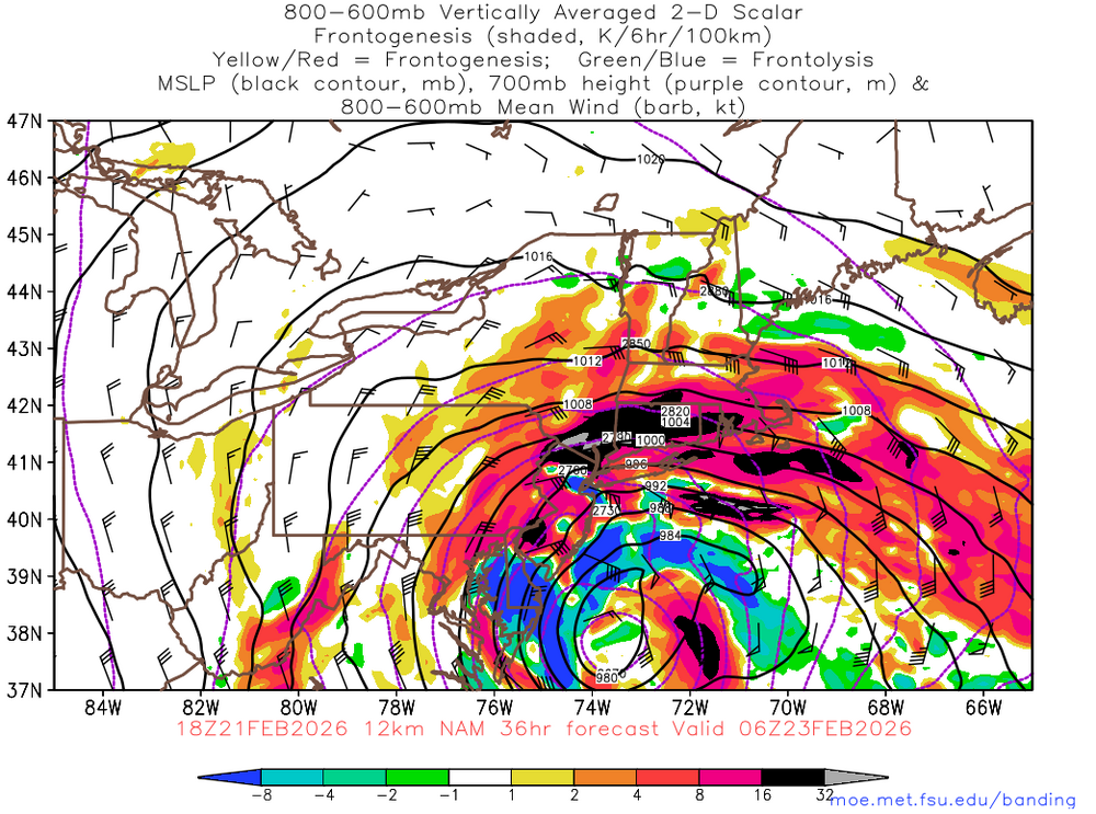
-
“Cory’s in NYC! Let’s HECS!” Feb. 22-24 Disco
weatherwiz replied to TheSnowman's topic in New England
This. Gotta be very careful with using QPF charts to diagnose banding. Intuitively it makes sense but this is where you have to look at mid-levels, how they're evolving, and how they're tracking. And with this that is part of why I think 18z GFS QPF is a bit underdone -
“Cory’s in NYC! Let’s HECS!” Feb. 22-24 Disco
weatherwiz replied to TheSnowman's topic in New England
I'm greedy and want/hoping for 2 feet even though I'm not getting it. Getting 2 feet would get me ~40" from 100 and then hopefully cut that to 20" end of the week -
“Cory’s in NYC! Let’s HECS!” Feb. 22-24 Disco
weatherwiz replied to TheSnowman's topic in New England
I wouldn't be surprised if the GFS was actually a bit too low with QPF, especially along the QPF gradient (like Ray alluded too earlier) but too me it seems the GFS is way too quick in shutting down the CCB. I know the system has occluded but its shutting things down a bit too quickly with 850mb winds coming in at 50-60+ knots. Yeah its more of a northerly component but there is still a moisture fetch from the Atlantic. -
“Cory’s in NYC! Let’s HECS!” Feb. 22-24 Disco
weatherwiz replied to TheSnowman's topic in New England
I don't think that's chasing convection there. Just kind of a quick glance but at least one thing it looks like is it isn't as clean with the injection of all the shortwave energy on the backside. -
“Cory’s in NYC! Let’s HECS!” Feb. 22-24 Disco
weatherwiz replied to TheSnowman's topic in New England
Yeah it is a bit further south and east...I was just thinking it was noise but next few frame was definitely more than just noise. I think from here on out its really going to be about focusing on the CCB and how it evolves and does it pivot and where so...thats where we're going to probably see 2"+ QPF. Even though the valley shows less for QPF (especially just north in MA I don't think you can totally rule out the valley getting clobbered or even a scenario where the heaviest banding actually pivots across the valley -
“Cory’s in NYC! Let’s HECS!” Feb. 22-24 Disco
weatherwiz replied to TheSnowman's topic in New England
GFS pretty steadfast at 18z...excellent to see. -
“Cory’s in NYC! Let’s HECS!” Feb. 22-24 Disco
weatherwiz replied to TheSnowman's topic in New England
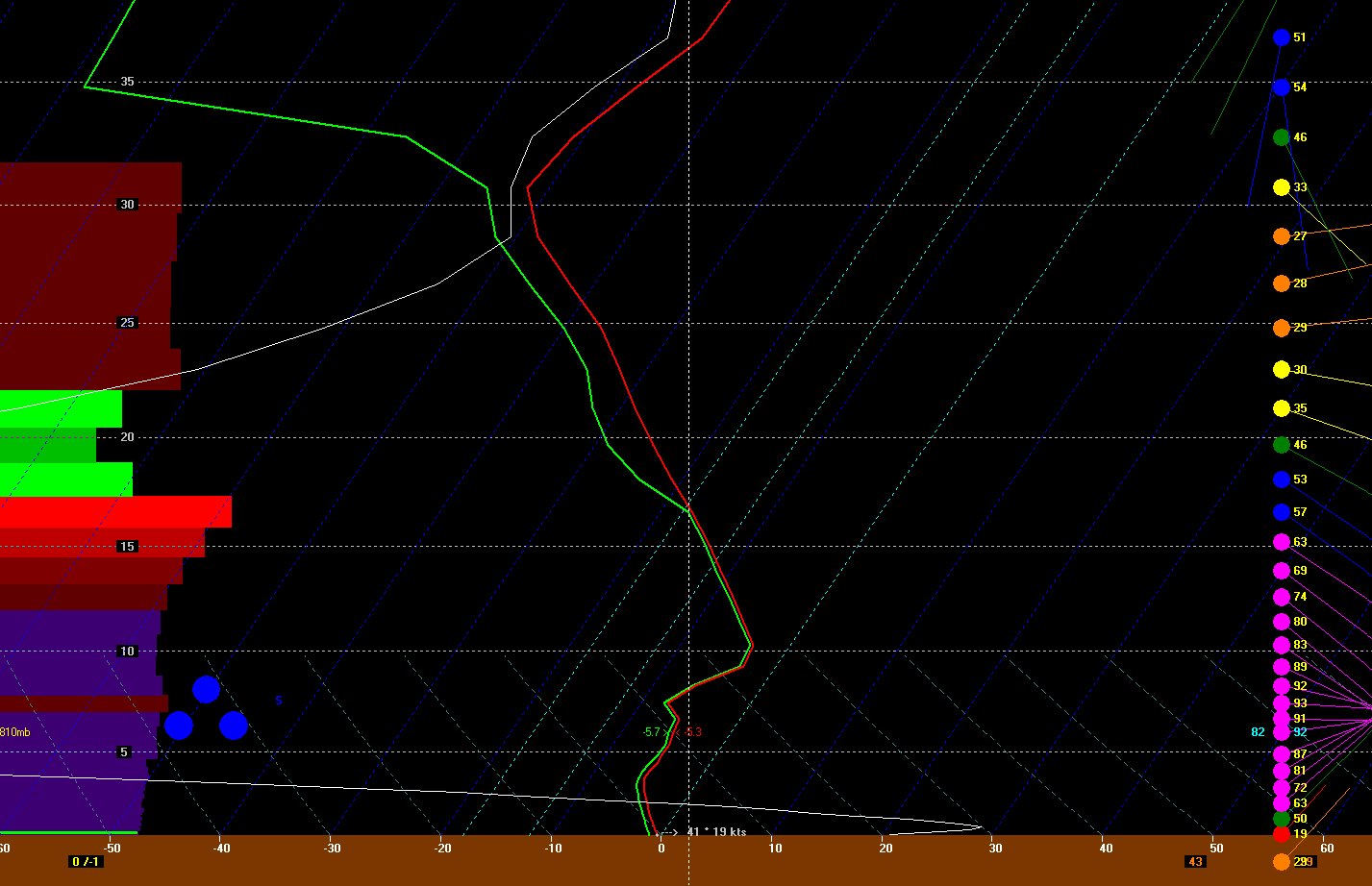
18z NAM bufkit for Groton, CT check out that lapse rate from 700-500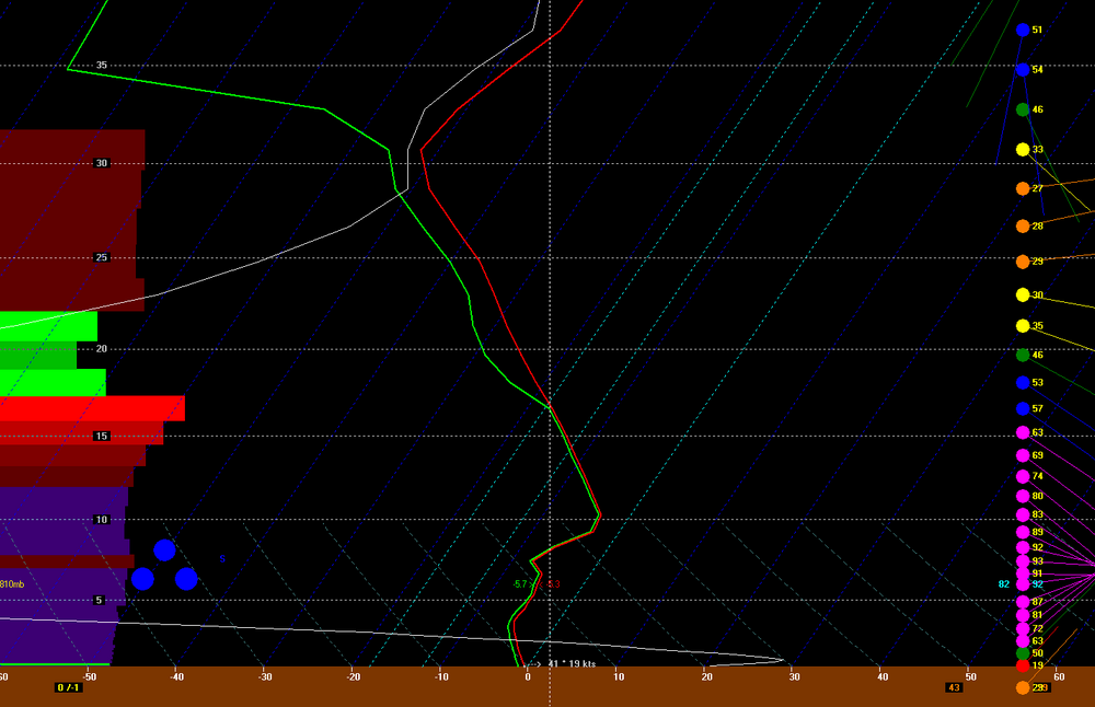
-
“Cory’s in NYC! Let’s HECS!” Feb. 22-24 Disco
weatherwiz replied to TheSnowman's topic in New England
This is way too excited. I have a quiz I have to get done by tomorrow night...not sure how I'll have the attention span to do that. I can't even concentrate enough walking to the bathroom. I just want to click on different forecast soundings and bufkit and stare...just click, view, click, view....too many soundings, too little time -
“Cory’s in NYC! Let’s HECS!” Feb. 22-24 Disco
weatherwiz replied to TheSnowman's topic in New England
I noticed looking around at bufkit that seemed to be a thing and because of it alot of the highest omega was above it. Hope not some sort of issue. I tried not to think it about too much because sometimes I think I get too carried away