

yoda
-
Posts
63,562 -
Joined
Content Type
Profiles
Blogs
Forums
American Weather
Media Demo
Store
Gallery
Everything posted by yoda
-
https://www.wpc.ncep.noaa.gov/discussions/hpcdiscussions.php?disc=qpfhsd Afternoon winter disco from 237pm
-
RLX issued warnings for their zones bordering the LWX CWA just now
-
@MillvilleWx I'm going to assume another conference call tonight for upgrades to warnings in tomorrow mornings package for PHL/AKQ/LWX/CTP?
-
-
I posted the snow squall warnings in the jan 3 thread btw. Cold weather advisory replaced wind chill advisory
-
geez 183 for you guys
-
Well that escalated quickly
-
gets sheared out looks like IMO
-
12z CMC is a big hit -- all snow DC metro... prob EZF as well
-
800mb is barely over the line FWIW, everything else is 0c or lower @nj2va shows it better above
-
I would posit that as long as the precip doesnt get too light, it should remain snow since the "nose" is only a few tenths above 0c
-
-
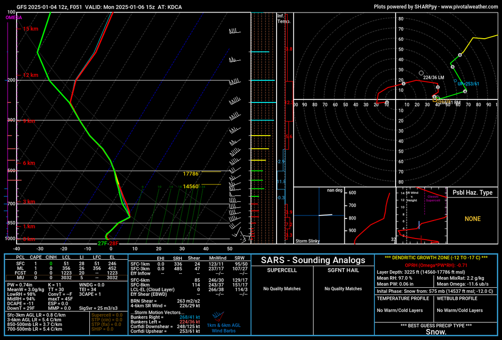
DCA metro is snow at 15z MON... barely. if its light precip, sleet will possibly mix in. warm nose is near 800mb... but 0.5c at most
-
06z GFS was a major hit for almost everyone... hopefully the 12z GFS can continue that
-
Pretty cool to see freezing rain in the FL panhandle though
-
very southern slider
-
I hope so. 4" would be nice. Would be nice for one of those unicorn storms we all could enjoy
-
RGEM is less tbh
-
ICON has 2" for PHL...
-
12z ICON moved its heaviest snow totals out of MD... DC near 6" with Kuchera
-
UKIE is. 12z ICON did move its snow totals south this run though
-
12z RGEM also nothing like 12z NAM... is a hit
-
DC metro is all snow on 12z ICON through 18z MON
-
Heavy snow knocking on the door of DC metro at 06z MON on 12z ICON


