

BlizzardNole
-
Posts
2,818 -
Joined
-
Last visited
Content Type
Profiles
Blogs
Forums
American Weather
Media Demo
Store
Gallery
Everything posted by BlizzardNole
-
One of us three desert rats has to get lucky at some point! Got a small t-storm moving due east toward me....but usually they get pulled up along the high elevations in the NW part of the county towards Damascus. We'll see
-
A big 0.15 for the desert! Better than nothing I guess Sorry in advance but what my area needs is a tropical storm landfall in the NE gulf which tracks slowly up the east coast. I'll need some of you to take one for the team and deal with 8-10 inch amounts so that I can get a 2" rainfall.
-
Wait, you moved back to Stephens City? Watching that line coming through Loudoun and hoping, but I also know what west-to-east usually means for my rain shadow
-
Just did some garden work and (of course) some watering. Even though it's only about 80 degrees it is HUMID! There's a crew doing a roof a couple doors down. Those guys gotta be sweating bullets
-
Got that right! Snowless winter followed by drought, smoke and consistently missing every good rains in every direction. I hope the luck changes for my area. I'd be happy to see ONE good thunderstorm this month.
-
So you're saying my 0.8 for the last 10 days has not ended my drought? Dadgummit! I'd like to see an early tropical system come into the FL panhandle and ride slowly up the coast while being squeezed by a cold front.
-
Congrats to folks getting the big stuff. Got 0.20 here which is better than we've had in a while
-
Caught a quick shower as the line was forming overhead but congrats eastern MoCo and Howard as it's turning into a decent line. Wish it had formed just a little further west
-
LWX discussion of thunderstorms in a nutshell: today east of I-95; Saturday west of blue ridge. The Drought of '23 rolls on
-
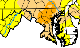
Oooh good point on the car filters. Oh and new drought map still reflects severe -- I bet my little micro-desert qualifies as extreme as I've had less than 1.5 for June
-
Check your AC filters after the smoke clears. We replaced our filter in April and it's one of those 4-inch thick ones that's supposed to last up to a year. We had an annual AC checkup last week and ours was dark gray already, like it had been in a whole year. It was that smoke event from early June. One of my friends had just changed his in late March and it was almost black. 82 and sickly yellow sun, AQI 175
-
For some of us, let's hope those chances turn out better than the last two weeks! I'm on track to finish well under 2 inches for the month. Closest CoCoRaHS (a little south) has 1.84 and I know they caught a couple that I missed. There's a 3.42 that is just 4.2 miles to my ESE
-
Never thought we'd be nearing July and rooting for southerly winds rather than a cool NW flow! Give me a Bermuda high please
-
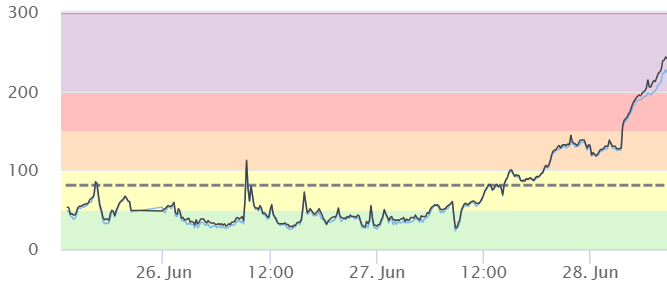
Some 200-plus purple alert readings in SW PA and we have NW winds thru tomorrow Hoping the S winds starting Thursday nights helps quickly. This is from west of Johnstown
-
It'll be interesting to see the update map on Thursday. I was already in the severe drought area and my spot missed out on almost ALL of the rain, including last Friday, yesterday and today. I'm thinking my micro-desert might be getting close to extreme drought soon, since we have no chances of rain any time in the near future
-
We demand the re-distribution of rain! I see our next fail in the forecast: Friday night thru Sunday night with 60-70% chances of rain. Calling it now NOPE
-
It's amazing seeing the same places get pounded over and over while other places get nothing. Zip here again
-
A little sticky at 75/66. I see the point/click forecast has 90% rain chances later today again. Haha yeah right like yesterday's 90%? I'm thankful for my sprinkler heads so I can easily water the garden beds every few days. I've let the grass go dormant
-
2023 Mid-Atlantic Severe Wx Thread (General Discussion)
BlizzardNole replied to Kmlwx's topic in Mid Atlantic
Well damn we just had to cancel our mid-July trip to Marco Island, FL due to family stuff -- there went my one chance to see some thunderstorms this summer- 2,785 replies
-
- 2
-

-
- severe
- thunderstorms
- (and 3 more)
-
Shocked! Nah, I had my sprinklers running by 5. I chuckled when reading forecasts of big t-storms and 90% rain chances. And LOL at that WPC 7-day precip forecast with 3-4 inch rain amounts from a few days ago It will take until Labor Day to reach 3 inches
-
2023 Mid-Atlantic Severe Wx Thread (General Discussion)
BlizzardNole replied to Kmlwx's topic in Mid Atlantic
Wow that looks like storm chaser video from a hurricane- 2,785 replies
-
- 1
-

-
- severe
- thunderstorms
- (and 3 more)
-
Full overcast here now, 88/68. The cloudiness will help with the heavy watering I'll be doing later this afternoon
-
I know what you mean, NPZ. I'm in a rain shadow with high elevations from my W around to the NE. Thunderstorms regularly break up or split around as they descend towards here, then reform just east. I expect the same tomorrow and will be surprised to see more than a couple tenths of rain. My parched lawn HAD to cash in with that strat rain this past week and missed all the heavy stuff, some within a handful of miles. Got nickel and dimed to less than an inch total.
-
Ooof. Although further away, the KIAD radar looks OK for the Annp Balt area. I've been using that one (to watch other people's rain LOL)
-
I just can't believe so much rain is falling so close to the east. The other night it was just west. After today it's relying on thunderstorms so forget about it. We won't see a drop from those so we're done. Guess I'll be watering again this weekend
