

jaxjagman
-
Posts
9,045 -
Joined
-
Last visited
Content Type
Profiles
Blogs
Forums
American Weather
Media Demo
Store
Gallery
Everything posted by jaxjagman
-
But anyways what it seems to me is the MJO is headed towards the WH.AFRICA and possibly strenghten,patterns like this in a declining Nina even tho its still Nina probably means possibly into Feb you guys in the east could get a good storm depending on other teleconnections,especially into our subforum
-
Its definite a cold look as we get into next weekend just looking at whats going through East Asia the next few days, for a few days,maybe we can score during this time
-
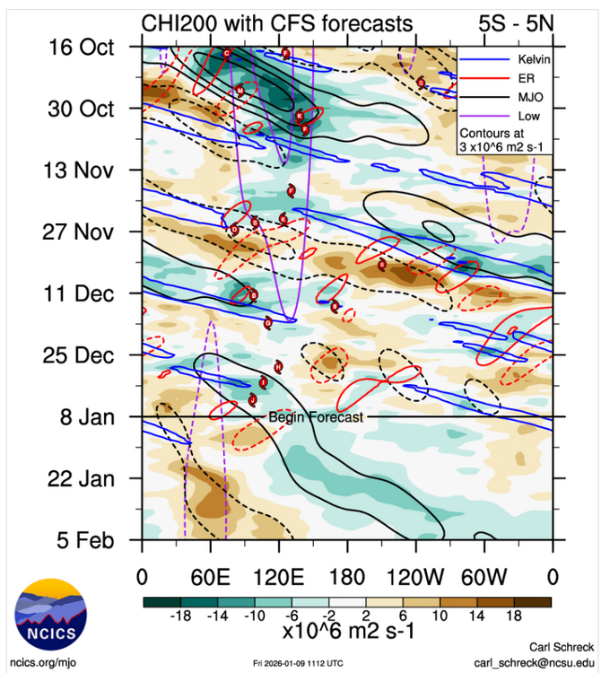
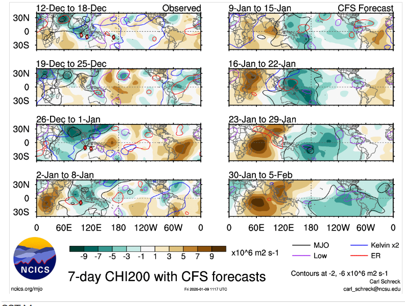
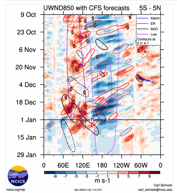
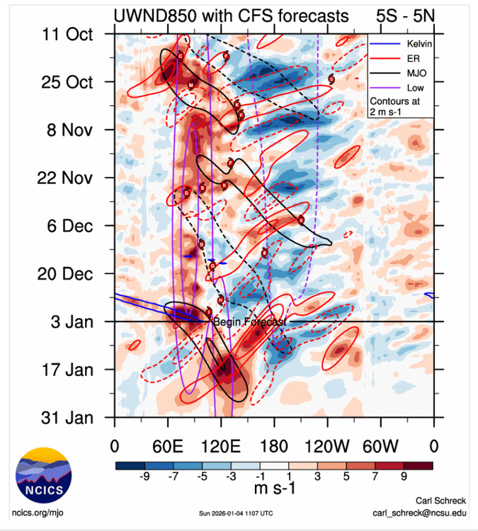
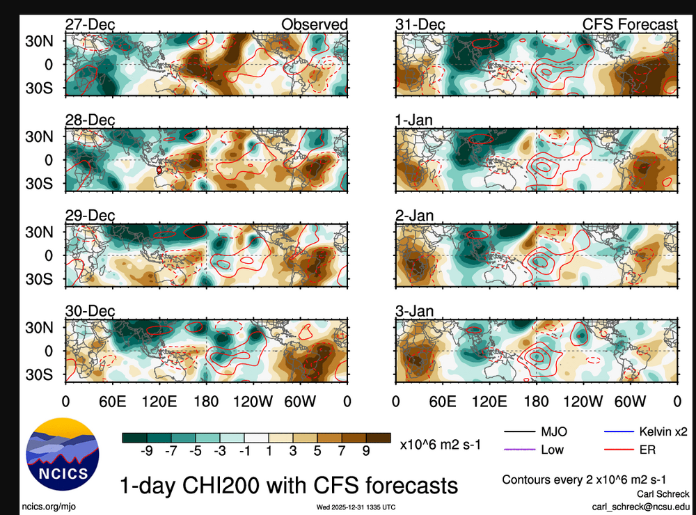
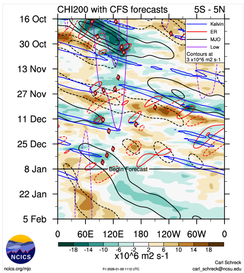
Seemingly we are starting to see a pattern change upcoming,the tropical forcing is getting taken out of the WP/MC which is what we've been seeing literally since fall I'm using the GEFS and CFS I.E,take out the tropcial forcing you dont see these troughs going trough East Asia,
-
Sorry to hear this about your mom also,prayers for you and your fam
-
I wouldnt trust any model this far out,seen it to many times in our parts when systems get buried here towards the GOM,theres alot that can go wrong.I.E for us in Mid Tn convection down south can cut off the QPFS,there us also other factors as well,positive tilted troughs can possibly kick the moisture out much faster,could go on and on but CMC looks to be the big outlier right now
-
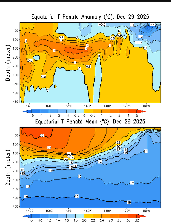
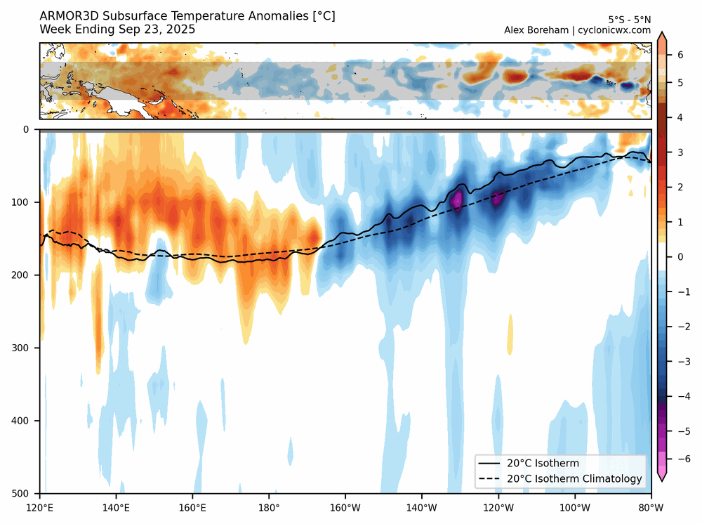
I mean each day you see the subsurface warming east of the IDL and slowly moving upwards towards the surface,its still NINA,buit you are seeing its demise every day mow
-
Kinda question a modoki later ,in 2023 many people said the same thing but it never happened,we are actually headed towards the same scenerio but with even more questions if this will might even happen,its still why i like the 2022-2023 analogs winter,the top was around the same time in 2023,the bottom is 2026 latest
-
Maybe something to watch the next couple days,not all the models still agree with the timing, On this afternoons run the GFS shows the columns basically saturated in the TV,even tho there is some half decent SRH,looks more like some potential hefty rain ATM with the LLJ kicking up to 50 to possibly 70 kts Day 4-8 Convective Outlook NWS Storm Prediction Center Norman OK 0331 AM CST Sun Jan 04 2026 Valid 071200Z - 121200Z ...DISCUSSION... A low-latitude closed low west of Baja CA at 12Z Wednesday should evolve back into an open wave, aided by the development of a large-scale trough becoming established over the West. EC-AIFS and AIGFS remain the preferred guidance for a more probable slower ejection of the low-latitude wave onto the southern Great Plains through Thursday. At least isolated severe potential seems plausible to the east-southeast of a southern High Plains lee cyclone as a modifying warm-moist sector advects north from the western Gulf. But yesterday's NCAR ECENS-based ML guidance remains below 5 percent for Thursday, while the latest GEFS-based SPC-CSU and NSSL ML guidance have trended lower to only 5 percent peak areas. D6/Friday still appears to have the best relative severe potential, despite the pair of GEFS-based ML guidance trending lower and in areal extent of 5 percent peak probs. Neither of these have any appreciable overlap with the preferred ECENS-based 5 percent areas from NCAR. In any case, an amplified upper trough appears likely to shift from around the Rockies to the Great Plains. Most EC-AIFS ENS members now support central states cyclogenesis. But predictability remains low regarding the spatiotemporal details and amplitude of cyclogenesis, which is likely related to the handling of shortwave impulses embedded within the broader trough. An area-of-interest for a future 15 percent severe highlight roughly includes the Lower MS to TN Valleys and Deep South.
-
Ive been thinking something similar to 2022-2023i,mayve more or less the wave lenghts dont match up,but it was a cold Dec Christmas 2022,and much AN into J/F,i dont see that being a bad analog year,least right now unless something changes
-
Still a NINA anyways,tho since Dec the subsurface has been pushing further east since early Dec east of the IDL
-
In Mid Tn some of most catastrophic ice storms happen during a more or less in a moderate NINO.I.E 1951 and 1994,we in general in Tn have have two distinct weather patterns east and west of the Cumberland Plateau.In a NINA a ice storm is more common east of the Cumberland,during a NINO its west. We get some of our best winter storms in a NINO than compared to a NINA around Nashville.Though in general it starts out with ZR and/or IP before the columns cool to become all SN Edit:I'm not trying to dispute you if what i said,just adding to climo here,what you said is in general is right around BNA,cold surface temps and WAA is a recipe for ice
-
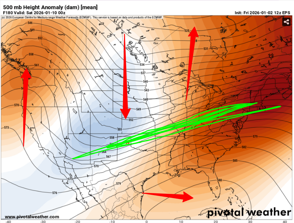
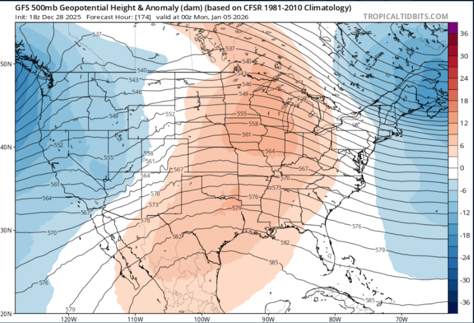
Typical +TNH,while we get into wk2 of Jan,+PNA,Trough AXIS in the middle of the country,subtropical ridge builds over Florida and the JET is well north of the Tn Valley,i actually thought we'd have a chance last week to maybe have somewhat a better pattern,but even tho it looks good in East Asia,other teleconnections still play a part in NA,so this time seemingly might not work out well for us
-
This is true.Just to clarify myself.I'm not saying this is gloom and doom,i should have worded my words better. But its really been a unusual pattern so far.You see this standing wave along the MC,WP since fall and the interaction with Rossby and Kelvin waves the past few weeks is killing the MJO signal and more than likely will continue. When you have a +TNH which is what social media is the talk about,this causes the trough axis to shift west,then you see the subtropical ridge over Florida.But,this looks more transient on todays ensembles on the long range. I honestly wouldnt trust any of the LR models right now.
-
I plead the 5th
-
The GAAM albeit was still in the COD,it was still positive
-
I mean, when i see the MJO and the GAAM in spring coupled with each other id be getting excited with severe weather if the MJO was into phase one or two,its just not coupled right now,but this winter we have gotten our cold when the AAM is positive not negative,what you are seeing now

-
I just dont think BAM is right. This winter we see the tropical forcing is more or less has been into the WP/MC,its kinda opposite of what he says. You can actually look when East Tn got its early season snow was when the GAAM was positive and not negative.The GAAM should still sync up with the MJO to couple with it.
-
But BAM is missing with the tropical forcing,sorry but hes wrong
-
Edited that about to fall not autumn
-
Yeah but the tropical forcing since fall has been more or less into the MC/WP with Rossby and Kelvin waves none the less a standing wave just as well.Its one reason why you see East Asia keep troughs in East Asia continous
.thumb.gif.75b0e5d9e7d5907daf8dc69c92dac58d.gif)
-
Better get something fast,it looks rather bleak right now down the road with that strong ERW thats fixing to pass along the IDL the next few days,Maybe it will weaken some but this could cause the tropical forcing to shit towards the WP into the MC,probably end up seeing RMM madness continue,you're seemingly starting to see the NINA background getting taken out now even tho it's still NINA.
-
To an extent this is true,but besides a NAO the first step is a good PNA in our parts , really some deception to East Tn to the West.TN,mountains im sure causes part of this,while the east wants to see a more stronger -NAO,it dont work like that from the close to the Cumberland to West it just leads with us with cold dry with cutters,compared to the east,we really live in a weird climo in Tn in winter,its really unusual to see the state wide snowfall at the sane time
-
I dunno,its just what i see now but planetary waves can disrupt the pattern,its nothing like equatorial waves
-
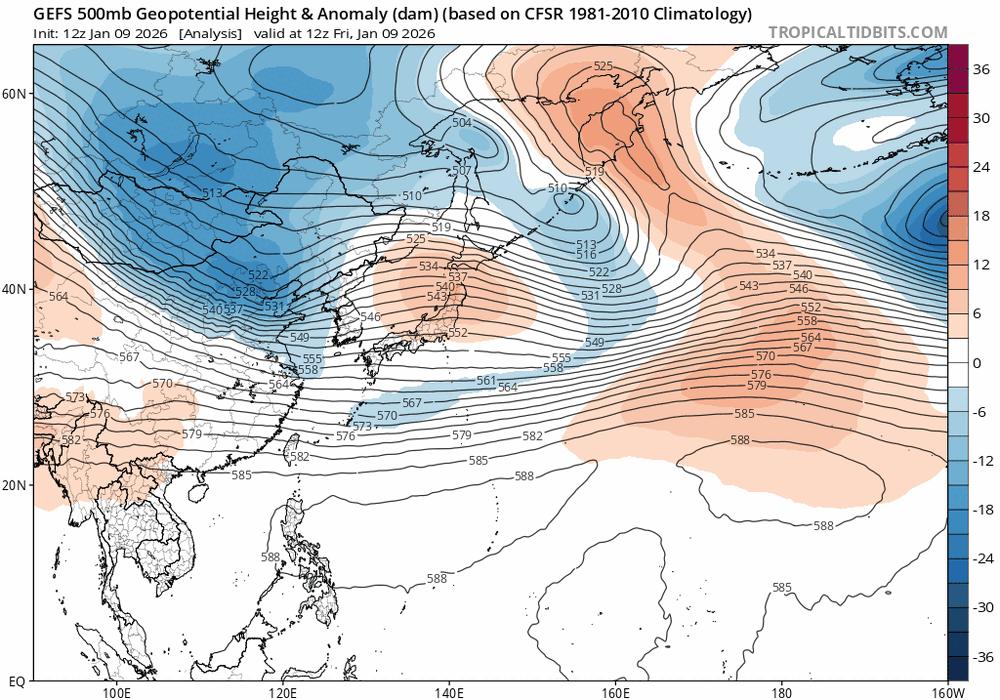
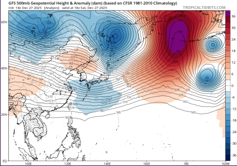
Yes,they didnt put there link at the bottom for nothing more than click bait,But in general you can look at East Asia to show you what the pattern might look like in several days,you see a trough going through Mongolia/Russia,with ridging building up into the Koreas with a ULL passing by NE Japan,it should look like this a ridge in the middle of the counrty,a crappie PNA and a ULL IN the NE,still the same the cold in winter relies on other teleconnections
-
Its happened before with the AR out west during a NINA,buts its still more common with a NINO not NINA,it happened before in the winter of 2022-23


.gif.10cb59edf92dc94e2c32f5ea854901bf.gif)
