jaxjagman
-
Posts
9,046 -
Joined
-
Last visited
Content Type
Profiles
Blogs
Forums
American Weather
Media Demo
Store
Gallery
Everything posted by jaxjagman
-

December 2025 Short/Medium Range Forecast Thread
jaxjagman replied to John1122's topic in Tennessee Valley
GEFS looks more Euro now with any SSW,you can see it here -
December 2025 Short/Medium Range Forecast Thread
jaxjagman replied to John1122's topic in Tennessee Valley
Id agree with what Jeff said up above .We seem to be seeing the the SSW underway with the sharp rise in temps into the stratosphere but even so ,the cold seems to be getting pushed back seemingly each day.The JMA right now shows a strong MJO signal in the WP into the first of Dec,while this isnt bad it still should have reflection to more or less a SER,just transient cold shots.Might not be a bad thing if you want a cold Christmas or even possibly beyond that for a couple weeks anyways.png.8ab108ae7e0dd138d17f3b7be0b7e030.png)
-
December 2025 Short/Medium Range Forecast Thread
jaxjagman replied to John1122's topic in Tennessee Valley
Cool,he finally got this running again.thumb.png.8754ab3f849d107be4ed22622bf61488.png)
-
December 2025 Short/Medium Range Forecast Thread
jaxjagman replied to John1122's topic in Tennessee Valley
LOL Looks like the quite a few members jumped the train today...lol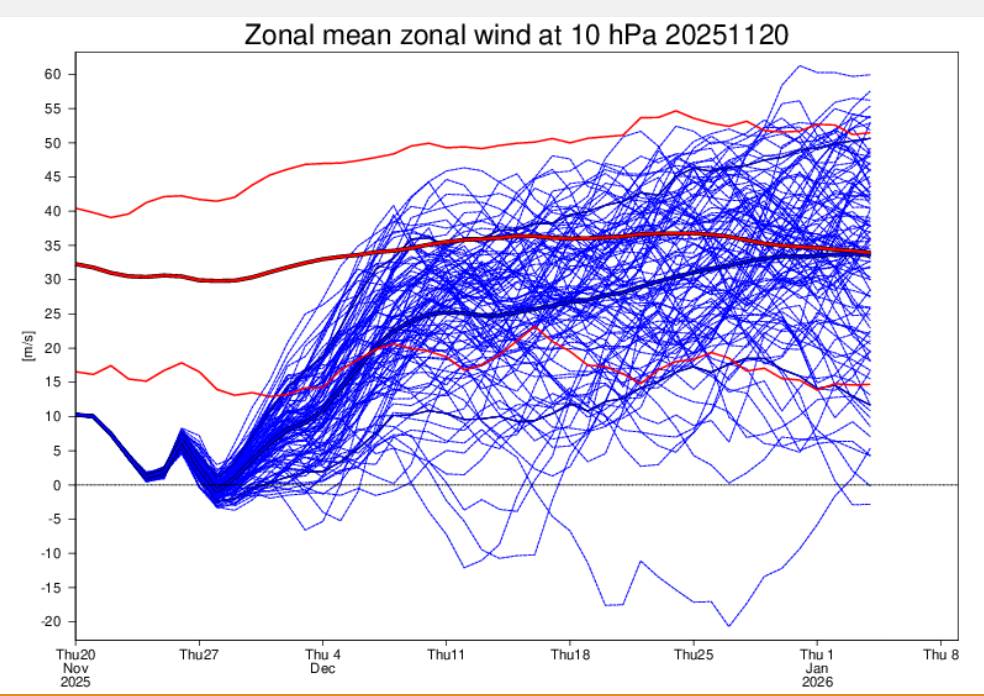
-
December 2025 Short/Medium Range Forecast Thread
jaxjagman replied to John1122's topic in Tennessee Valley
Thinking the same thing @ Carver.Like Jeff metioned a week or two ago,its gonna take a couple CF's to beat down the SER,before it can get really cold,otherwise its just gonna be transient cool down i agree also the Euro suites struggle with systems out west,more than likely today with that trough out west.GEFS dont show much change today,not perfect but not as extreme as the EPS -
December 2025 Short/Medium Range Forecast Thread
jaxjagman replied to John1122's topic in Tennessee Valley
See what it shows this afternoon,shouild update in about a hr and a half -
December 2025 Short/Medium Range Forecast Thread
jaxjagman replied to John1122's topic in Tennessee Valley
EPS seems to be having a rough time to have such volatile swings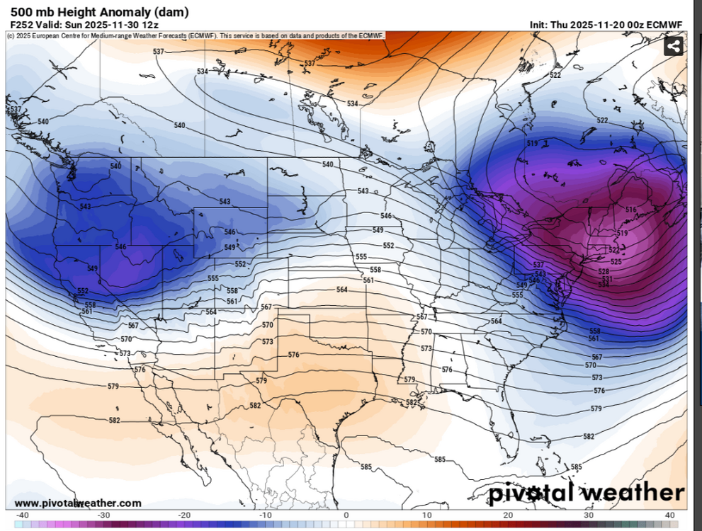
-
December 2025 Short/Medium Range Forecast Thread
jaxjagman replied to John1122's topic in Tennessee Valley
The map he showed was the OZ,i assume early this morning,mine was yesterday afternoon,so it must have changed between -
December 2025 Short/Medium Range Forecast Thread
jaxjagman replied to John1122's topic in Tennessee Valley
I seen that this morning,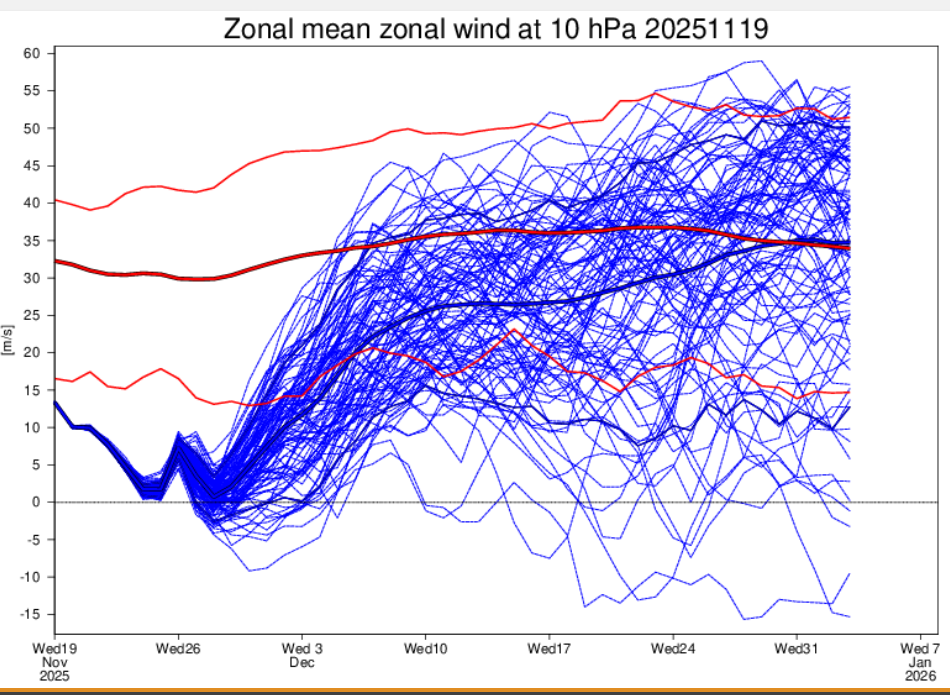
-
December 2025 Short/Medium Range Forecast Thread
jaxjagman replied to John1122's topic in Tennessee Valley
Euro backed off from any SSW upcoming with not much of any wind reversal to what its been showing.JMA has the temps around -65C which is around what the Euro shows last update,Euro only shows the temps will get close to -60C in 10 days,so right now no SSW just some weakening,least not right now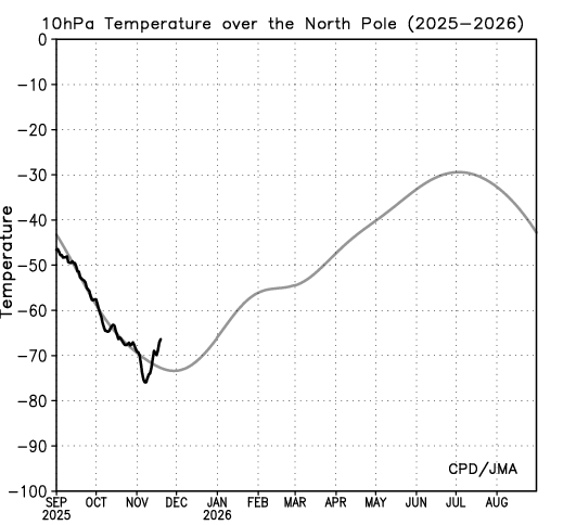
-
December 2025 Short/Medium Range Forecast Thread
jaxjagman replied to John1122's topic in Tennessee Valley
BOM has the reconstructed MJO back to 1975 here,i know you look at analogs all the time maybe that can help out some https://www.bom.gov.au/climate/mjo/#tabs=Monitoring -
December 2025 Short/Medium Range Forecast Thread
jaxjagman replied to John1122's topic in Tennessee Valley
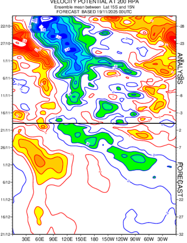
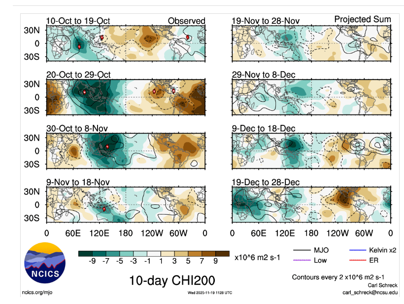
I got cut off for a few min,kinda busy ATM,but by those pics seemingly shows into the 2nd week of Dec into the WP just constructive interference from Rossbly.Kelvin which looks like the MJO is into the Maritime/WP,but its not.Its still in the WH and getting into the IO towards the end of the month of Dec, -
December 2025 Short/Medium Range Forecast Thread
jaxjagman replied to John1122's topic in Tennessee Valley
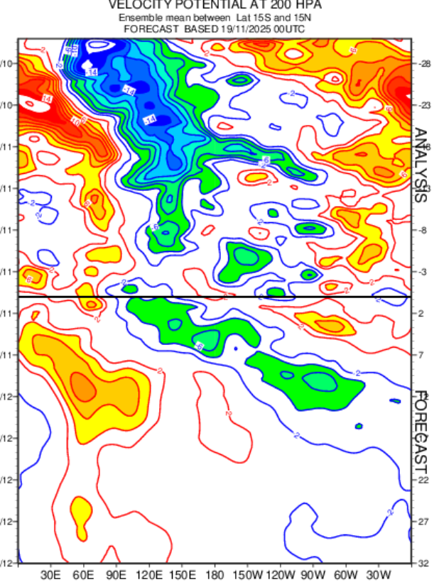
Just to edit the pic above ill post it here,wasnt aware i cut the dates out
-
December 2025 Short/Medium Range Forecast Thread
jaxjagman replied to John1122's topic in Tennessee Valley
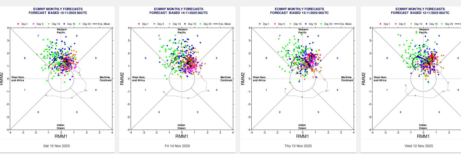
Typically Dec in Mid/Tn is the wettest month of the year,its even wetter in West Tn into the Ozarks. Take these maps with a grain of this far out,probably from Rossby,Kelvin Waves,,but at least the Euro is showing something similar,but once again a grain of salt this far out
-
Fall/Winter 2025-26 WX Discussion Thread
jaxjagman replied to Carvers Gap's topic in Tennessee Valley
Our landscapers came and did our lawn yesterday,you couldnt tell today,we had just some wind gust probably just around 15-20mph,but it was raining leaves,shitty foilage year here -
Fall/Winter 2025-26 WX Discussion Thread
jaxjagman replied to Carvers Gap's topic in Tennessee Valley
Euro ensembles seems to being getting more support each day it will finally get out of P6,while the MEAN is faster and little support but P7 isnt horrible Edit:You just need to be patient until then,its not even Met Winter yet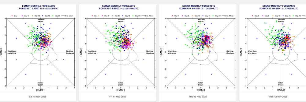
-
Fall/Winter 2025-26 WX Discussion Thread
jaxjagman replied to Carvers Gap's topic in Tennessee Valley
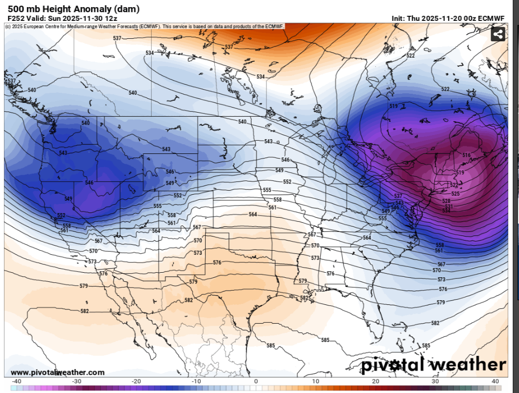
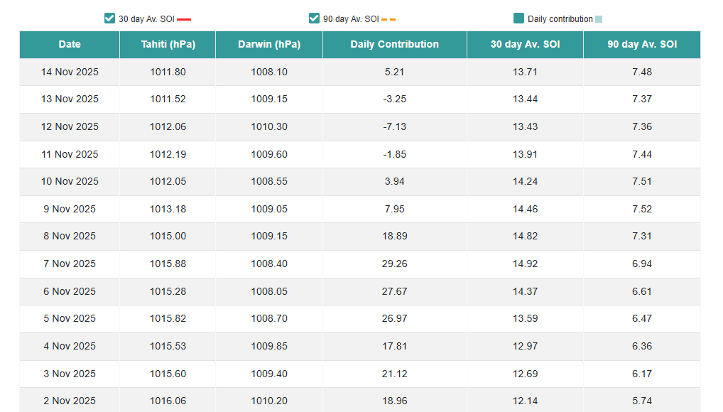
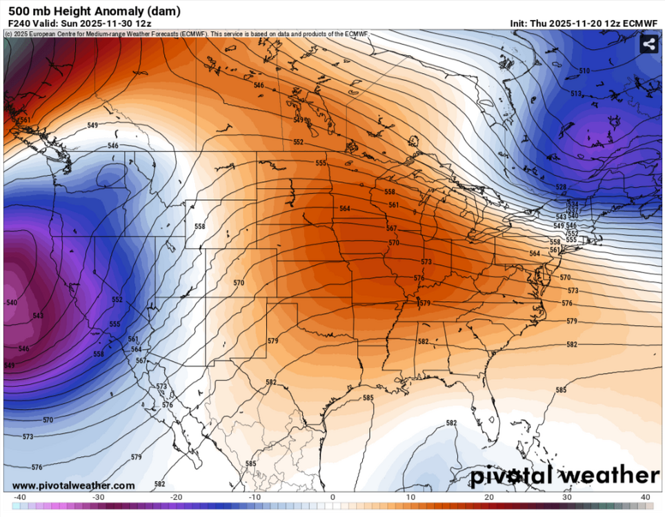
The SOI took a big rise recently.Seems like we'd be seeing some sort of strong CF, maybe the end of the month,Nov first of Dec along with the MJO possibly getting out of the unfavorable WP and possibly WH,tho the Euro Mean dont have alot of support.The SSWE today the Euro backed off of any SSWE.But the Euro does have some support it should turn colder into the first week of Dec with the ensembles.Just need the MJO to stay active,hate a warm Christmas,you always as we get into winter in out parts want to see troughs into East China into the Sea of Japan,thats a cold look as long as the NAO cooperates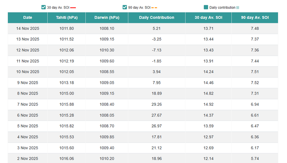

-
Fall/Winter 2025-26 WX Discussion Thread
jaxjagman replied to Carvers Gap's topic in Tennessee Valley
Should have said we'll know more by next week.But some of social media especially on X make it sound like the apocalypse is coming.We're gonna fall -800C below normal,snow drifts as tall as the empire state building,we're all gonna die.Like there hasnt been a SSWE before. -
Fall/Winter 2025-26 WX Discussion Thread
jaxjagman replied to Carvers Gap's topic in Tennessee Valley
You have to have warming with the wind reversal to be a major SSWE,right now it just seems to be a minor,but thats to early to tell,Euro only shows the wind reversal lasting just a couple days.We'll find out soon enough,next week. -
Fall/Winter 2025-26 WX Discussion Thread
jaxjagman replied to Carvers Gap's topic in Tennessee Valley
Where is this,cool pic anyways?Looks so surreal,awesome -
Fall/Winter 2025-26 WX Discussion Thread
jaxjagman replied to Carvers Gap's topic in Tennessee Valley
Prior the turkey day it looks to be a battle between AI/GFS/Euro VS the ensembles In a real mans world you'd stick with the ensembles this far out.Guess we'll see who caves in the upcoming days.But i thought my self there would be a trough in the East before turkey day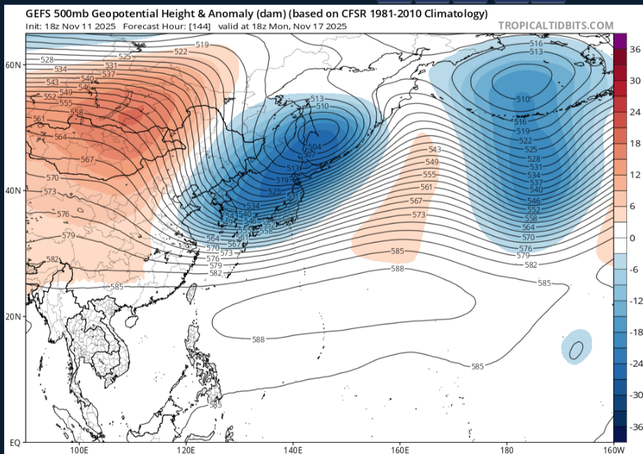
-
Fall/Winter 2025-26 WX Discussion Thread
jaxjagman replied to Carvers Gap's topic in Tennessee Valley
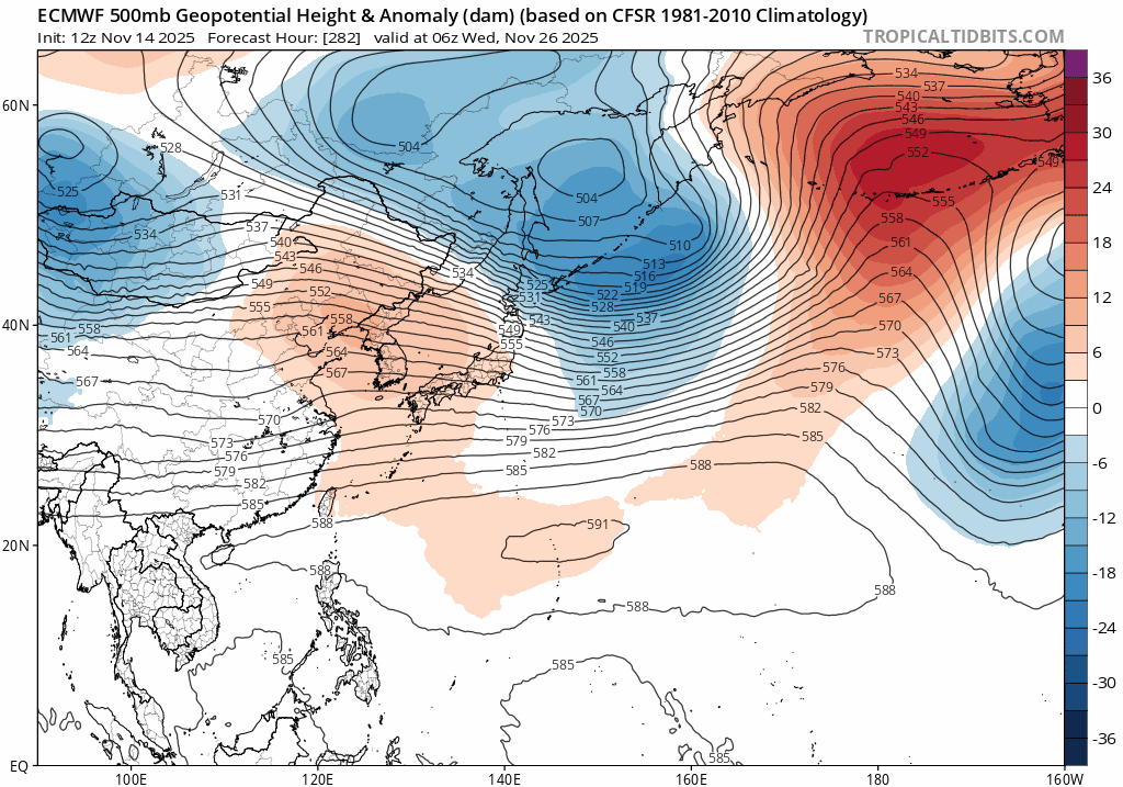
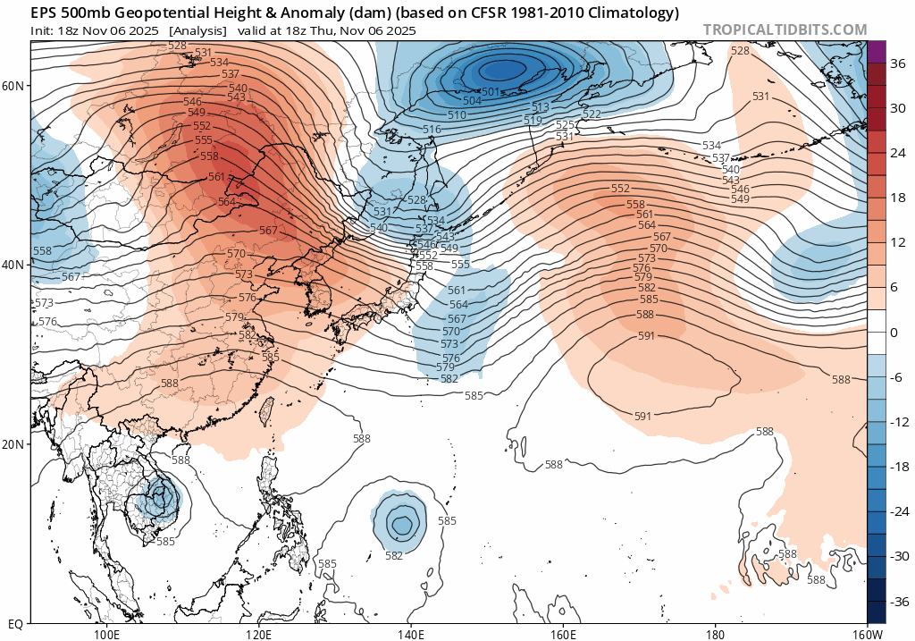
My thinking is later on there will be a phoon headed towards China the next couple days,this will pump up the heights from the Yellow Sea into Japan along with the MJO headed into the WP,so that should be height rises towards Mid Nove for a few days,guess the good news right now is the MJO could possibly go into the COD,but anyways what the EPS seems to be showing today is a trough going thru East Asia round the 15th,so we'd probably be seeing a CF right before thanksgiving and back to BN temps at least for a bit..JMO
-
Thought it would be a more severe thunderstorm not tor watch
-
URGENT - IMMEDIATE BROADCAST REQUESTED Tornado Watch Number 635 NWS Storm Prediction Center Norman OK 325 PM CST Fri Nov 7 2025 The NWS Storm Prediction Center has issued a * Tornado Watch for portions of Northern Alabama South-Central Kentucky Middle into Eastern Tennessee * Effective this Friday afternoon and evening from 325 PM until 1000 PM CST. * Primary threats include... A couple tornadoes possible Scattered damaging wind gusts to 70 mph possible Isolated large hail events to 1.5 inches in diameter possible SUMMARY...Scattered thunderstorms are forecast to develop and intensify through the remainder of the afternoon and persist through much of the evening, as they move west to east across the Watch area. A few of the stronger storms will likely become supercellular and pose a risk for isolated large hail and perhaps a couple of tornadoes. Scattered damaging gusts (60-70 mph) are possible with the stronger storms and may focus with the more organized thunderstorm bands as a mix of linear and cellular storms evolve. The tornado watch area is approximately along and 85 statute miles east and west of a line from 60 miles north northwest of Crossville TN to 40 miles east of Muscle Shoals AL. For a complete depiction of the watch see the associated watch outline update (WOUS64 KWNS WOU5).
-
Looks meh,DP's arent even into the 60s along the Al/TN line,no convection other than 1-40N ATM

.png.363184d55bca212eb42bb968f3f78e60.png)