michsnowfreak
-
Posts
18,449 -
Joined
-
Last visited
Content Type
Profiles
Blogs
Forums
American Weather
Media Demo
Store
Gallery
Everything posted by michsnowfreak
-
The key phrase all must remember in the coming days lol.
-
There is consensus of a storm. That's about the only consensus you will have for at least 5 days.
-
To each their own. For me, It's not about remembering as much as it is enjoying Winter. It's the beavis in me. Were the clippers memorable? Of course not. But it's a Winter wonderland outside. Just like when they have shit Winters on the East Coast with nothing but bare ground, if I lived there, I don't think it would be any consolation to just remember past storms. In terms of remembering, nothing like the winter of 13-14. I can't imagine any single storm could surpass that. I remember the blizzard of 99 well and of course ghdII is my favorite, but immediate thoughts always go to 13-14. Every year this time when they bring up the blizzard of 78, I always have to really wonder. It's become such lore and there's always pomp and circumstances surrounding it, that I wonder what it would have ACTUALLY been like to experience it in Detroit. It's well documented that snowfall totals were far less on the East Side of the state. I'm sure it was a good storm with winds, blowing snow, falling temperatures, etc, but widespread reports of only 8 to 10" in this area certainly lump it in with many other storms. And had that same thing happened today, I have a feeling the storm would be remembered for being a massive close miss. I cannot fathom a weenie Fondly recalling a storm that dumped 9" of snow here and 3' a few counties West.
-

Winter 2021-22 Short/Medium Range Discussion
michsnowfreak replied to Chicago Storm's topic in Lakes/Ohio Valley
Oh ok that makes sense. Snow depths right now around 30" in Munising, we will both be in that area later in the Winter. Outside of the lake superior shore, snow depths in the UP seem a bit underwhelming compared to what they should be. -
Winter 2021-22 Short/Medium Range Discussion
michsnowfreak replied to Chicago Storm's topic in Lakes/Ohio Valley
Nantucket seems a better bet. -
I talk to Andrew from Long Island all the time and he would rather have our climate with frequent snows and flakes...they just don't get that. He has seen some incredible storms but they are in and out in a flash. Obviously it's a little different in NE, but still. An east coast climate is big risk, big reward, big disappointment. These models tho. Yikes.
-
Should be quite the comedy show watching the struggling models figure this one out over the coming week.
-
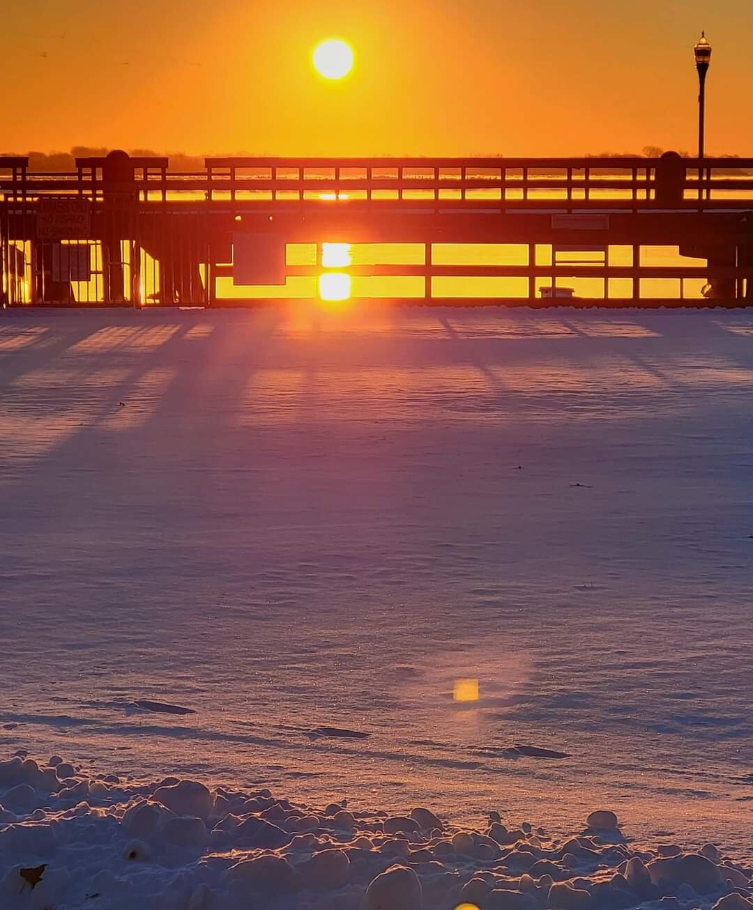
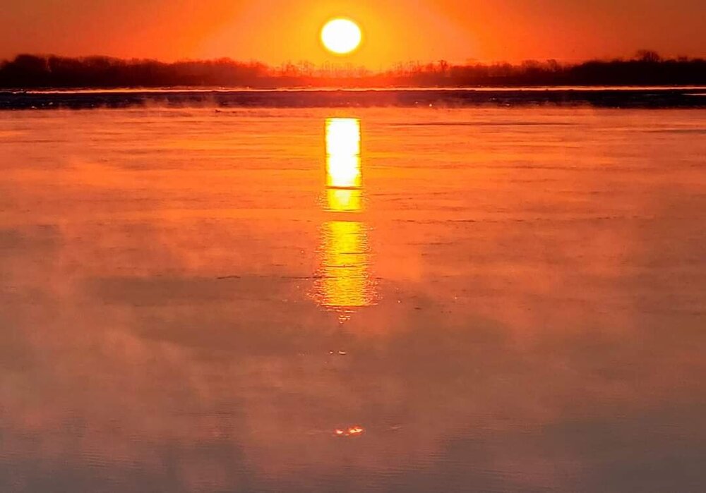
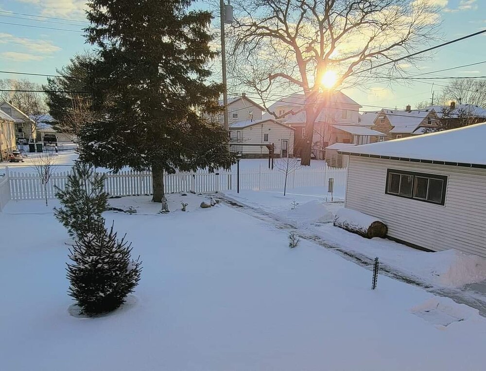
Woke up a little earlier than normal and couldn't fall back asleep so bundled up and went down to the Detroit river to watch the sunrise. It was absolutely gorgeous, the air temp was about 4゚ so there was steam coming over the open water (no matter how cold it is the river won't freeze solid due to ice cutters and current). As the sun rose the snow sparkled and took on different hues of orange. I really do take for granted that this scene is literally a few blocks from my house every clear morning.

- 405 replies
-
- 18
-

-
9"+ snowstorms are not as common as you would think, I think the midwest is a 1 to 6" climate in general with the occasional bigger storm. Contrary to that 1 poster's incorrect assumption, Detroit having 4 snowstorms of 9" and the last 5 years is actually very good and more than most cities in the region. It would take a bit of research but I wouldn't imagine only a handful of 9"+ storms are seen per decade at any one local. Detroit has had 11 in the past 15 years but that includes some stellar Winters. If you lower the bar to 8"+ you're adding quite a few more to the pile.
-
Winter 2021-22 Short/Medium Range Discussion
michsnowfreak replied to Chicago Storm's topic in Lakes/Ohio Valley
While it's always common for the op guidance to shift wildly from run to run, I have noticed lately how how ridiculously different the ensemble means are from run to run in the extended. -
Thanks for those charts. The mid 20th century was terrible for snowfall in this area. If 1930s through 1950s Winter's happened today, I shudder at the thought of every single event being attributed to global warming. There were a few good ice storms and of course the occasional good bout of snow, but as a whole that was one depressing 30 years stretch for snow lovers.
-
Actually you're obsessed with saying I polish turds even if I don't say a word. You just seem to not believe the fact that some people can like winter the season without obsessing over rates or a storm total amount. And actually, dtw had a bigger storm last winter than ord. It's amazing that people that simply discuss the weather or post stats are turd polishing or bullying, but you just spout off baseless junk with nothing to back it up, apparently no knowledge of how weather/climate works.
-
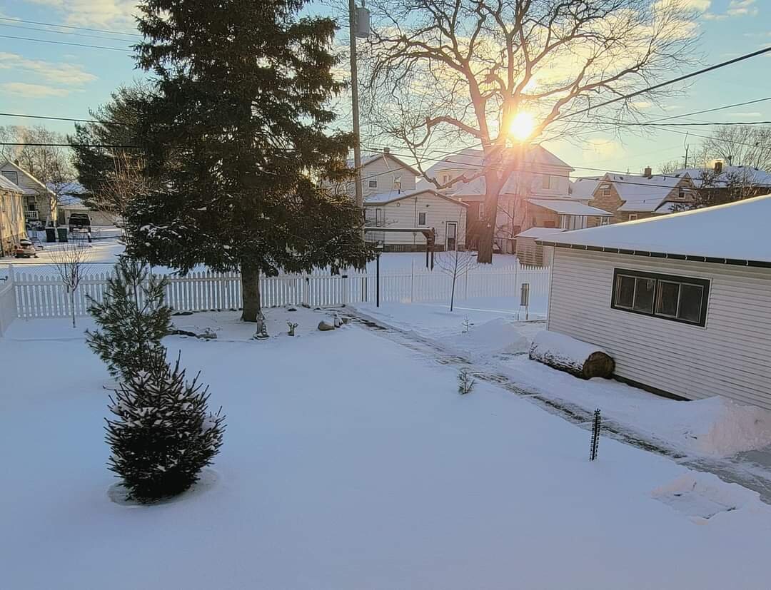
Glistening winter morning. Deep cold and fresh powder....perfect for the dead of winter.
-
17 storms the last 5 years have dropped 4+ at DTW, including 4 over 9". Yup. No organized systems in 5 years. Also, snow depths last Feb reached 21" in Chicago, 18" in Toledo, and 14" in Detroit. Impressive with no organized systems. Nov. 27/28, 2021: 4.3" Feb 15/16, 2021: 10.4" Feb 4, 2021: 4.1" Jan 18, 2020: 6.8" Feb 25/26, 2020: 5.5" Nov 11/12, 2019: 9.2" Jan 19, 2019: 5.8" Mar 1, 2018: 5.0" Feb 9, 2018: 9.2" Feb 6/7, 2018: 4.2" Feb 4/5, 2018: 5.3" Dec 24/25, 2017: 5.4" Dec 13/14, 2017: 6.5" Dec 11/12, 2017: 4.0" Mar 13, 2017: 5.3" Jan 30/31, 2017: 4.6" Dec 11/12, 2017: 10.7"
-
Clipper #3 dropped 2.6" powder here. I was hoping for more, but clipper #2s 3.1" was more than double what was expected, so it's all good. Love seeing the mounds of powder everywhere. And definitely have fallen in love with my snowblower, piles be damned.
-
Some weaken. Some don't. Always been that way. Can definitely name multiple events the last 4 years that didn't weaken lol.
-
It certainly does. Snow falling on fresh snow. Love it!
-
Winter 2021-22 Short/Medium Range Discussion
michsnowfreak replied to Chicago Storm's topic in Lakes/Ohio Valley
Speak for yourself lol. Feb is not 100% done. I live in Michigan. And Feb doesn't even start for 8 days. -
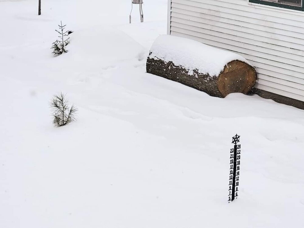
Today's 3.1" snowfall had 0.20" liquid. Pure powder. Forecast tomorrow is 2-4".
-
Finished with 3.1" of powder. Definitely overperformed here and it's my favorite type of snow. Bring on tomorrow. Detroit finished with 3.0". North of Detroit saw 1 to 2" with 3 to 4" near the Ohio border. Clipper#1- 0.2" (expected T) Clipper#2- 3.1" (expected 1-2") Clipper#3- tbd
-
Snowing very nicely out and stacking up well. This clipper will easily be an overperformer here. Should easily hit/exceed 3"
-
Got 0.2" today, I guess from remnants of clipper 1 which I didn't expect. Bring on the next 2! Looks like toledos snow hole ends.
-
Oh I love to head into the woods and hike. I want to snowmobile too.
-
Looking good for some dry clipper snow. Id say Detroit looks good for 1-2" tmrw and 1-3" Monday. Chicago looks 2-3" tmrw and 1-2" Monday.
-
I booked a cabin on Vrbo in Au Train, not far at all from Munising, Feb 21-25. We all have the same idea lol. Best, deepest snow is always late Winter.