michsnowfreak
-
Posts
18,382 -
Joined
-
Last visited
Content Type
Profiles
Blogs
Forums
American Weather
Media Demo
Store
Gallery
Everything posted by michsnowfreak
-
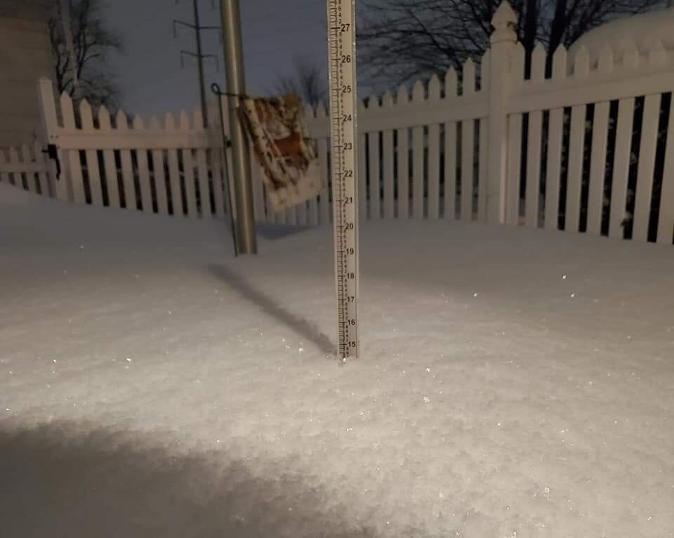
Actually the storm was a good hit for the east side. There was wave 1 which dropped 1-2" in the morning...then the main event evening into the next morning which dropped 6-10" on the east side. DTX did NOT count the morning wave in their storm summary. So the two day totals were widespread double digits on the east side depends how you counted it (some nws offices counted 1 storm, some 2). The Feb 4th storm was the insane band where the 4-hour 4" snowfall saw the first 3" fall in like 75 minutes. Those were the best synoptic rates I've seen in years. https://www.weather.gov/dtx/210215winterstorm
-
I would be shocked if there weren't some power house storms in the area in a 2nd year Nina. Based on track you risk anything from snow to ice to rain or a mix of all 3...but chances should be there. Btw...don't forget about Feb 15/16 storm last year. 11" fell, good rates and drifting in the evening. It was definitely the most severe storm we have had in a few years (although Nov 11 2019 was the most anomalous).
-
Lol. For real though, since 2010, which is 12 years, Detroit has averaged 18.3" of snow in Feb. This is literally double the longterm average of around 9". Going back a full 20 years we have averaged 16".
-
The amount of snow we have been getting in February is insane. It's unlike anything I've ever seen in the climate record in terms of varying so dramatically from the average on such a consistent basis.
-
Last Winter lake Erie actually peaked at 81% ice coverage which is above average peak. But this was entirely Feb. Seems like even Erie only fully freezes in cold winters.
-
Id have to look into it more. Maybe it affects areas in the snow belts more, since they have the highest averages.
-
The thing is Michigan is a cold state so Temp departures and snow don't go hand in hand as they would in, say, the mid Atlantic. Northern Michigan can have a banner snow year with way above avg Temps. Likewise a bitter cold winter can freeze the lakes early and shut off the lake effect machine prematurely leaving to well below normal snow. I've studied a ton of climatology for Detroit and even in the "warmest" and" least snowy" part of the state, there is no direct correlation with temperatures and snowfall. Once you get to the North country, it's an absolute crap shoot. And what I mean by correlation, is that everything is basically dependent on weather patterns and storm tracks.
-
Where are you seeing this?
-
Always concerns in late Fall. Just hope the cold produces.
-
Snow squalls last night. 0.1 of snow fell. Got this neat picture closeup of snow dusting a fallen leaf
-

Could it be? November 13-15 Potential Snow
michsnowfreak replied to Hoosier's topic in Lakes/Ohio Valley
Snow fell steadily most of the day today. It it mostly melted as fell, just slushing up a bit. I recorded 0.20" of precip, all snow, but only a total snowfall of 0.2". It was nice to see and just a reminder that the long Winter awaits. Just to my west there was more accumulation with 0.7" at DTW and 1 to 2" near Ann Arbor. -
Could it be? November 13-15 Potential Snow
michsnowfreak replied to Hoosier's topic in Lakes/Ohio Valley
Bring on snow!!! I am ready! -
A thick frost with DTW getting to 27 this morning
-
After DTW saw the first snowflakes Nov 2nd, the first freeze (29°) was Nov 3. It was a brilliant crisp morning and the finale of what was a dull color show is beautiful!
-
Saw the 1st flakes here as well. My mom called me to say "Hey it snowing out" and sure enough it was. Scattered flakes throughout the day, nothing of consequence but just nice to see those 1st ones
-
sun setting yesterday
- 218 replies
-
- 10
-

-
First frost this morning. Low at DTW 36 but rural places had a freeze.
-
only a few clunkers in there. nice.
-
thanks. interesting to look at. but of course just that lol. I cannot remember where I saw it, but there is a graph somewhere that will tell you what your city's average snow liquid ratio is.. I think for Detroit it is 12 to 1, which would put this 33 closer to 40" (current avg is 44"). I'm assuming new England is similar? fluffier in nne and wetter at the coast.
-
I have weatherbell but they don't have that neat graphic. Could you please show DTW?
-
It was a warmer than average September at Detroit, tied for the 25th warmest on record, but no record highs were set, only a record cold Max of 53 on September 23.
-
I just looked up the Jan avg, not avg for Jan 1st, but 1961-90 January is 2.5° warmer than 1991-20. Still significant but nowhere near 6°. It does appear that 1961-90 was the aberration though. As we all know station station sites change, both location and surrounding environment, but it's pretty typical to have 1961-90 by far the coldest normal set for any station in the Midwest. Chicago's official January temperatures are currently 2.5° COLDER than they were when your grandparents were walking uphill barefoot in 6 feet of snow. Chicago January avg/high low: 1901-30: 32/18 1931-60: 33/20 1961-90: 29/14 1991-20: 31/17
-
Sneak in 1881 there tied for 7th place. The only reason I know that is because I had to look it up, not seeing it on your list. That's the warmest September on record at Detroit. (2021 did not make the top 20).
-
More color appearing by the day. Will be interesting to see if the warm weather slows it.
-
I have nothing to back this up other than my knowledge of climate, but I have a feeling it is going to be a stormy Winter locally. La Nina is historically a conga line of storms into this region. Last Winter I was envisioning a ton of precipitation, both rain and snow, but yet each Winter month ended up drier than normal. Even February with it's heavy snowfall & deep snow pack saw liquid precipitation slightly below average (owing to both the fact that most of the snow was powdery and also the fact that there was no rain). In the end season snowfall was right around average to slightly above in spots, yet it was a drier than average Winter (which contradicted literally every model forecast). Overall there has been a slight increase in precipitation the past few decades, I don't know if we've ever had 2 dry La Nina's in a around, and a wetter pattern has taken hold starting the 2nd half of summer.