

michsnowfreak
-
Posts
17,982 -
Joined
-
Last visited
Content Type
Profiles
Blogs
Forums
American Weather
Media Demo
Store
Gallery
Everything posted by michsnowfreak
-
Had to since the temps were far from ablazing this summer!
-

Summer 2023 Medium/Long Range Discussion
michsnowfreak replied to Chicago Storm's topic in Lakes/Ohio Valley
It was fun this summer watching the heat just hit a wall most of the time before making its way to the eastern Lakes. Crazy to see the disparity between Chicago and here. # of 90F days in 2023 Milwaukee- 10 (max 101) Chicago- 21 (max 100) Minneapolis- 32 (max 98) Detroit- 2 (max 90) Flint- 2 (max 91) Cleveland- 2 (max 91) -
September 2023 General Discussion
michsnowfreak replied to hardypalmguy's topic in Lakes/Ohio Valley
After a pleasant summer and fairly dry September so far, the colors are poppin. Hoping the upcoming warmth isnt too much of a hinderance. -
I didnt know you cared for cherry picked data so much. Ill post a TON of fun snow stuff for you with winter coming. Speaking of relevant to our area, it was so nice to have such a pleasant summer here while the sweltering occurred to our south. Lowest annual max temp in 108 years. So refreshing. Great Lakes ftw.
-
I am not afraid to backup facts to people like climatechanger. He wants to pull out the "you dont believe in climate change" card, then thats ignorant. Huge difference between believing in climate change versus following a hard-nosed agenda.
-
LMAO @TheClimateChanger. Funny, I just picked apples last week. A September tradition. I guess youre still picking cherries. First of all, Id LOVE to see a link to this alleged post 10-15 years ago I was having none of. For starters, I have always said that summer temp increases are most notable locally, with very little increase in winter/other seasons. Of course, Im talking about the climate record as a whole, not using the coldest 30-year dataset in the period of record, 1961-90 (using the 30-year normals of 1961-90 and using regression lines beginning in 1970 is almost exclusively all you will ever see in posts like this). Even if your outrageous wish came true of summer, that wouldnt be climate migrating since the other seasons are not warming like that. I am also surprised you used a dataset starting in 2010 (14 years total) and compared it to a 30-year dataset (again, the coldest one). Actually, I lied. Im not surprised. We have had an unusual stretch of hot summers since 2010, and including cooler summers from the 2000s would definitely taint your cherry picking. Since you were doing all this research on heat blistering Detroit, I am surprised you didnt mention the unique record that is currently ongoing for Detroit. I was going to make a post, but I guess its perfect to post it here. The hottest temp at Detroit this summer was 90F. Not since 1915 has Detroit had a max temp that low on the year. Yup, you read that right. Its been 108 years since Detroit saw an annual max temp as low as they did in 2023. Since DTW came into existence in 1958, there has never been a period this long without the temp exceeding 90 (ie 91+). We are currently at 407 days and counting, and the previous record was 373 days. Using the entire period of record (1872), this is the longest we have gone without exceeding 90F since 1916 (most of the records were from the 1800s). If we make it to June 25, 2024 without a 91 it will be the 3rd longest period on record, only behind 1878 & 1886. Even if we hit it early, say June 1st, thats already 664 days and blows right past the DTW record by nearly 300 days. So in case youre counting, Detroit hit 90F a total of 2 times in 2023. In the entire St Louis climate record (where you see Detroit summers in 25 years), their top 3 lowest 90F+ days were 8, 15, & 17. In Oklahoma City, their top 3 lowest 90F+ days were 19, 30, & 34. Detroits 90F+ days for the past 5 years: 10, 17, 13, 15, 2.
-
The moon last night here

-
I get it. I've been up north when it's very hot and humid, it just doesn't last. Here in southern Michigan we are literally classified as a climate with hot summers and cold winters so basically a working furnace and ac is a must. But in northern michigan, while all the businesses have AC, many of the vrbo or air bnb don't. Booking one in summer is a huge gamble. A majority of days are comfortable but if you get it during a hot spell, good luck with a fan and windows lol.
-
Actually this year does not look too bad. The extended looks up and down but nothing crazy.
-
Marquette is 666' while Negaunee is 1371'. Lake Superior is about 600'. It's a combination of elevation and upslope why they get so much more in Negaunee and Ishpeming, although it seems almost unreal when you witness the yearly difference. I was in the area in february 2022. Marquette had probably 20" and Negaunee 40" depth. Took this pic.
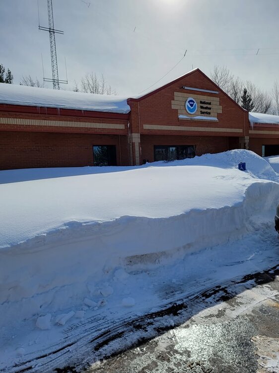
-
Not to take anything away from Marquette, but the NWS office is in Negaunee, just outside Marquette city but the elevation/upslope conditions make it a snow microclimate. The NWS office probably averages twice what the city of Marquette averages.
-
Indeed the seasons were VERY back and forth (per what info is available) pre-1850....and again in the 1870s-1880s (now with accurate data to back it up).
-
Do you by chance have a record for Detroit from 1836-1869? Official obs did not begin for Detroit until Nov 1870, and the NWS lists them as starting in 1874 (not sure whats wrong with 1870-73). I wonder where the data was taken in those early days? I wonder if it was taken by a max/min thermometer or like they sometimes did wayyy back, take just 3 obs a day? As I have mentioned, a book I have details the weather from 1837-1887, and its a fascinating read, but I dont have the actual monthly records (or know where they were taken). They describe summer as having some days with a tropical atmosphere as hot as the equator but that they dont last before pleasant weather kicks in. Many winters are mentioned as "open" winters with little snow, some are noted as harsh winters. It would not surprise me if there were far more droughts/low snow years 200 years ago than there are now in what was a colder/drier climate. Takeaways from those numbers, albeit the small sample size of the early 1800s data and their unknown origin means it should be taken with a big grain of salt: ~winter, BY FAR, is the least warming season and summer is by far the most warming season. (I have been saying this for years and yet every now and then a bogus article will still pop up about winter warming faster than any season in the Great Lakes. This could not be further from the truth) ~May to Oct is the time of year that has warmed the most ~Jan, amazingly, is currently colder at both Detroit and Port Huron than it was in the 1830s-50s. This is the only month that has not warmed some.
-
Spring 2023 Medium/Long Range Discussion
michsnowfreak replied to Chicago Storm's topic in Lakes/Ohio Valley
Near normal would be great. I want open window weather. Every year we have late spring cold snaps followed by heat. Remember 2020? -
I had a 5:1 ratio 6" snowstorm this winter that my snowblower couldn't handle so I had to shovel. 30" of 5:1? Bo might as well hunker in and let the May sun take care of it the next week lol.
-
This may snowstorm was historic even for the UP, and its a great lesson in geography because the storm was HUGELY dependent on elevation and proximity to the lakeshore. Just looking at pics and comments on nws mqt Facebook page, the variability is wild. Naturally, you're the winner.
-
I love reading about those old pre-record days. I have a book by bella hubbard called "memorials of a half century" which details his time in the detroit area from 1837 to present-day 1887. It's fascinating and he goes into detail on weather/seasons. Maybe in the summer if I have time I will do a post detailing some of that. May 2020 had snow fall on 5 days (consecutively no less) which had never happened before (May 8-12, with 0.5" on the 10th). May 2016 had exceptionally late snow (15-16th). The latest official flakes for Detroit were May 31, 1910 and the latest measurable was an incredible 5.0" on May 21/22, 1883.
-
Midday. There was snow, graupel, sleet, and rain here. I see it's snowing in howell now.
-
May 1st. This is the 3rd May since 2016 to see snow.
-
April 2023 General Discussion
michsnowfreak replied to PositiveEPOEnjoyer's topic in Lakes/Ohio Valley
DTW hit 30, which missed the record by 3°. Freezing fog overnight. Most places in the 20s. -
Good stats. Now I will say that the past 5 years have definitely had an abnormal amount of very late season snow. But I think April expectations are too high in the Great Lakes. A typical April is quite gray and features a roller coaster of temperatures ranging from summer to winter.
-
Spring 2023 Medium/Long Range Discussion
michsnowfreak replied to Chicago Storm's topic in Lakes/Ohio Valley
Im going to be doing some research on late snowflakes here. They have absolutely become way more frequent than I remember. lets see how accurate my memory is. -
Spring 2023 Medium/Long Range Discussion
michsnowfreak replied to Chicago Storm's topic in Lakes/Ohio Valley
Lol we did get a widespread white Christmas this past year. Jokes aside though, late spring flakes are definitely common in recent years. -
April 2023 General Discussion
michsnowfreak replied to PositiveEPOEnjoyer's topic in Lakes/Ohio Valley
Incredible! -
April 2023 General Discussion
michsnowfreak replied to PositiveEPOEnjoyer's topic in Lakes/Ohio Valley
Awesome aurora pics guys. More flurries this morning


