

michsnowfreak
-
Posts
18,382 -
Joined
-
Last visited
Content Type
Profiles
Blogs
Forums
American Weather
Media Demo
Store
Gallery
Everything posted by michsnowfreak
-
I have to agree regarding november especially. Each winter has its own mind and no two are exactly alike, but I under no scenario can I see November's snow and cold, or lack thereof, as having any correlation to the coming winter.
-
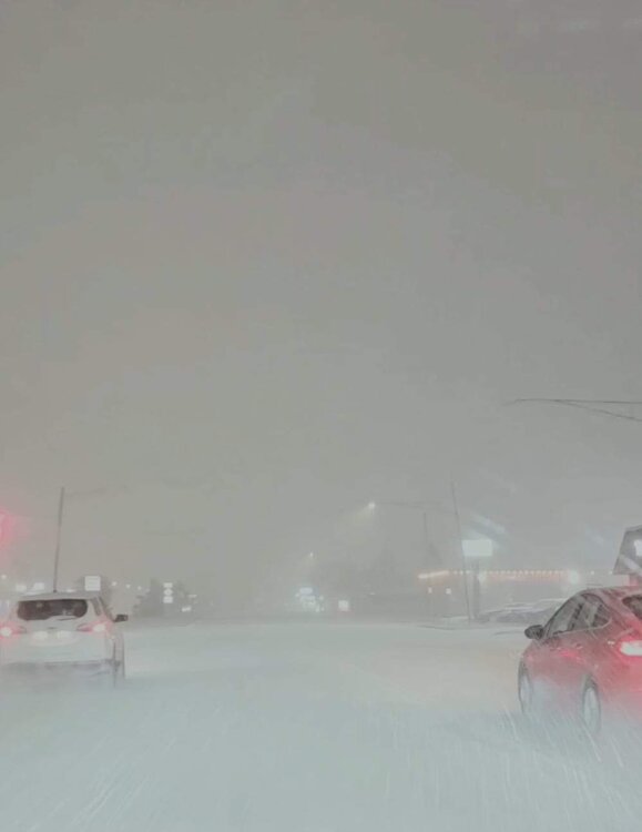
It was legit. It was almost like an unintentional storm chase for me. My brother wanted to go downtown Detroit to dinner and check out the Christmas stuff. The squall hit as we were out, and it was such a perfect atmosphere. I figured the band would weaken some as it headed south but still snow, but instead it strengthened. As we left Detroit it had tapered to flurries but we ran right into it and drove through it the whole way home, Visibility near zero by my house briefly. It was enough to disorient you if you didn't know where you were because the traffic lights were obscured until the last minute.
-
Snow squall warning verified here. Had a great time. Went to Detroit to Campus Martius to check out the Christmas stuff and did it in heavy snow, then followed the squall home. After all day snow flurries and light snow dropped 0.1" following yesterday's 0.2" slush, the squall dropped a quick fluffy 1.6" of snow.
- 264 replies
-
- 16
-

-
Lightly snowing and blowing today creating a wintry feel. Looking forward to see what kind of lake response/banding we get this evening as a shortwave moves thru.
-
Not to speak for bo, but i would think it would have to be a very warm start to spring for him to have bare ground in mid April. Also, this seems late for his winter snowcover to be laid down.
-
Started as a few hours of rain here then to wet snow. 0.2" of slushy snow here. 0.5" DTW. Away from the water most of SE MI got 1-2", but this is not uncommon for a November snowfall.
-
I expect pics!
-
Haven't had snow since Halloween, though the ground has snow on it November 1st. It's gonna be a sloppy white rain in dtw but I'm interested in les band potential tomorrow
-
13-14 was the most severe winter on record at Detroit. 14-15 smashed records in the east while the midwest had the coldest Feb since 1875 or of all recorded history (depending on location). In 2019 a record smashing arctic blast hit the midwest, and it was record smashing during already what is the coldest part of the year. And in Feb 2021 Texas lost their shit when temp records broke by 20+ degrees in the Arctic blast. That is all less than a decade ago. There is absolutely no reason to believe that when the ingredients are right the east won't have a brutally cold winter that's on par with other cold winters of the past few decades. And no, I'm NOT saying I think that happens this winter. And no, I'm not denying anything (ugh I hate that I even added that part in there, like it's mandatory on here when you talk of cold weather).
-
Great post. Happy Thanksgiving all!
-
A very interesting tweet considering this thread is page after page from mostly the same group of mets and their clear biases. I don't even know who most of them are but by this thread alone as soon as I see the name I can guess where it's going. Also as an aside...speaking of "colder snowier" winters in the east, I imagine that the line is drawn somewhere near Boston where temps, troughs and ridges arent the end all. Obviously winter lovers want snow AND cold. But even in warm winters places north of 40N can get plenty of snow. Saw nearly 40" in Detroit last winter in a MUCH warmer than normal winter. I feel like a lot of bad luck hit the east coast in addition to warmth and that's fresh in people minds. Part of the fun is that each winter is full of unknowns and this one has even more than usual.
-
It's almost a given that this Winter will be better for them than last year for them. I think this winter will be colder here than last winter. Snow is the wild card
-
 You can get something similar with a paid subscription to WeatherBell (among other neat stuff), but ive not found anything free.
 -
It's actually tiresome that this has to literally be stated as a preface anytime someone challenges one of the more off the wall predictions, statements, or even interpretations regarding climate.
-
Winter 2023-24 Longrange Discussion
michsnowfreak replied to michsnowfreak's topic in Lakes/Ohio Valley
To be fair they actually do give reasoning many times though. It's a lot more than some here do. Like stebo said, absolutely no way to know what December in its entirety will bring. But I'd bet on something changeable. -
Interesting. I wonder if they have stats on how cloudy October was? I'd say it had to be up there. Most stations don't do % of sun anymore.
-
Winter 2023-24 Longrange Discussion
michsnowfreak replied to michsnowfreak's topic in Lakes/Ohio Valley
If I had to pick the absolute worst winter to experience here all things considered, it would likely be 1881-82, 1889-90, 1918-19. Not sure if any were ninos. I would say 1982-83 was worse than 1997-98, and both were worse than 2015-16. -
Winter 2023-24 Longrange Discussion
michsnowfreak replied to michsnowfreak's topic in Lakes/Ohio Valley
Based on? -
What station is that?
-
Winter 2023-24 Longrange Discussion
michsnowfreak replied to michsnowfreak's topic in Lakes/Ohio Valley
This year isn't behaving like a usual nino anyway. Let's take things one step at a time -
November has been very benign. After starting with a dusting of snow on the ground, there has been quite a bit of sun.
-
Winter 2023-24 Longrange Discussion
michsnowfreak replied to michsnowfreak's topic in Lakes/Ohio Valley
Bite your tongue (unless Jan-Feb 2015 follow) -
Winter 2023-24 Longrange Discussion
michsnowfreak replied to michsnowfreak's topic in Lakes/Ohio Valley
From the new England forum, it appears December starts cold before a few weeks flip to milder then colder and stormier towards Christmas. -
In 18-19 there was a record cold snap during the dead of Winter in the midwest, nino and all.
-
That sounds like 2 weeks behind here. Is it common on the lakeshore? I'd guess the same is seen in terms of a delay in spring blooming?


