nrgjeff
-
Posts
4,248 -
Joined
-
Last visited
Content Type
Profiles
Blogs
Forums
American Weather
Media Demo
Store
Gallery
Everything posted by nrgjeff
-
Mid-level clouds Chattanooga. Houston Hobby (middle of town) 27 deg. SN+ which is unbelievable down there. Not wet snow. Dry blowing Midwest snow and 4+ inches coming. Isolated 6 at those ratios. Then 6+ is coming to Nola. Time to live vicariously in the Central/West region. Blizzard Warning Gulf Coast Beaumont to Lake Charles! This a truly special event down there.
-

Fall/Winter Banter - Football, Basketball, Snowball?
nrgjeff replied to John1122's topic in Tennessee Valley
Excellent. We need to look out for our neighbors in NE Tennessee and WNC still left out in the cold (literally by FEMA) after Helene. Yeah that's weather related. Our church partners with another down the street when disaster strikes Chattanooga or the region. We must help! As for sports, snow both NFL games today. Winning! -
Chatty had flurries and snow showers during the 4:00 pm hour. Not much attm. Oh yes, everyone please post more slow-motion snow videos. Slo-Mo is the new obligatory deck photo, haha!
- 207 replies
-
- 10
-

-

-

-
- obs
- light snow
- (and 2 more)
-
Keep getting well BuCoVaWx. Perhaps a wild winter will bring cheer. I joke about Chattanooga, but we're playin' with house money after January 10th.
- 207 replies
-
- 6
-
-

-
-
- obs
- light snow
- (and 2 more)
-
Guess what's happening in Chattanooga. Cloudy, windy, and cold. Nothing more than a few snow grains.
- 207 replies
-
- 7
-
-

-
-
- obs
- light snow
- (and 2 more)
-
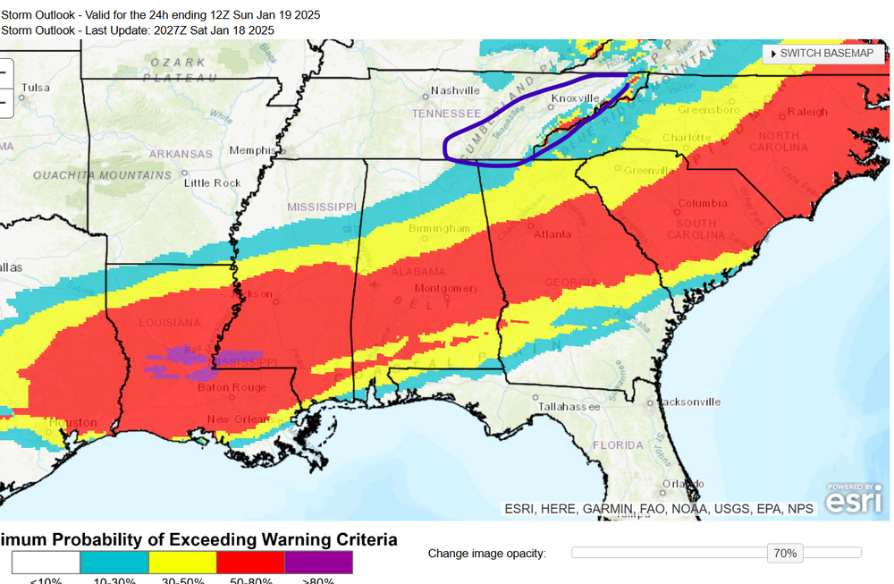
Severe weather baby! ^^ Alright to Tuesday. Gonna let Sunday live in the Jan. 19 RGEM thread though I know it's flexible. Looks like more like moisture will be around for light snow in more places on Sunday, but it's covered in that thread. For Tuesday I share the probability of WS Warning from WPC. The cut-off at Tennessee isn't a jinx, haha. Alabama and Georgia have that low 2-inch criteria. So if there's nearly a 30% chance up on the Tennessee border; then, maybe a little light fluffy snow East Tenn. Again this is for Tuesday and Tuesday night. End of NAM (I know lol) hints at a little more moisture up our way like the Canadian. Otherwise we'll be happy for the Deep South. I'd pick Birmingham over ATL because nothing ever goes right in ATL. Also be north side of centerline, but yeah ATL looks good this time too.
-
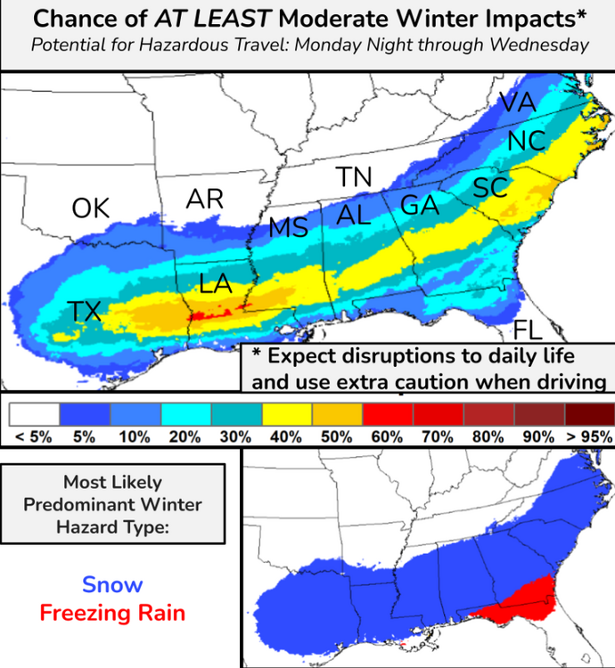
WPC tease me and maybe even please me. That's moderate impacts. Light impacts probs are likely higher. Fluffy snow doesn't do much except for roads. Reel it in! Then North Florida Red Alert. Icemageddon!
- 207 replies
-
- 3
-
-
- obs
- light snow
- (and 2 more)
-
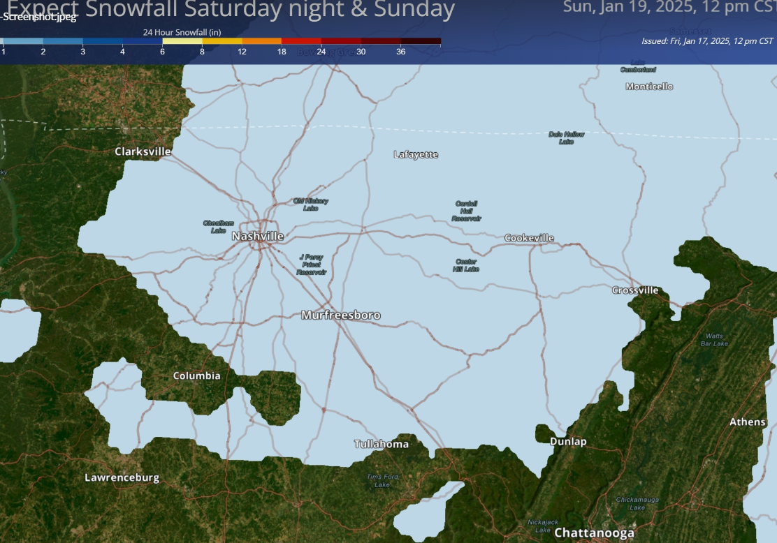
Nashville just dropped higher snow probs. Surely this is coming to their public site soon. Ope! I cut off the scale, inch or less.
- 207 replies
-
- 5
-
-
-
- obs
- light snow
- (and 2 more)
-
Indeed it's nice to be playin' with house money. Southeast Tennessee certainly is, even if other parts of the forum don't feel the same (yet). If we get it great! If not I'll be happy for the Deep South. But yeah, I think we have a shot still. I figured you were. Great stuff! Soon, maybe as early as in February, we can focus on the Dark Side of the Force.
-
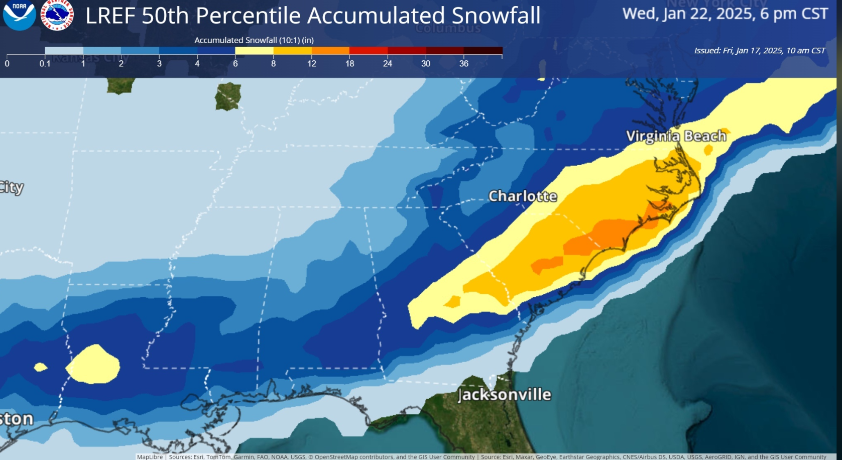
Let's try this. It might be fixed last page too. Model trends are south for Tuesday. Sometimes the Deep South gets it and we don't, so we can be happy for them. I don't even want to look at the late week mess. There is still a chance Tue/Wed though. LREF from NWS. I'm not sure where this lives on their website so I'll share.

-
Yes because we are buried in Arctic high pressure during the middle of the cold wave. Model trends are south for Tuesday. Sometimes the Deep South gets it and we don't, so we can be happy for them. I don't even want to look at the late week mess. There is still a chance Tue/Wed though. LREF from NWS. I'm not sure where this lives on their website so I'll share. PS. other Pinned thread is just for Sunday right?

-
Don't worry I'm still Snow Jeff. I was just lmao to see others jawboning severe. My favoring the Canadian model is for that snow up into Chattanooga, and elsewhere in our Region. Oh Canada!
-
Y'all are starting to sound like me! Welcome to the Dark Side. AI versions pretty much followed their ops versions. Whatever. I'm going with the Canadian. Sounds good, eh?
-
Canadian was first to sniff out Mid South clearing for the total solar eclipse. Oh Canada baby!
-
Laugh. Cry. Throw the device. One reality check is Tennessee Valley temps are not forecast as cold as with Heather and Elliott. Perhaps that's less support for a snow down on the Gulf Coast. Of course they could get a bowling ball in the southern stream. Then if we get something as the jet stream lifts back north, I will vomit if we get warm nosed. Still holding onto a middle scenario with light snow for Tennessee midweek.
-
Model spread has gotten worse the last 12-18 hours, but that does not necessary decrease our odds of success. Appears the middle solution is still a chance of snow. Between Deep South blanks Mid-South, and that atrocious warm nose crap late week, there is a mid-point of light snow southern Tennessee midweek. Of course, all of our Region is clearly within the bell curve. If all else fails. Shit my brain is oat-meal from looking at models. WPC has a 30% chance of snow in the Deep South Days 6-7. North side clips us. One would have to include all of us in the 10% north side. The other 10% is snow south of I-20 and Deep South mayhem. My professional focus has to be temperatures next week; so, I'm not drilling down the snow forecasts more than once a day. We are watching temperature forecasts like hawks. If this thing develops, I'll have a lot more on snow this weekend.
-
The PWAT charts above do not kill Tennessee snow chances. Remember snow, especially dry snow, carries very little liquid compared to rain. I hope central Mississippi can score. It's even more magical in the Deep South. Then I want to get TROWAL'ed over here in East Tenn. TROWAL me! Talk dirty to me.
-
The 18Z GFS can go to Hell! Meanwhile AI versions of both continue to improve and jog north. If we go from I-20 to cutter before it gets here, I'm going to quit the forum. I believe one wave will settle in well over us. I still think the Deep South could get one before us too. This far south jet stream would be their pattern. On the retreat north we can score as long as it's not too north like 18Z. Consensus remains good or even south - right where I like it a week out.
-
Solid until - unlikely we receive much. Though at 25 deg. a tenth inch QPF is 2-3 inches of snow.
-
Models have been improving the last 12 hours since my last post. Looking at Ops AI and ensembles. 06/12Z GFS have a true TROWAL behind the main WAA later this week - a recipe for several inches of snow. Other models have light overrunning. Few blank us now. Few details. Work is really busy. I'm also following current events - but for that you'll have to visit Randy's hood to see my thoughts.
-
Model trends encouraged me today. Per my last post, I'm much more interested in midweek than Sunday. Southeast Tennessee needs a new system, not one chasing the Saturday rain. Ensemble members and some ops and AI runs are delivering a midweek system. Others keep it buried in the Deep South. Again I'd much rather be concerned about moisture getting north, rather than warm noses and cutters. That's all for today. Long day at the office, but I was watching trends. I'll sleep happy tonight.
-
12Z Canadian shows ice! What is that Trudeau's retaliation? GFS and Euro I see Sunday as the first chance of winter precip. Perhaps late Saturday night northwest so that's still Day 7 as of this writing. I like the Peachtree discussion. At the same time the ensemble snow means are increasing per Carvers above. Personally I'm hoping for something the middle of next week to show up in the flow. Sunday is way too soon after the rain system for KCHA. We'll be fighting subsidence behind the first system; plus, anafrontal is DOA for Chatty snow.
-
Strange. Hall is never bullish about anything. Chattanooga probably has reached our half-way point even if the good models verify. Other parts of the forum may be just gettin' started. We'll see.
-
Even that 12Z GFS verbatim, buried in the Deep South, more snow than progged would get up and over us. Northern stream, maybe instead of warm nosing us, could do something productive (for once) in that setup.
-
November snow in Florida! per a few posts up. Guess anything can happen in this business. Quick look at the medium range models and most bury any waves. I'd much rather see that than cutters. Perhaps one will develop in our sweet spot. A couple AI versions have just that. Right after the Saturday rain, but separated enough to develop, second wave Sun/Mon.