

Terpeast
-
Posts
6,618 -
Joined
-
Last visited
Content Type
Profiles
Blogs
Forums
American Weather
Media Demo
Store
Gallery
Everything posted by Terpeast
-
That’s going to be a lot of work and take a lot of resources. Near misses can happen both ways - cutters or suppressed waves. And a near miss for SNE can be a direct hit on the MA, and so forth. Not saying it can be done, just that it would need academic research plus reanalysis modeling. Minimum months, likely years of work.
-
How does that vibe compare to what we have now this year? I remember last year was pretty muted, we knew that it was going to suck (albeit not as hard as it actually did)
-
If this winter finds a way to fail, it won’t be for lack of storms. It’ll be the cold air
-
subsurface has been warming lately, no?
-
Yeah, that's what I was debating with bluewave about. I think ENSO is going to win out, even if it peaks moderate or low end strong. The atmospheric response will drive the SSTs instead of the other way around, and there are signs of this already happening.
-
Great work @griteater A little surprised that +PDO/+ENSO actually produced milder winters in the past. One thing that could explain this is the aleutian low being too strong and too close to the west coast.
-
One of the two, or both
-
And that ridge NW of Hawaii has got to go, too.
-
I thought 2004-05 was an okay winter for the MA by today's climate standards. We got a couple of low-end warning events down here, along with a few advisories. KIAD totaled just over 17", with most of it in J & F.
-
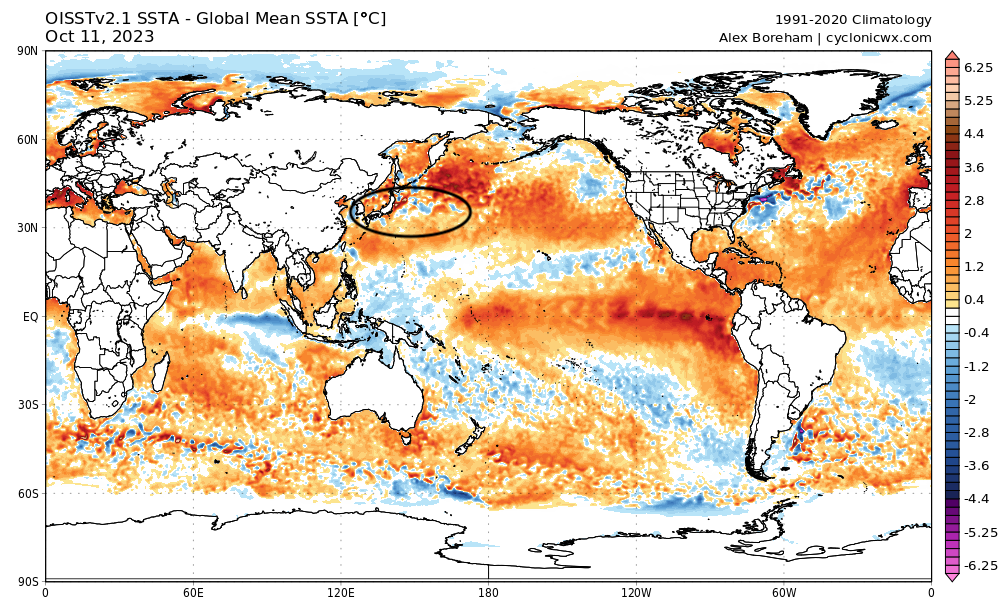
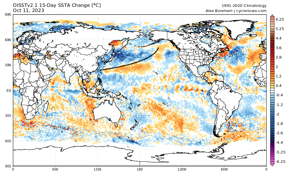
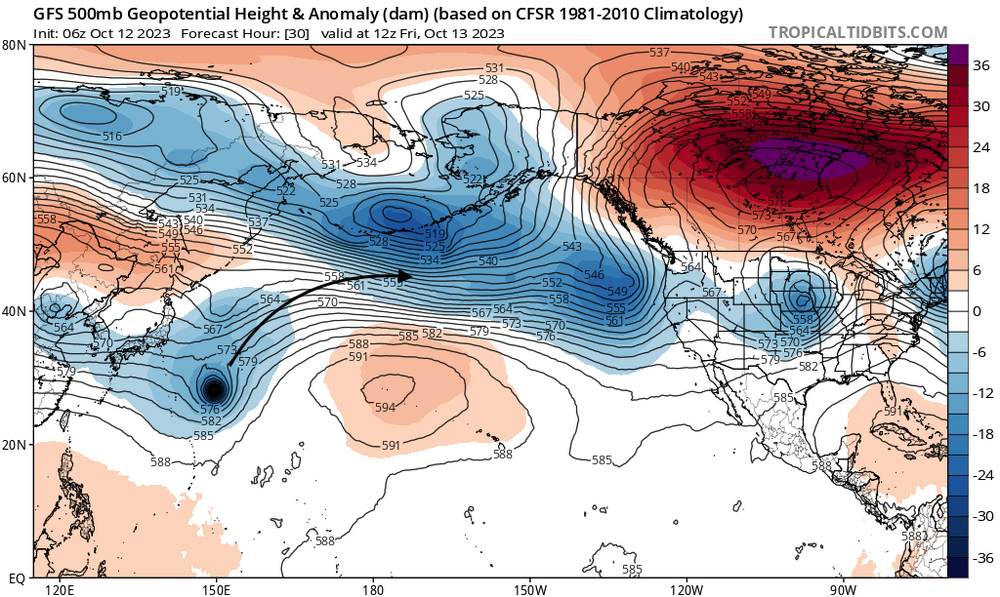
Pacific continues to change. Marine heatwave off Japan is starting to break, and some of that heat is getting displaced to the NE of Japan towards the aleutians. Strong cooling is still taking place from Japan all the way out to south of the aleutians. Typhoon is modeled to recurve towards the aleutians, which may help dissipate some of that warmth up there. The only problem is that stubborn high to the NW of Hawaii. Ensembles seem to break it down past day 10, but since it's beyond day 10, we'll have to wait and see on that.
-
That I agree with. We'd just have to wait them out if the polar domain ends up in our favor
-
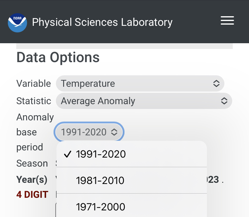
Fair. But my opinion is that the climate normal period ought to be centered around the analogs you’re using. For 94-95 and 04-05, I believe we should probably use 1991-2020 particularly if you’re comparing them with years like 09-10 and 14-15.
-
Ok I see you’re subtracting 2002, 2009, and 2014 from the other 2 winters. I thought they were a composite of all 5, and it didn’t make sense that the warm anomalies seemed grossly exaggerated. I’m 95% sure we’re not looking at another +5 DJF winter this year. +2 probably.
-
That doesn’t make any sense. You can change the climate normal period before you render the plot.
-
Why are you using the 1971-2000 climo when 4 out of those 5 winters are later than 2000?
-
Yes, and the qbo is double digit negative and falling is a good sign.
-
I’ll have to look at the ao/nao numbers again for that season, but given How drastically different the 3 seasons I raised here is proof enough that the polar domain is going to be a determining factor for 23-24 given the enso and pdo similarities across all three. Bluewave and I were just looking at both sides of the same coin here.
-
That time frame was when it started flipping. I was looking all the way back to mid 2007 when the PDO went negative, deeply so, and remained that way until around summer 2009, when the el nino atmospheric response began to assert itself right in that autumn timeframe.
-
I also looked at the PDO index leading up to each winter, and before 09-10, there was a long duration strong negative PDO before becoming neutral. So I think the atmospheric response to the el nino was driving the bus that winter, and the pac ssts was just a response to the aleutian low, which was a response to the forcing from the CP nino. I don’t think the pdo ssts are the driver unless they are extreme.
-
2009-10 was similar, except the polar domain (nao) was negative while 04-05 & 94-95 was raging positive. That was the difference, and not so much the tropics or pacific.
-
No need to get so worked up because I used a different matching tactic than you did, and I haven’t even gotten to the maps part of my whole analysis yet. I already spent 3 hours on collecting the variables that I think are important, and it’s getting late. I’m not going to pull an all nighter just to complete the analysis the way you think should be done. Chillax. Sheesh.
-
I think you guys are going to like the analog matches I've found for this winter based on ENSO, PDO, QBO (and whether it is rising or falling), MEI, ONI vs. Nino 4 (where -vp forcing is favored)
-
Did a prelim analog analysis... Collected all El Nino years, from weakest to strongest, and cross ref'ed them against MEI, Nino 4, difference between ONI and Nino 4 (to see if it was east based or not), PDO, QBO, AMO, preceding base state (whether the nino came after multi-year ninas and -PDO regimes). Once I filled in all this data, I filtered out all the east-based ninos, +PDO years, and +QBO years... any MEI lower than 0.5 and any higher than 1.1. I got only one analog match: 2009-10. Not a perfect match by any means... but it's all I've got right now, and I'm certainly not going to base my winter outlook just on one season. So I'm just going to wait for another month's worth of data, and loosen my matching criteria to include more analog years so I could use a mix of at least 5 seasons. Now if I ignore the QBO, I get: 94-95, 04-05, 06-07, and 09-10. At least the latter three had "falling" QBO, so I could exclude 94-95 based on which direction the QBO was evolving those seasons.
-
QBO came in at -13.58 for Sept. Still falling.
-
Yeah, I don't think it's best to use past volcanic analogs like Pinatubo in 1991-92 because that was a different type of eruption with sulfur not H2O vapor.


