


Terpeast
-
Posts
6,754 -
Joined
-
Last visited
Content Type
Profiles
Blogs
Forums
American Weather
Media Demo
Store
Gallery
Everything posted by Terpeast
-
The Weekend Rule? Saturday 2/17 - The Icon Storm
Terpeast replied to DDweatherman's topic in Mid Atlantic
Is this where we say “uh oh” and root for a 4th last minute south trend? this is the ICON thread after all… -
The Weekend Rule? Saturday 2/17 - The Icon Storm
Terpeast replied to DDweatherman's topic in Mid Atlantic
Good run, but careful not to get any further amped else we'll either have temp issues or the best banding goes north of DC -
The Weekend Rule? Saturday 2/17 - The Icon Storm
Terpeast replied to DDweatherman's topic in Mid Atlantic
0.5" qpf from harrisonburg through winchester through Loudoun and MoCo -
The Weekend Rule? Saturday 2/17 - The Icon Storm
Terpeast replied to DDweatherman's topic in Mid Atlantic
850mb low just south of us, precip almost ending in DMV. Not longer duration, but maybe a heavier thump -
The Weekend Rule? Saturday 2/17 - The Icon Storm
Terpeast replied to DDweatherman's topic in Mid Atlantic
Heavier precip at 36, could be a longer duration than previous run Now I see an 850mb low -
The Weekend Rule? Saturday 2/17 - The Icon Storm
Terpeast replied to DDweatherman's topic in Mid Atlantic
SLP further back and 2mb stronger at 33 Big difference at 500mb. Previous run was flat and diffuse, now it's a bit more amped and further west -
The Weekend Rule? Saturday 2/17 - The Icon Storm
Terpeast replied to DDweatherman's topic in Mid Atlantic
30-35% chance for 4” or more in dc/balt. I’d take those odds -
The Weekend Rule? Saturday 2/17 - The Icon Storm
Terpeast replied to DDweatherman's topic in Mid Atlantic
Looks on par with Jan 19 to me, if memory serves correctly. If this verifies or trends any bit wetter, we have a low end warning event. LWX may not go that far because its a saturday -
The Weekend Rule? Saturday 2/17 - The Icon Storm
Terpeast replied to DDweatherman's topic in Mid Atlantic
So far models are trending for the better. 36-42 hours out -
The Weekend Rule? Saturday 2/17 - The Icon Storm
Terpeast replied to DDweatherman's topic in Mid Atlantic
With the qpf and soundings you just posted, their snowfall output is probably wrong (again, it means nothing as far as verification) -
The Weekend Rule? Saturday 2/17 - The Icon Storm
Terpeast replied to DDweatherman's topic in Mid Atlantic
Ukie qpf actually looks about in line with the other models -
The Weekend Rule? Saturday 2/17 - The Icon Storm
Terpeast replied to DDweatherman's topic in Mid Atlantic
Post it for everyone to see... -
The Weekend Rule? Saturday 2/17 - The Icon Storm
Terpeast replied to DDweatherman's topic in Mid Atlantic
LWX has our low end being 1" and high end 5" in the dc/balt metros -
The Weekend Rule? Saturday 2/17 - The Icon Storm
Terpeast replied to DDweatherman's topic in Mid Atlantic
Looks south of what it was before, unless I got my wires crossed up with another model. Still think forum wide is good for 2-4" and northern tier get better ratios -
The Weekend Rule? Saturday 2/17 - The Icon Storm
Terpeast replied to DDweatherman's topic in Mid Atlantic
If that verifies, someone along the m/d line is getting 7”+ -
The Weekend Rule? Saturday 2/17 - The Icon Storm
Terpeast replied to DDweatherman's topic in Mid Atlantic
I'll happily take a 2-4er -
23.7 low, heavy frost. 36 now
-
Ironically, I think CC will do it. But who knows what will come next
-
Not if the west pac warm pool and seas off Japan remain boiling. And a strong nina will just concentrate warm waters in the MC
-
I’d want to see wholesale changes in the pacific and for those marine heatwaves to cease before thinking anyone east of the rockies get a snowy winter. At least the PDO has been less negative recently, but I’d want to see it firmly in positive territory.
-
Late Feb/March Medium/Long Range Discussion
Terpeast replied to WinterWxLuvr's topic in Mid Atlantic
Its certainly possible. March waves tend to be crazy amplified but timing with cold air will be tricky esepcially this year. I’d be happy with one more chance to play in the snow with my daughter and call it a winter, though. That’s where my head’s at now -
Late Feb/March Medium/Long Range Discussion
Terpeast replied to WinterWxLuvr's topic in Mid Atlantic
Could be the last chance then that’d be all folks -
The Weekend Rule? Saturday 2/17 - The Icon Storm
Terpeast replied to DDweatherman's topic in Mid Atlantic
Yep getting interesting. A little south trend won’t hurt. Wiggle room! -
What Went Wrong in Winter 23-24/Base State/Will It Ever Snow Again??
Terpeast replied to WxUSAF's topic in Mid Atlantic
Agree. Glimmer of hope is that we may not have to wait that long for the -pdo to end. CC may be causing more variability and quicker flips between + and - Plus according to this graph, we’ve been in a neg pdo since following the 1998 super nino. Hard to tell and data before 1930 or so is likely suspect, but the cycles were prolonged in the past, and they seem to be shortening over time. 1840-1880: neg for 40 years 1880-1910: pos for 30 years 1910-1925: brief neg for 15y 1924-1945: pos 20y 1945-1975: neg 30y 1975-1998: pos 23y 1998-now: neg 26y but with brief 2-4 year interruptions I suspect that it won’t be long until it flips back, but the positive cycles will become shorter each cycle, same with negative. wild card is in the marine heat waves, those may change things in unforeseen ways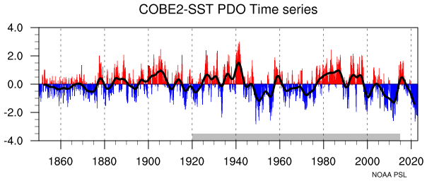
-
Cool, just downloaded too. I’ll get on the rapid rewards tomorrow too. Getting ready to get some free flights next year, wherever that may be!
- 2,509 replies
-
- 1
-

-
- weenie fest or weenie roast?
- weenies got roasted
- (and 2 more)

