Terpeast
-
Posts
6,682 -
Joined
-
Last visited
Content Type
Profiles
Blogs
Forums
American Weather
Media Demo
Store
Gallery
Everything posted by Terpeast
-
Zero signs that the Japanese marine heat wave is ending. Looks like a carbon copy of 2022-23
-
Low of 34, but frost everywhere.
-
Late Feb/March Medium/Long Range Discussion
Terpeast replied to WinterWxLuvr's topic in Mid Atlantic
Just graded my 23-24 winter outlook: -
Terpeast's 2023-24 Winter Outlook - Overall Grade: C
Terpeast replied to Terpeast's topic in Mid Atlantic
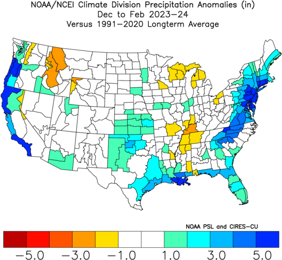
Grading my 23-24 winter outlook vs actual results Temperatures: Decent match spatially, but off on the magnitude of the warmth. It's not just us being really warm, it's everywhere. Including Canada. Grade: B- Precipitation: Good match spatially and magnitude, a little bit off on the precip maxes though both midwest and east coast. I was highly confident of a wet winter, and that did happen. Grade: A- Snowfall: Truth is, I had at least one big storm baked into my snowfall outlook even through I cited only a 15-30% chance of a HECS. Well, that didn't happen obviously, so my snowfall guess was shot to hell. Grade: F Overall: I think my methodology and use of MEI led to an OK outlook, but was a little overconfident on blocking. We did get blocking, but each episode was either too brief, or occurred in the wrong places. Unfortunately, the MEI is no more, and I will have to either use RONI or a different method altogether for next year's outlook. Overall grade: C
-
What Went Wrong in Winter 23-24/Base State/Will It Ever Snow Again??
Terpeast replied to WxUSAF's topic in Mid Atlantic
Yeah, I’d have to compare my conus temp/precip maps in my outlook vs actual, should be a decent match. What went wrong was my snowfall outlook had baked in at least one big storm. Which didn’t happen. -
Low of 27
-
Low of 29. No frost because its so dry
-
Smoke in ashburn. Where are the fires?
-
Early peak and decay may give us a modoki nina, worst case scenario for the east if you like cold and snow.
-
Late Feb/March Medium/Long Range Discussion
Terpeast replied to WinterWxLuvr's topic in Mid Atlantic
Repeat of last years canada wildfires? -
Thanks, that gives me a clue to which analogs would make a good starting set and add others based on QBO and PDO (and of course, adjust each warmer by a couple degrees...)
-
Quite the turnaround. >60% nino to >60% nina within 3 months. Has such a transition happened that quickly before?
-
Still a warm signal. Even if only +2 based on older analogs (pre 2016 super nino), one would need to adjust to today’s climate. Like +4 or something like that.
-
In like a lamb--out like a Lion. March 1958 redux long range thread
Terpeast replied to Ji's topic in Mid Atlantic
That’s not wrong -
Yeah, I was disappointed as well. Even though I busted way too high on my snowfall outlook, looking back at how I based my CONUS temp and precip maps on the MEI, I think it actually proved an useful tool that led to fairly successful verification at least with the distribution of temp/precip anomalies. Enough to make me think that I can use it again in future outlooks... then they take it away.
-
Wow, that is news. I guess I won't be using the MEI for future outlooks then. Might have to go with RONI or use my own custom dataset or something. Bring it on. I'm not expecting a winter next year imby, so might as well go ape with this nina and hopefully the strong trades push those cooler waters all the way into the maritime content / west pacific warm pool while we're at it.
-
Saw a few flurries yesterday afternoon and lots of wind this morning
-
What Went Wrong in Winter 23-24/Base State/Will It Ever Snow Again??
Terpeast replied to WxUSAF's topic in Mid Atlantic
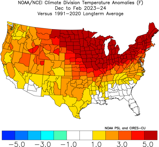
Next winter the sfc temp anomaly may look pretty much like this map if the pacific doesn't change and we get a +qbo nina. Could be historically warm and snowless for the immediate east coast up to coastal SNE. At some point, we've gotta get a dip that breaks the climo trend. Don't know when that's gonna be. -
In like a lamb--out like a Lion. March 1958 redux long range thread
Terpeast replied to Ji's topic in Mid Atlantic
It’s very likely too late for a lowland snow, but I’m interested in the AIFS test case, too. -
What Went Wrong in Winter 23-24/Base State/Will It Ever Snow Again??
Terpeast replied to WxUSAF's topic in Mid Atlantic
And yet he understands more about the climate and its trends than most mets and atmos scientists do. -
Late Feb/March Medium/Long Range Discussion
Terpeast replied to WinterWxLuvr's topic in Mid Atlantic
I’m not sure if it will be even as long as one paragraph! -
Late Feb/March Medium/Long Range Discussion
Terpeast replied to WinterWxLuvr's topic in Mid Atlantic
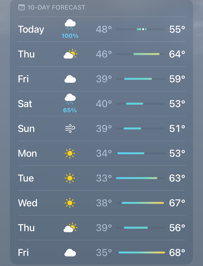
10 days. Last 3 are warm, and that’s going to verify for sure. Maybe even warmer Crap, i was using metric (been overseas for too long) here’s the fahrenheit version lol
-
Late Feb/March Medium/Long Range Discussion
Terpeast replied to WinterWxLuvr's topic in Mid Atlantic
As a rule of thumb, if I don’t see cold/BN temperatures in all of the last 3 days within my apple weather app, we’re not seeing cold anytime soon. Following this ^^ rule would have been much more accurate than models. -
Late Feb/March Medium/Long Range Discussion
Terpeast replied to WinterWxLuvr's topic in Mid Atlantic
We may hit 70 next week -
Of course, I’ll be out of the country most of April. So it’ll be a fun month for everyone here.