Dark Star
-
Posts
1,731 -
Joined
-
Last visited
Content Type
Profiles
Blogs
Forums
American Weather
Media Demo
Store
Gallery
Everything posted by Dark Star
-
I wonder if Volcanic Winter can shed some light on whether the Alaskan Volcano potential eruptions on MSN is just "overblown" hooey?
-
For what it's worth, north central Canada is harboring -27 degrees air this afternoon.
-
Another potentially pleasant day ruined by the wind...
-
I don't know. It just seems windy all too often over the last 10 years, or so. Maybe I notice more since I have less hair?
-
I was covering the overnight shift at CBS. I saw the LFM and pointed out to Steve Deshler that it looked like a major snowstorm was going to hit us. Irv Gikofsky walked in and just laughed at me...
-
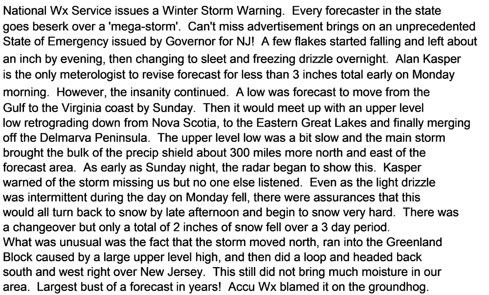
Busted isn't quite the word. See my write up from earlier today. Correct my breakdown as you see fit...
-
I guess just from a relatively brief downpour?
-
I do remember hearing Brooklyn actually got some snow out of it...
-
Today marks the anniversary of the biggest bust of all time in the NYC metro area (2001).
-
So the bulk of the rain today stays to our west?
-
There is some cold air up in Northern Central Canada, but also a very cold pool of air along the St. Lawrence Valley. The cold pool of air along the St. Lawrence valley appears cutoff since the air gets "warmer" the farther you approach the Hudson Bay area. Just hoping there is some source of cold air to tap into (just in case).
-
Walked my dog. 3 layers and was pretty cozy, except for one street which is a wind tunnel. Last gasp of cold air?
-
I assume that general temperature profiles can be extracted through trees, Ice Cores, sediment cores? I would trust data collected and assessed from before 1980, only because perhaps there could be a bias trying to prove an agenda *after that date). Sorry for my cynicism. I am among the minority of conservatives that A. there is global warming, and B. it is attributed to greenhouse gas emissions. I could be wrong, since there is varying data, of which I am not an expert in. The graph/chart/depiction that we are all "discussing", in and by itself, can make an argument both ways.
-
Wow, 9 pages for March, and it hasn't even begun. There must be a lot of weather going on...
-
The main point was Dupont dumped it directly into the Ohio River, was caught, so they continued dumping at night. were caught and started dumping into the ocean, were caught, and started storing it onsite and dumped into the creek next to the dairy farm. 3M was not the bad actor, even thought they manufactured it. They warned DuPont constantly throughout the years, as well informed the EPA. The EPA was aware of a lot even before the Parkesburg West Virginia incident. That's why I think today they are going overboard, and making everybody a scapegoat.
-
Actually, they set a limit for drinking water. The limit is 4.0 parts per trillion. That is also the instrument detection limit, meaning essentially zero. Drinking water facilities do not add PFAS chemicals to the water. But they are responsible for removing it. At an extremely large cost. The cost will of course be passed onto the consumer. PFAS are suspected carcinogens, but nothing more definitive. In my opinion, the greatest health effect is a correlation to PFAS concentration and reduced in birth weight. PFAS manufacturing is no longer occurring in the US. It's uses are now extremely limited, except in small concentrations where no other chemical can be substituted. As a result, the EPA has reduced PFOS from 30 ng/L in the average citizen's bloodstream to about 5 ng/L since 2000. So it is in decline. PFAS is still being manufactured in China, as can be imagined. Most of the products containing PFAS, which are many, are also still being manufactured there. There is no easy solution to eliminating every last trace of PFAS chemicals, since it is everywhere. Even the removal is a problem, as the EPA has realized the issue with disposing of the spent carbon resins. While I don't want any of these chemicals in my body (it takes about 4 years to eliminate half the concentration of PFAS in ones body) I'm not so sure of the EPA's recent response But don't get me started on the issue.
-
NJ has a 0.4 ug/L limit in drinking water, while Alaska allows up to 77 ug/L. California's limit is 1.0 ug/L, while Delaware allows up to 6 ug/L. The main source is from fertilizers, but it is also in shampoos and skin products. That doesn't sound right. NY banned it, except for trace amounts, whatever that is.
-
Which one? Of course, legally, all chlorinated tap water contains a certain level of trihalomethanes, which are known carcinogens. I have a carbon filter on our kitchen sink just for that.
-
One would think there has to a "happy medium". Not sure if you can sue for not salting? Especially when the forecast is for 1/4" of dry powdery snow. Potable water is impacted from too much salt. Not just for residents, but industry as well. More potable water is used by many industries with high ionic/TDS content...
-
Nice try, but no. What about heat loss due to evaporative cooling over the waters?
-
It's a good theory, but show me the proof. There are many factors, including the general lack of cold(er) air. I'm probably most resistant due to someone blaming the Great Lakes on our night time temperatures, despite the high winds reducing the radiational cooling during that period. The effect of the Great Lakes on night time temperatures in NYC cannot be greater than 0.5 F degrees, if that. But since there are no calculations, it is only speculation...
-
California is a lot bigger, but their policy is hands off when it comes to clearing underbrush. There is no forest management there. They stopped that decades ago. Truth be told, I know nothing about fire prevention, but obviously the Fire Chief of LA didn't exude much confidence either, since she was recently demoted. Part scapegoat, I understand.
-
Down here in Garwood NJ, we had 10.3" of snow this winter...
-
although there is statistical reasoning, I find the 30 year temperature averages arbitrary. They don't base record highs or lows from it, nor do they base average seasonal snowfall on it.
-
Asking for some indoor humidity readings. Recently bought two mini hygrometers. It was reading 10%, then rose to 18% when I turned on a small humidifier right next to it.