

Baum
-
Posts
4,521 -
Joined
-
Last visited
Content Type
Profiles
Blogs
Forums
American Weather
Media Demo
Store
Gallery
Everything posted by Baum
-
may avoid the rain scenario afterall.
-
FWIW...looks like the Canadian isn't far off from my Cape Girardeau-Indy- Toledo track. No meteorology involved ;gut feeling,wishcasting, and over 40 years of pure weenieism is all I bring to the table. Unfortunaetly, no cold air to be had.
-
GFS looks a bit more wintery for us (Chicago area) in round 2.
-
If so, good for the Iowa peeps. Everyone cashes in eventually. Ours just might have been 2014. Hope you we're around for it.. And round 2 always was a period of ice to rain. On to mid January thereafter it seems.
-
good for them. Weather going to weather.
-
off the schneid.
-
your cooked.
-
probably 2-3" down. Guessing freezing rain comes in eventually. Went as forecasted it seems.
-
Iowa gets all the good weather these days.
-
Radar presentation looks nice.
-
not to dampen the mood...but I think that's a reach.
-
this is a rainstorm.
-
game over. I'll hope for an inch and wash it off on New Years, if not before. Global warming sucks for winter weather lovers.
-
I'm due.
-
True story: I owned a snow removal company in Indianapolis. I sold it in lieu of bankruptcy.
-
^ let's not.
-
better cash in tomorrow as best we can.
-
probably should have had 2 separate threads for these events. not that it's a big deal. Just nice to have some action.
-
ALEK building 'em up only to tear down later.
-
lack of true arctic feed going to be the death knell for wave #2 even if we get my track. 6Z GFS isn't far off.
-
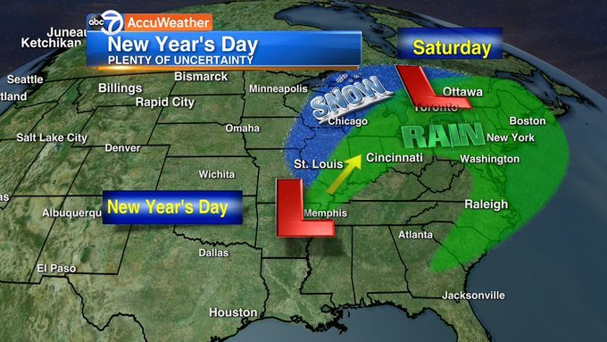
I found my reasoning, Courtesy, Phil Scwarz of ABC in Chicago. definite fun week of watching over the holiday period no matter how it turns out.
-
^deleted it. I need to rise above. apologies to the board for off topic bs in the middle of a great upcoming period.
-
I'll go Cape Girardeau- Indianapolis- Toledo track. Pretty simple.
-
easy toss.
-
Going to be a fun week. And right on cue.


