

Baum
-
Posts
4,523 -
Joined
-
Last visited
Content Type
Profiles
Blogs
Forums
American Weather
Media Demo
Store
Gallery
Everything posted by Baum
-
going to be real interesting how the LOT boys play this.
-
yep. that's why I think you'll see a watch posted across the heart of the LOT metro. But always frustrating when you can't get a consensus on track and intensity.
-
LOT currently
.jpeg.3fa45f47a58776f94dfaf732c964f1ea.jpeg)
-
is this the short term model that showed LOT's NW burbs with a foot 18 hrs out in the last event?
-
was hoping for some movement north to build some confidence in the american solutions. Maybe the euro will bite.
-
you mean reality? While I love to look at 15" kuchera maps IMBY those events don't verify very often. I'll take a 6-12" event and run.
-
if I go 50 degrees and heavy rain to freezing rain/sleet than 5" of snow and a flash freeze that's a pretty substantial event in a 24 hour period. I guess the saving grace it's not followed by a 5 day arctic air mass.
-
snow is a highly emotional game.
-
I like that look.
-
^ I'll let the pro back me up: THE ECMWF CONTINUED, AS NOTED ABOVE, TO HOLD IN ITS "MIDDLE GROUND" SOLUTION, WHILE THE OTHER COMMONLY CITED OPERATIONAL MODELS HELD FARTHER SOUTH (WITH NORTHWARD SHIFTS SINCE 24-HOURS AGO). RC from todays AFD And this is no way throwing full support in the direction of the American models.
-
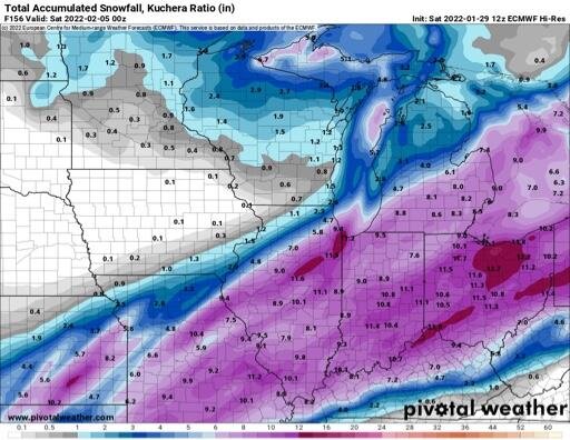
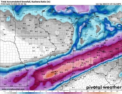
yep on Sunday 1/30 00Z Euro run I was out of the game. Euro worked back to this. As a sidenote, I'll post Canadian Mean. Look familar? Posting old maps as an attempt to show where a compromise on this event is probably in the cards. Note: GFS always had me in a solid event albeit overdone in the end, but still a warning criteria event.
-
I think his call looks good as well. Always easier to take the lower end of guidance in a snow call. But to me, a 3-6" call through the metro already says while the GFS was to far north and wet with the main snow band it didn't have ORD at zero which was the Euro look a day ago. Your own call supports what the non american models showed, and the GEM still shows. Fun to debate, but a read back through the previuos event shows that while the GFS was a touch to north and wet the Euro had to work back north to get LOT center zones in the game.
-
you've been damaged. you need to have faith. Though that out come would be the same as last. And to to say the GFS caved would be false. This time yesterday the Euro basically had the Chicago metro snowless. So in essence it has surrendered a touch to it's American brethren. And again, today is Tuesday. It's a Thursday event.
-
riding the south end of the GFS and the north end of the Euro. And the talk that the euro caved to the gfs,at least on the overunning event last time is not what occurred in NE Illinois. Both models in concert worked towards a consensus. GFS tip toed south and Euro north. But again 72 hours before the event Euro/Gem had me with not a flake while GFS was consistent with 4-8". I ended up with 6". This time every run of the GFS/NAM makes me worry this thing will amp and I'll get a sleet storm but than the Euro gives me hope a compromise/blend puts me in the sweet spot.
-
I don't think 0.6 is too crazy
-
i'm okay with it. golden track for back yard. to bad it's monday night and it's a thursday event.
-
ban
-
Both the NAM and Euro 72 hours or so out showed a complete miss for LOT metro. GFS always had us in the game. EURO ticked NW incrementally and as event neared GFS made a slight shift SE where they reached a consensus track. Probably watching the same scenario again. Weenie in me says were going full on amped this go round. It's time. And I'll save the trouble
-
couldn't have drawn that map better myself.
-
ok.
-
NAM works for me.
-
consensus bust on the Alek call.
-
every dog has his day.

.png.d11ee6d26c58fd807312ceb692a20bc7.png)


.jpeg.c289edb9887248d018c215e579ab31dd.jpeg)