cleetussnow
-
Posts
3,139 -
Joined
-
Last visited
Content Type
Profiles
Blogs
Forums
American Weather
Media Demo
Store
Gallery
Everything posted by cleetussnow
-

It was a Flop... February 2024 Disco. Thread
cleetussnow replied to Prismshine Productions's topic in New England
Storminess on the GFS run. I still feel like punts are the tenor of the season (besides blowtorch and rains to Maines), but I'll reserve judgement for now. -
It was a Flop... February 2024 Disco. Thread
cleetussnow replied to Prismshine Productions's topic in New England
If its not going to snow, let’s be dry at least. The overcast and rain has been getting to people. -
It was a Flop... February 2024 Disco. Thread
cleetussnow replied to Prismshine Productions's topic in New England
-
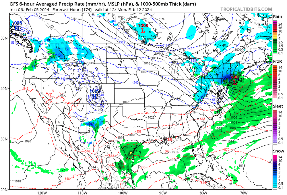
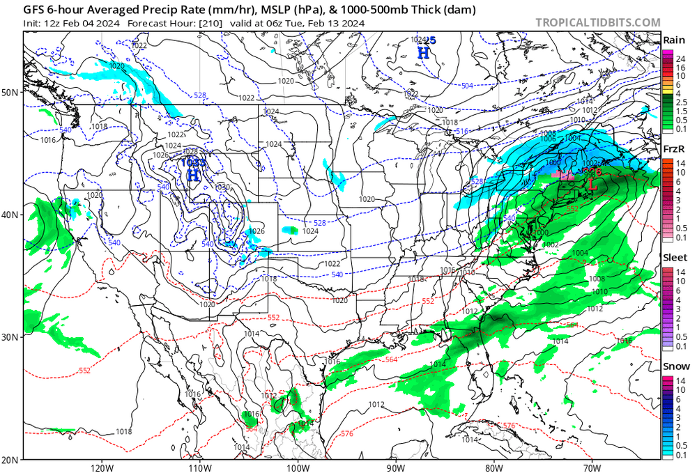
9 days? Is fine to speculate. Thats what we do here…the storm is there, albeit 500 miles south of 12z….so, it IS ‘there’ and thats not meaningless. Its been ‘there’ for a few days. Where is ‘there’ going to be? We can speculate on that, and I say, not where that map puts it.
-
Feb 10 2025
-
Looked good until the last 48 hrs. Rainer. Again, another punt. Let’s get within field goal range with one this winter and try to put up 3.
-
Kind of a shitty flyby if its not coming anywhere near close. And what is this unit of measurement canada geese? Dumshits.
-
It was a Flop... February 2024 Disco. Thread
cleetussnow replied to Prismshine Productions's topic in New England

-
It was a Flop... February 2024 Disco. Thread
cleetussnow replied to Prismshine Productions's topic in New England
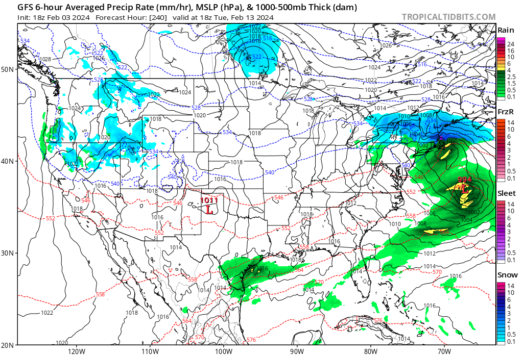
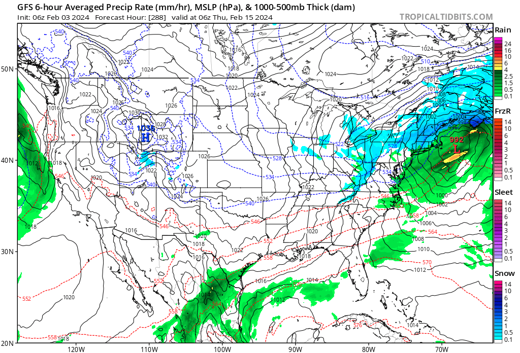
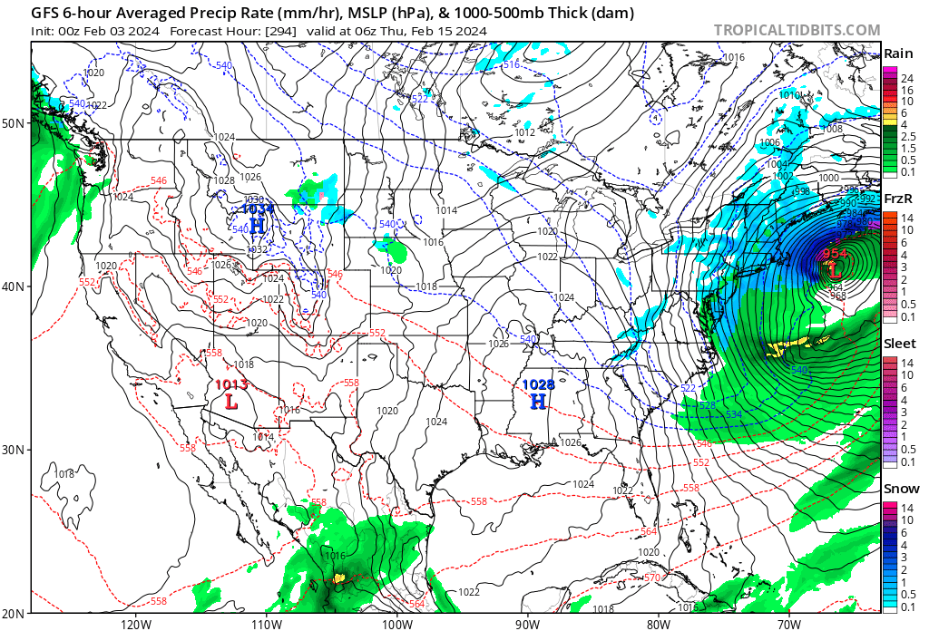
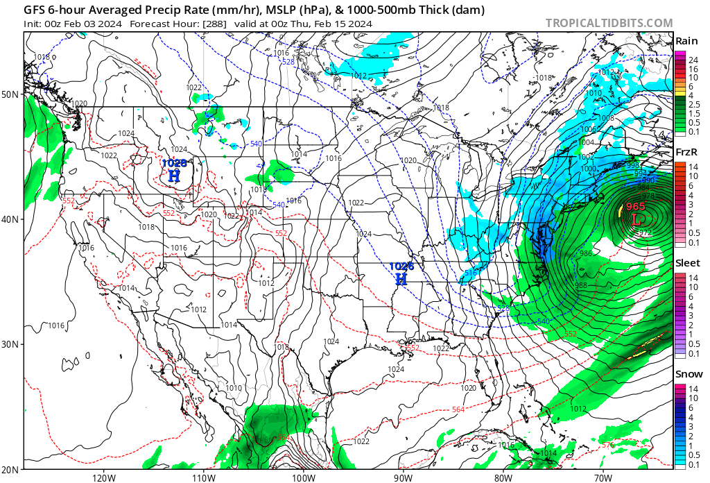
We have seen bombs modeled far out on operational runs come to fruition for sure. Sandy was way out. I’d say 1/2 of the gfs operationals have had some sort of coastal for like 4 days now, and a storm of some variation on the others. Its like the operational has to reflect something distant early warning with red lights flashing, sirens wailing pattern developing across model suites. If it didn’t then its like WTF everywhere. If we are tracking a bomb for 15 days on op runs, thats a thriller to me, and we may be doing just that. Or not - but we’ll be 10 days op Euro today ish so lets’s see if we get a signal. I don’t have the Euro out to 10 myself. Lets hope its not another mirage this time and we can ride this baby in to the BM.
-
It was a Flop... February 2024 Disco. Thread
cleetussnow replied to Prismshine Productions's topic in New England

-
It was a Flop... February 2024 Disco. Thread
cleetussnow replied to Prismshine Productions's topic in New England
Exotic solutions -
It was a Flop... February 2024 Disco. Thread
cleetussnow replied to Prismshine Productions's topic in New England

-
It was a Flop... February 2024 Disco. Thread
cleetussnow replied to Prismshine Productions's topic in New England

-
It was a Flop... February 2024 Disco. Thread
cleetussnow replied to Prismshine Productions's topic in New England
People obviously feel like the coin is loaded - i.e. it flips tails >50% by a lot, so they go with that. They think someone betting heads is wrong or wishcasting despite what models say. That said, I'm leery and already on the ratter train. Hopefully the Brooklynwx train stops at Feb 15th station and we can get on board that for awhile. long way off... -
It was a Flop... February 2024 Disco. Thread
cleetussnow replied to Prismshine Productions's topic in New England
The Euro would be out to the 11th - how's it look? -
It's possible that one biggie can get a lot of stations close to normal and we saw that during the 'snowy epoch' since the mid 90s. 2006 comes to mind where a single storm did that, and that was mid Feb. I haven't looked at the data in awhile but it seems we don't tend to get like six 5-inch storms to get to normal for CPK. Also, we don't normally just land on 'normal;' instead we do something like 15" or 45" and it averages out to normal ~30" over time. And when we get above normal, we get a couple biggies in it. I'm hoping we do get that big storm magic while the pattern is good, but I'm on the record for a ratter. It will still take some luck on timing even in a good pattern. Good patterns can absolutely fail to deliver.
-
It was a Flop... February 2024 Disco. Thread
cleetussnow replied to Prismshine Productions's topic in New England
In case anyone wants to see -
It was a Flop... February 2024 Disco. Thread
cleetussnow replied to Prismshine Productions's topic in New England
-
It was a Flop... February 2024 Disco. Thread
cleetussnow replied to Prismshine Productions's topic in New England
I would love it. I remember the shows with DT raleighwx, marcus, some other people. Lets do this. We can use zoom or hop on discord. -
It was a Flop... February 2024 Disco. Thread
cleetussnow replied to Prismshine Productions's topic in New England
You are a good poster. The other new guy too. You should change your name to Starman. Group? What do you think? -
It was a Flop... February 2024 Disco. Thread
cleetussnow replied to Prismshine Productions's topic in New England
So ‘pandemic’ is the new apocalypse. Got it. -
It was a Flop... February 2024 Disco. Thread
cleetussnow replied to Prismshine Productions's topic in New England
How do you see anything with the black thing on your head? -
It was a Flop... February 2024 Disco. Thread
cleetussnow replied to Prismshine Productions's topic in New England
I deleted it after spending 5 seconds looking back in the thread cuz yeah. -
It was a Flop... February 2024 Disco. Thread
cleetussnow replied to Prismshine Productions's topic in New England
Same! My wife had a secret weather blog she went to after reading my weather reports to compare forecasts. She never trusted mine until Sandy. I had to earn it, I guess. -
I think a lot on here would sign up for a 6-10 region-wide deal in trade for more winter thereafter. Let's get one and we can wrap it up and call it a season.