stormy
-
Posts
1,991 -
Joined
-
Last visited
Content Type
Profiles
Blogs
Forums
American Weather
Media Demo
Store
Gallery
Everything posted by stormy
-
Jan/Early Feb Medium/Long Range Discussion Part 3
stormy replied to WinterWxLuvr's topic in Mid Atlantic
I Love those classic cars buried in snow during early March of 1960............................................. https://winstonsalemtimetraveler.com/2020/03/18/wayback-wednesday-the-snowy-march-1960-wednesdays/ -
Jan/Early Feb Medium/Long Range Discussion Part 3
stormy replied to WinterWxLuvr's topic in Mid Atlantic
Thanks!! I was just ready to try again with the link. -
Jan/Early Feb Medium/Long Range Discussion Part 3
stormy replied to WinterWxLuvr's topic in Mid Atlantic
A lot of high anticipation is quite obvious this afternoon. Will mid February to mid March thrill snow lovers in the tristate region or will it end in disappointment???? We cannot know at this time. Ask me around April 1. Psu has often referred to 1958 Feb/March. The advertised possibilities are now reminding me of 1960. During mid Feb - mid March of 1960, brutal cold and repetitive snowstorms nearly paralyzed the western Carolina's and Virginia. While your dreaming about the possibilities, read the details of 1960 from Laurence Lee of NOAA: file:///C:/Users/James/Downloads/Review_Feb-Mar_1960(1).pdf -
Jan/Early Feb Medium/Long Range Discussion Part 3
stormy replied to WinterWxLuvr's topic in Mid Atlantic
I'm with you man!! We all have regrets looking back over our lives. -
Jan/Early Feb Medium/Long Range Discussion Part 3
stormy replied to WinterWxLuvr's topic in Mid Atlantic
You just haven't lived quite long enough! -
Jan/Early Feb Medium/Long Range Discussion Part 3
stormy replied to WinterWxLuvr's topic in Mid Atlantic
Ice is trending in your direction. Perhaps a half inch of ice in southwest Va. -
Jan/Early Feb Medium/Long Range Discussion Part 3
stormy replied to WinterWxLuvr's topic in Mid Atlantic
If the GFS 24 hr. trend continues the 12z run will have precipitation up into central Virginia. Surface and 850 temps. would be borderline. -
Jan/Early Feb Medium/Long Range Discussion Part 3
stormy replied to WinterWxLuvr's topic in Mid Atlantic
Thanks Bob for your usual bundle of wisdom. -
Jan/Early Feb Medium/Long Range Discussion Part 3
stormy replied to WinterWxLuvr's topic in Mid Atlantic
Honestly, I had this feeling 24 hrs. ago. after I looked at the latest Weeklies. I tracked the trajectory of the lowest heights and got an uneasy feeling. I still have high hopes but not as confident as 5 days ago. -
January 31st Clipper. Will we get clipped or chumped?
stormy replied to clskinsfan's topic in Mid Atlantic
You say that you ignore me because I don't make contributions. A lot of posters don't really make contributions. Do you believe that making blatantly incorrect posts is making a contribution?? You said the 18z NAM " was " better this run". Considering the significant down grade on WB I find it unlikely that Pivotol was better unless you want less snow!! Anyone can make a mistake, I believe you made one and don't have the courage to admit it. All you can do is attack others. That is very disappointing. -
January 31st Clipper. Will we get clipped or chumped?
stormy replied to clskinsfan's topic in Mid Atlantic

-
January 31st Clipper. Will we get clipped or chumped?
stormy replied to clskinsfan's topic in Mid Atlantic
You say the NAM was "better this run" What am I missing?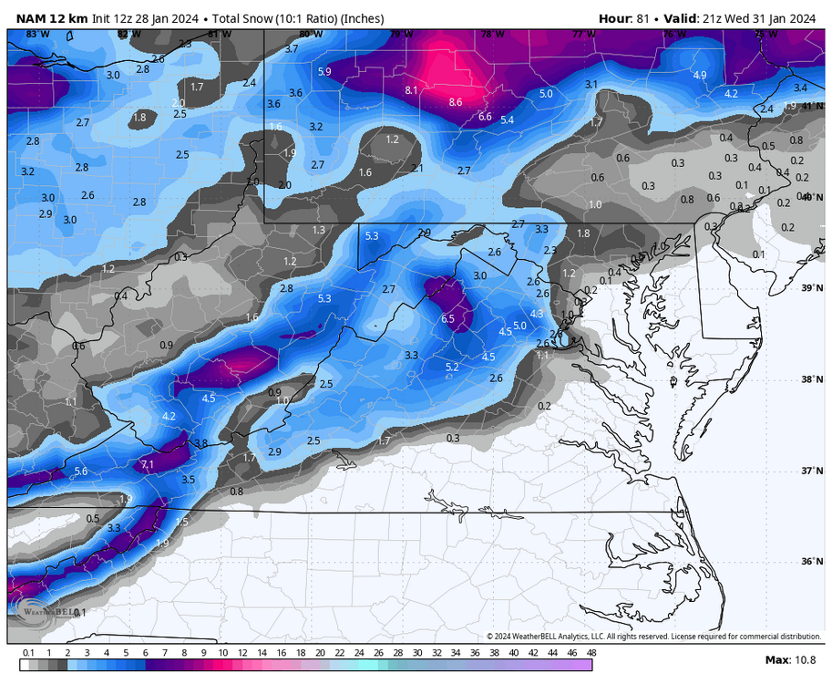
-
January 31st Clipper. Will we get clipped or chumped?
stormy replied to clskinsfan's topic in Mid Atlantic
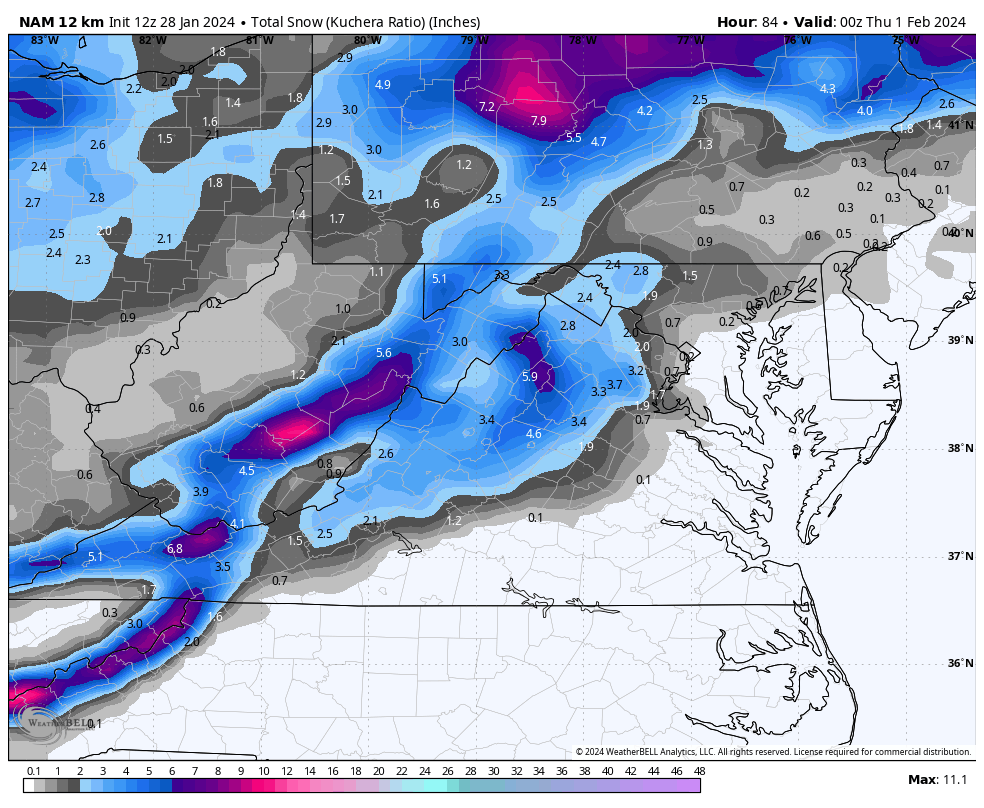
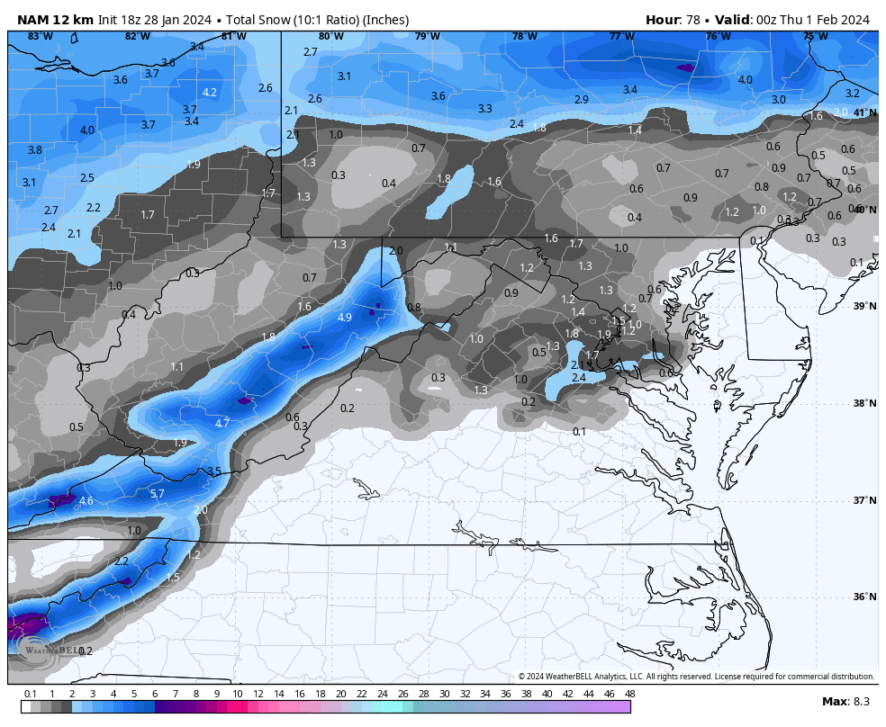
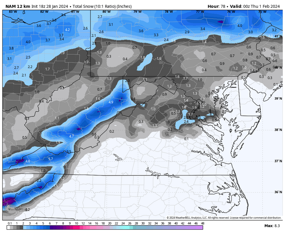
This potential will affect areas along and west of the Blue Ridge, focusing on the central and southern Valley and western highlands. Tuesday night: Mostly cloudy with a 60% likelihood of snow showers after midnight. Lows of 31 - 33 Wednesday: Early snow showers tapering off, remaining mostly cloudy with highs of 35 - 40. Accumulations of a dusting to 1 inch below 2000 ft. elevation. Accumulations of 1 -3 inches, 2500 - 4500 ft. elevation. -
Jan/Early Feb Medium/Long Range Discussion Part 3
stormy replied to WinterWxLuvr's topic in Mid Atlantic
Good Luck Cape! The 18z GFS says southern suppression but there is a plenty of time! -
Jan/Early Feb Medium/Long Range Discussion Part 3
stormy replied to WinterWxLuvr's topic in Mid Atlantic
Which one of the 5 in the Atlantic on that map are you speaking of?? -
Jan/Early Feb Medium/Long Range Discussion Part 3
stormy replied to WinterWxLuvr's topic in Mid Atlantic
I'll take p 22 -
Jan/Early Feb Medium/Long Range Discussion Part 3
stormy replied to WinterWxLuvr's topic in Mid Atlantic
The Euro just won't give up on 2-5 !!!!!!! 7 inches at Norfolk .......... On to 00z. -
Jan/Early Feb Medium/Long Range Discussion Part 3
stormy replied to WinterWxLuvr's topic in Mid Atlantic
This is beyond 6z. The Euro is interested. -
Jan/Early Feb Medium/Long Range Discussion Part 3
stormy replied to WinterWxLuvr's topic in Mid Atlantic
The 12z GFS and now on board GEM gives Augusta 1.5 - 3.0 inches from this system at 96 - 120 Upstairs temps. look good but likely an elevation event unless we chill a few degrees. -
Jan/Early Feb Medium/Long Range Discussion Part 3
stormy replied to WinterWxLuvr's topic in Mid Atlantic
That's a miss to the south -
Jan/Early Feb Medium/Long Range Discussion Part 3
stormy replied to WinterWxLuvr's topic in Mid Atlantic
Things are looking a lot better, but parts of the Valley are still abnormally dry. My water table is still 10.68 ft. below normal according to the USGS. -
Jan/Early Feb Medium/Long Range Discussion Part 3
stormy replied to WinterWxLuvr's topic in Mid Atlantic
DT's PA Pattern died with the issuance of the 00z GFS. -
Jan/Early Feb Medium/Long Range Discussion Part 3
stormy replied to WinterWxLuvr's topic in Mid Atlantic
This was my post late yesterday after being surprised by the 18z GFS op for a few minutes. I then realized with these words that the 18z was likely trash that would not stand the test of time. I didn't call it trash at the time for obvious reasons considering the euphoria. 240+ hours is almost always fantasy land for the GFS op. The EPS still looks fine for Feb. 12 - March 12. -
Jan/Early Feb Medium/Long Range Discussion Part 3
stormy replied to WinterWxLuvr's topic in Mid Atlantic
Are we seeing something here that should not be happening?? -
Jan/Early Feb Medium/Long Range Discussion Part 3
stormy replied to WinterWxLuvr's topic in Mid Atlantic
That's the only way to go!!!!!