stormy
-
Posts
2,104 -
Joined
-
Last visited
Content Type
Profiles
Blogs
Forums
American Weather
Media Demo
Store
Gallery
Everything posted by stormy
-
January 31st Clipper. Will we get clipped or chumped?
stormy replied to clskinsfan's topic in Mid Atlantic
This potential will affect areas along and west of the Blue Ridge, focusing on the central and southern Valley and western highlands. Tuesday night: Mostly cloudy with a 60% likelihood of snow showers after midnight. Lows of 31 - 33 Wednesday: Early snow showers tapering off, remaining mostly cloudy with highs of 35 - 40. Accumulations of a dusting to 1 inch below 2000 ft. elevation. Accumulations of 1 -3 inches, 2500 - 4500 ft. elevation. -
Jan/Early Feb Medium/Long Range Discussion Part 3
stormy replied to WinterWxLuvr's topic in Mid Atlantic
Good Luck Cape! The 18z GFS says southern suppression but there is a plenty of time! -
Jan/Early Feb Medium/Long Range Discussion Part 3
stormy replied to WinterWxLuvr's topic in Mid Atlantic
Which one of the 5 in the Atlantic on that map are you speaking of?? -
Jan/Early Feb Medium/Long Range Discussion Part 3
stormy replied to WinterWxLuvr's topic in Mid Atlantic
I'll take p 22 -
Jan/Early Feb Medium/Long Range Discussion Part 3
stormy replied to WinterWxLuvr's topic in Mid Atlantic
The Euro just won't give up on 2-5 !!!!!!! 7 inches at Norfolk .......... On to 00z. -
Jan/Early Feb Medium/Long Range Discussion Part 3
stormy replied to WinterWxLuvr's topic in Mid Atlantic
This is beyond 6z. The Euro is interested. -
Jan/Early Feb Medium/Long Range Discussion Part 3
stormy replied to WinterWxLuvr's topic in Mid Atlantic
The 12z GFS and now on board GEM gives Augusta 1.5 - 3.0 inches from this system at 96 - 120 Upstairs temps. look good but likely an elevation event unless we chill a few degrees. -
Jan/Early Feb Medium/Long Range Discussion Part 3
stormy replied to WinterWxLuvr's topic in Mid Atlantic
That's a miss to the south -
Jan/Early Feb Medium/Long Range Discussion Part 3
stormy replied to WinterWxLuvr's topic in Mid Atlantic
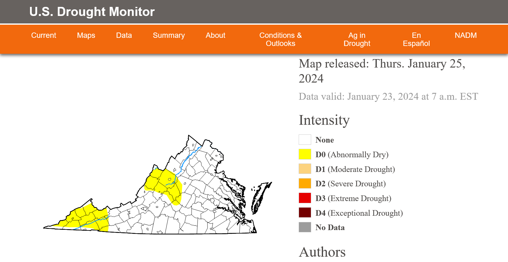
Things are looking a lot better, but parts of the Valley are still abnormally dry. My water table is still 10.68 ft. below normal according to the USGS. -
Jan/Early Feb Medium/Long Range Discussion Part 3
stormy replied to WinterWxLuvr's topic in Mid Atlantic
DT's PA Pattern died with the issuance of the 00z GFS. -
Jan/Early Feb Medium/Long Range Discussion Part 3
stormy replied to WinterWxLuvr's topic in Mid Atlantic
This was my post late yesterday after being surprised by the 18z GFS op for a few minutes. I then realized with these words that the 18z was likely trash that would not stand the test of time. I didn't call it trash at the time for obvious reasons considering the euphoria. 240+ hours is almost always fantasy land for the GFS op. The EPS still looks fine for Feb. 12 - March 12. -
Jan/Early Feb Medium/Long Range Discussion Part 3
stormy replied to WinterWxLuvr's topic in Mid Atlantic
Are we seeing something here that should not be happening?? -
Jan/Early Feb Medium/Long Range Discussion Part 3
stormy replied to WinterWxLuvr's topic in Mid Atlantic
That's the only way to go!!!!! -
Jan/Early Feb Medium/Long Range Discussion Part 3
stormy replied to WinterWxLuvr's topic in Mid Atlantic
Mid January to mid March has always been the sweetspot back to 1958. I remember 1958 well because it was the first time anyone could remember Rt. 11 (The Valley Pike) being closed by drifting snow north of Harrisonburg. This was before I-81 had ever been heard of, 11 was the main north/south thoroughfare. Will we revisit 1958 this year ? -
The update this morning puts the ground water in better shape than in a long, long time though still abnormally dry over Augusta County.
-
Most of my snow has melted except drifts and pushed up mounds. 54 degrees and .02" rain last night.
-
The snowpack in those mountains around you kept you in the refrigerator.
-
Jan/Early Feb Medium/Long Range Discussion Part 3
stormy replied to WinterWxLuvr's topic in Mid Atlantic
Heaven forbid!! On this day in 1967 it was 72 degrees at Staunton! The 06z GFS op. gives Boone N.C. 26 inches of snow during early Feb...... The EPS will save us! -
Jan/Early Feb Medium/Long Range Discussion Part 3
stormy replied to WinterWxLuvr's topic in Mid Atlantic
Late Sunday and Sunday night could be interesting according to the 18z GFS. Some of the blue has been pushed south and southwest. -
Jan/Early Feb Medium/Long Range Discussion Part 3
stormy replied to WinterWxLuvr's topic in Mid Atlantic
When I began looking at his thread early last Saturday morning, the "experts" were arguing about Pacific Jet Extensions. Somewhat bored with that crap I began perusing the models and ensembles. I discovered a very enticing look on the Euro Ensembles for mid February into March. Somewhat surprised that nobody was talking about it I posted a comment at 9:22 am. The rest is history. That enticing look has persisted and now we are up to March 10. -
Jan/Early Feb Medium/Long Range Discussion Part 3
stormy replied to WinterWxLuvr's topic in Mid Atlantic
Thanks for your input. The 90+ days 75 years ago are 2 - 1 more than recent years. Pre 1958 which is the 50% benchmark there were 17 90 degree + days. Post 1958 there were 7 90+ days on August 1. -
Jan/Early Feb Medium/Long Range Discussion Part 3
stormy replied to WinterWxLuvr's topic in Mid Atlantic
Thanks!! This is quite interesting, no trend since 1893. The luck of the draw with various winter patterns! My records at Staunton go back to 1893. The Staunton records clearly reveal that summers were hotter 100 years ago. More 90+ days pre 1958 than post 1958. I closely tracked this during last summer for my newsletter. -
Jan/Early Feb Medium/Long Range Discussion Part 3
stormy replied to WinterWxLuvr's topic in Mid Atlantic
We seem to be experiencing a dose of reality this morning as we talk about winter weather patterns. Some seem to remember the 60's as the coldest/snowiest decade in the last 100 years and lament recent years as if we now live in a semi tropical climate. I lived through the 60's, I have good memories and good records. Sure, the 60's had many cold patterns during winter and several heavy snowfall winters. I remember ice skating on area rivers and snow sledding when it seemed snow was always on the ground. Honestly, my recall of the 60's focuses on the very cold snowy times. But guess what, as Terpeast said, we always seem to remember the cold snowy times and forget about the other warm, rainy times. March 5 - 7 in 1962, the Shenandoah Valley received 24 - 36 inches of snow during the Great Ash Wednesday Storm............................ Guess what the month preceding that storm was like? Feb. 4 of 62 at Staunton was very mild at 64 degrees, Feb. 5 of 62 saw 70 degrees, Feb. 6 very mild with 66 degrees, Feb 23 of 62 nice at 66 degrees, Feb. 28 had 68 degrees. February of 1962 gave Staunton 2.39" of rain and no snow. March 1 of 1962 found folks saying spring is here at 70 degrees !!!! 5 - 6 days later we received 2 - 3 feet of snow!!! March 9-10 produced another 5 inches of snow. -
Jan/Early Feb Medium/Long Range Discussion Part 3
stormy replied to WinterWxLuvr's topic in Mid Atlantic
The 18 z GFS is catching up with the ECM Weeklies..................................................................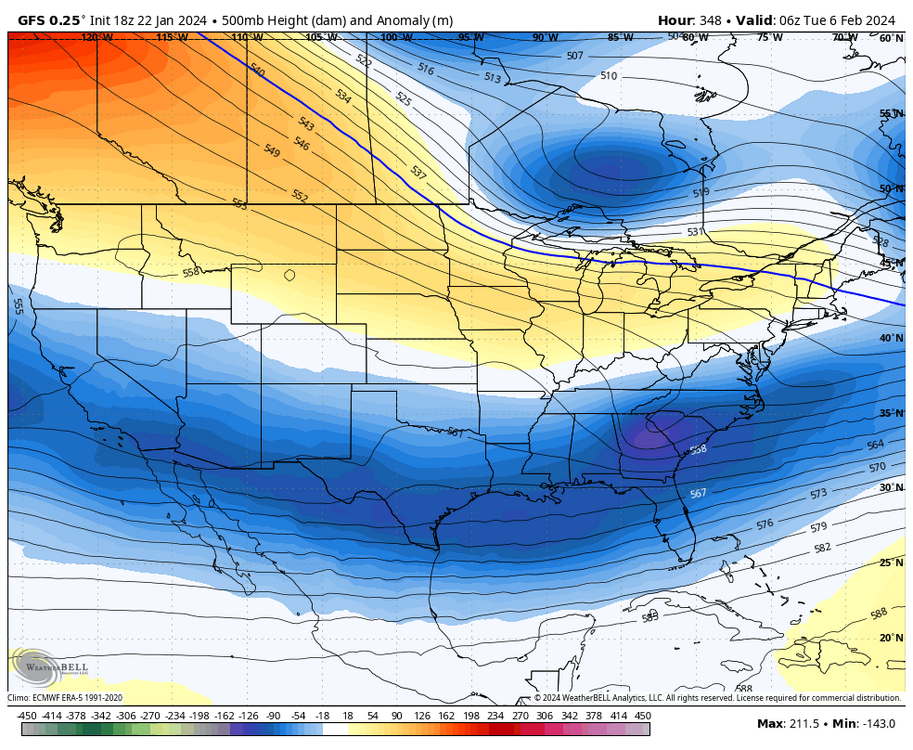
-
4.6 this morning