stormy
-
Posts
2,104 -
Joined
-
Last visited
Content Type
Profiles
Blogs
Forums
American Weather
Media Demo
Store
Gallery
Everything posted by stormy
-
Jan/Early Feb Medium/Long Range Discussion Part 3
stormy replied to WinterWxLuvr's topic in Mid Atlantic
If the projected pattern repeats for the next week, probability of verification certainly increases. -
Jan/Early Feb Medium/Long Range Discussion Part 3
stormy replied to WinterWxLuvr's topic in Mid Atlantic
Since I posted the good look on the Euro Weeklies at 9:22 Saturday morning, others have became interested and no experts have pooh-poohed the synoptics. With the new run today, no real changes. Anytime after Feb. 10 - March 10 should bring good times for snow-lovers if verification is realized. -
15 degrees at 6 pm. Headed to Zero tonight.
-
Jan/Early Feb Medium/Long Range Discussion Part 3
stormy replied to WinterWxLuvr's topic in Mid Atlantic
The stream that flows through my property was higher during this Jan. 96 flood than elderly people could remember ever before. -
Jan/Early Feb Medium/Long Range Discussion Part 3
stormy replied to WinterWxLuvr's topic in Mid Atlantic
I remember it well. 30 inches of snow followed by 3.20 inches of rain a week later. Almost unbelievable!!!!!!! -
Jan/Early Feb Medium/Long Range Discussion Part 3
stormy replied to WinterWxLuvr's topic in Mid Atlantic
My friend, the chances of serious flooding during the next 15 days is minimal. Snowpack melt is negligible as less than an inch of qp is in most snowpack. WPC 7 day qpf is 1.0 - 1.5 inches. This timeframe will completely eliminate snowpack. Have no fear of serious flooding unless guidance changes significantly. -
Jan/Early Feb Medium/Long Range Discussion Part 3
stormy replied to WinterWxLuvr's topic in Mid Atlantic
I'm at 1300 ft. though there are 1550' elevations no more than a mile away. I'm looking at 3000 ft. elevations in the Blue Ridge about 4 miles to my east. -
Jan/Early Feb Medium/Long Range Discussion Part 3
stormy replied to WinterWxLuvr's topic in Mid Atlantic
March has been a big winter month in my region going back to 1960. 1962 put the icing on the cake. For anyone suffering amnesia, 1993 reminded. -
Jan/Early Feb Medium/Long Range Discussion Part 3
stormy replied to WinterWxLuvr's topic in Mid Atlantic
Nothing but noise -
Jan/Early Feb Medium/Long Range Discussion Part 3
stormy replied to WinterWxLuvr's topic in Mid Atlantic
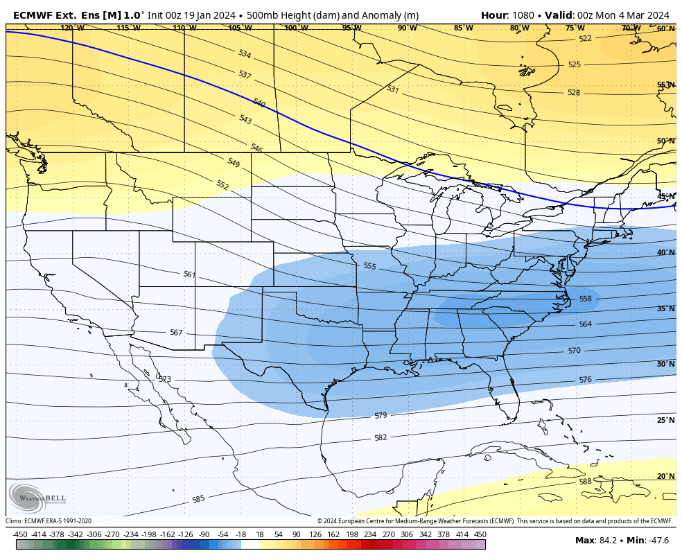
The GFS is doing its normal run to run disco from Jan. 30 - Feb 5. Regarding a possible late winter pattern, the Euro Weeklies more or less paint a January thaw beginning early week and extending thru Feb 5. Could be mild and wet. A developing plus PNA encourages eastern troughiness and lower heights from Feb. 15 - March 5. If that verifies, late Feb. into March could be quite interesting. Experts, please tell me why this wouldn't work.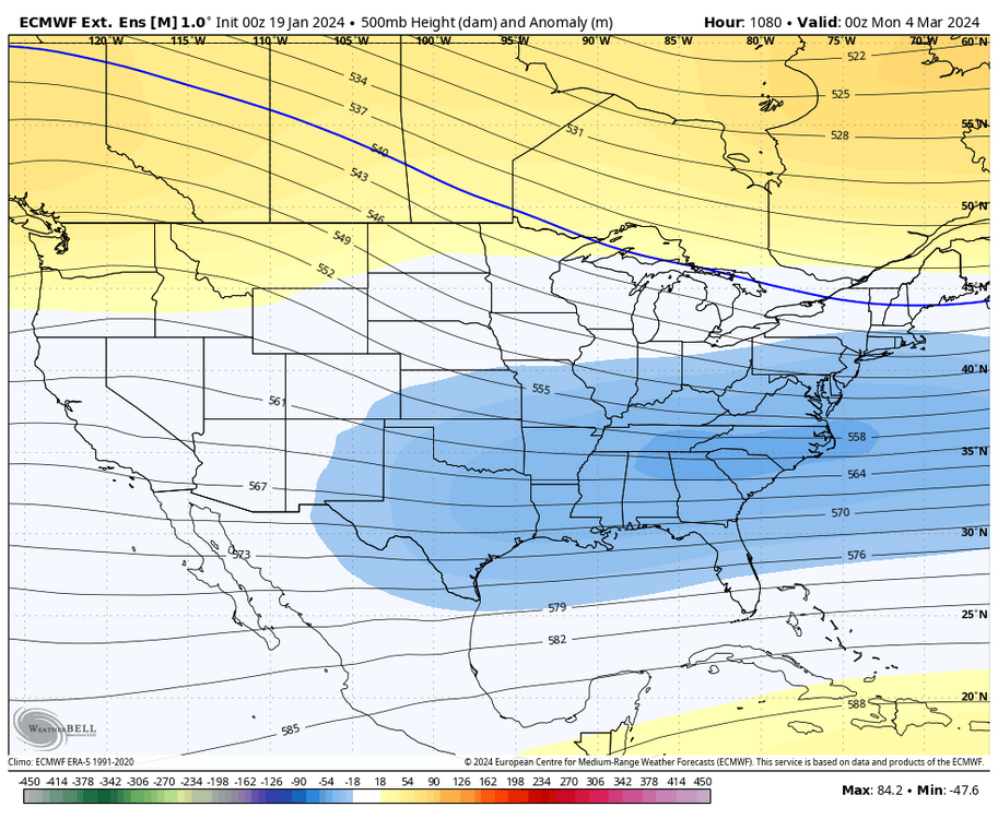
-
Only .70" snow in Augusta. The GFS, ECM, GEM and NAM were all wrong 24 hrs. ago about the southward suppression of the snow at nearly 2.00 inches for Augusta. The ICON was the closest to correct model at .90".
-
The Shenandoah is truly God's World! Just don't tell anyone!!!!!!
-
My Augusta 4 model blend with the 12z GEM, 18z GFS, ECM and NAM increases from 1.3" to 1.9". Kuchera increases from 1.7 to 2.4" 18z NAM 12 k spiked from 1.2 to 2.5" and the 3k Nest jumped from 1.1 to 2.8" . NWS says WWA with 1-2, how about 1-3????
-
Jan 19th Snow on Snow: the this always works until it doesn't thread
stormy replied to psuhoffman's topic in Mid Atlantic
I did not include the ICON in the blend. -
Jan 19th Snow on Snow: the this always works until it doesn't thread
stormy replied to psuhoffman's topic in Mid Atlantic
Out here in Augusta County my 4 model blend has increased from .5" last night to 1.3" with the 12z runs. 1.7" Kuchera. A definite shift south on the GFS, ECM, GEM, NAM and ICON. -
One piece of Trivia that some may be interested in. Knoxville, Tenn. received 9.5 inches of snow Tuesday. According to the NWS, their average annual snowfall is 4.6 inches. Doubled that in one storm!!
-
Jan/Early Feb Medium/Long Range Discussion Part 3
stormy replied to WinterWxLuvr's topic in Mid Atlantic
Historically, Nino winters are not wet, wall to wall. We have been wet for 60 days. This is likely a time-out. I predict a wild and woolly period from Feb 1 - March 25. This would mimic 1958 which psu refers to. Mid Feb. thru Mid March of 1958 was historically brutal, breaking many snowfall records across Virginia/Maryland. We may do it again.... -
Jan 18-19 Storm Threat: Bob Chill made me do it
stormy replied to stormtracker's topic in Mid Atlantic
What more could anyone say. My blend has dropped from 2.0 to .5 in 24 hrs.. Here comes the drought! -
Jan 18-19 Storm Threat: Bob Chill made me do it
stormy replied to stormtracker's topic in Mid Atlantic
My 4 model blend for Augusta dropped from 2.0 to 1.4 overnight. -
Overnight low of +3 at 12:30. 8 at 7:30 with an 11 mph wind.
-
Jan 18-19 Storm Threat: Bob Chill made me do it
stormy replied to stormtracker's topic in Mid Atlantic
My 4 model blend is up to 2.00" for late Thursday night/Friday for Augusta County. -
Jan 18-19 Storm Threat: Bob Chill made me do it
stormy replied to stormtracker's topic in Mid Atlantic
Be careful -
Total of 4.25". I'm happy because my prediction in my newsletter Monday morning was 3 - 6". The models did quite well 30 hrs. pre-event at 9 pm Sunday, ranging from 3.0" ECM, 4.0" GFS to 4.7 GEM The winner Monday 6 am was the GFS at 4.2 10:1.
-
As psu said yesterday, do you want the truth or do you want bs. It's outa here by 2 am.
-
2- 4 inches tapering off after midnight. The earlier guidance has been sustained by the 18z GFS.