stormy
-
Posts
2,104 -
Joined
-
Last visited
Content Type
Profiles
Blogs
Forums
American Weather
Media Demo
Store
Gallery
Everything posted by stormy
-
A southern slider always works on April 26!!! Somebody, start a thread!!!!!!!!
-
A few miles to your northwest I only received .67. Whetstone Ridge up on the Parkway near Montebello at 3023 ft. reported 4.30"!!!!
-
Convection along the southeast coast is robbing lift potential over Virginia. Robust dynamics to our west may be able to overcome.
-
April 8th Eclipse- Last Easy One To See In My Lifetime
stormy replied to Interstate's topic in Mid Atlantic
89.4% at 3:17. A total failure because a heavy stratus deck moved in around 3. The weak radiation at 11% couldn't burn through the clouds. Now back to 15% and the sun is returning but too late! -
24.2 degrees this morning froze all blooming peaches, cherries and plums in my orchard.
-
Snowshoe has received 5 - 8 inches with mod/ heavy snow falling and 26 degrees.
-
LOL ........ LOL
-
In 2004 the opening pitch was at 40 degrees!!!!!
-
Its beginning to snow at Spruce Knob at 34F. 6 - 12" can fall at these heights above 3500 ft during the next 48 hrs..
-
.63" last night and this morning. Finally a decent rain!!!
-
24 hours ago, the 171 input suite of the NOAA NBM predicted that central Augusta would receive an average of .70" of qp by 12z today. I have received .08".
-
That would be earth shattering! I'll look into it. A 10 year run of 90% accuracy is phenomenal.
-
2.54 " March total rainfall. This is only 72% of normal. A rather remarkable statistic: 8 of the past 8 Marches have been drier than normal in my area. 100% dry in March during the past 8 years!! 7 of the past 8 winters have had below normal snowfall. 87% of the time during the past 8 years, low winter snowfall precedes a dry March west of the Blue Ridge. The last wet March was 2015. During the winter of 14/15 I had above normal snowfall. Before that, March of 2014 was wet. I also had above normal snowfall for the 13/14 winter!!!!!!!!!!!!
-
The pattern in late week would not benefit us whether it was Jan. or April. Up-slope snow does not affect areas east of the mts.. We are in a down-slope region.
-
.17" rain on Wednesday. 2.38" so far in March vs a normal of 3.51". I will plan to post tomorrow or Monday about dry Marches in my region related to previous winter snowfall. A 3 model blend gives the higher elevations of W.Va. between Elkins and Snowshoe 9. 7 inches of snow between Wednesday and late Friday.
-
22 early this morning. 11 years ago this morning was a winter wonderland at my place! 6.5 inches of snow and 28 degrees. 3.5 inches fell on Palm Sunday afternoon and 3 more inches Sunday night. Mar. 25, 2013.
-
The squirrels are shivering this morning at 22 degrees!
-
.83" total. As I suspected yesterday afternoon the Icon was out to lunch with only .53". The GFS nailed it at .82" I have discovered an astonishing relationship between March rainfall and previous winter snowfall during the past 8 years. More on this when March welcomes April.
-
I must believe the 18z ICON is out to lunch because I see greater lift potential to the west of 95.
-
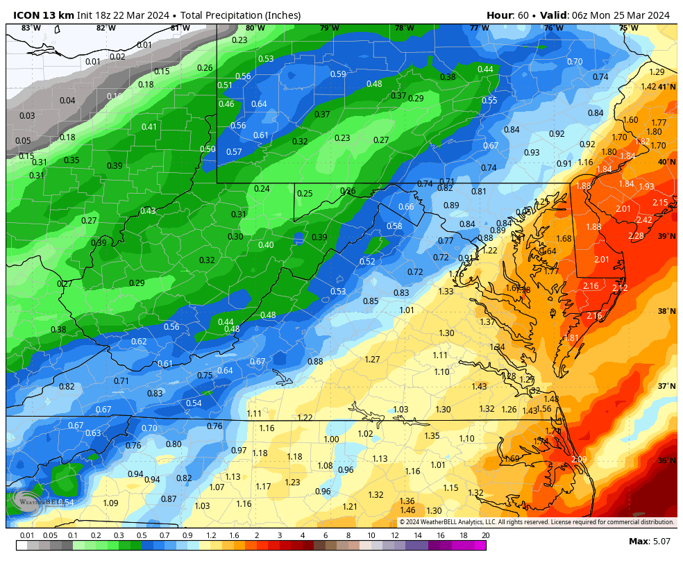
The 18z ICON pushes the heavy swath of rain to coastal areas.........................................................

-
Unfortunately, I must agree! The heaviest swath is shifting east. We will know by 00z Sunday.
-
According to the 18z NAM 3 and 12, the heaviest swath of rain will run up east of the Blue Ridge toward 95.
-
March has been very dry across the Central Valley. I have received a total of 1.38" compared to a normal on March 21 of 2.31". This is only 60% of normal rainfall. This reality has resulted in a rash of wildfires aggravated by high winds.
-
22 at 7 am. A soaking rain will really help with the very dry conditions, smoke and wildfires. A 5 model blend gives D.C. 1.65" and Augusta 1.02". All important Luray receives 1.23".
-
Your intelligence is bold face. The other Clowns are to be discounted.