stormy
Members-
Posts
2,009 -
Joined
-
Last visited
Content Type
Profiles
Blogs
Forums
American Weather
Media Demo
Store
Gallery
Everything posted by stormy
-
2024 Valentines Day Who the Hell Knows - Comeback Thread
stormy replied to DDweatherman's topic in Mid Atlantic
Short Pump -
Foolishness will have to be taken up with the scientists who conducted this study because they are saying that an abrupt interruption of natural cycles very similar to the Younger Dryas may be coming soon. It could have devastating impact around the world. When you say that the level of impact that humans can have on the climate is limited, I believe You and I could be friends. Enjoy the Super Bowl.
- 2,509 replies
-
- 1
-

-
- weenie fest or weenie roast?
- weenies got roasted
- (and 2 more)
-
I will be brief with an answer before deferring to the C.C. Thread. You obviously misunderstand the premise. This study suggests that the Glacial-interglacial cycles are not germane anymore because of our CO2 transgressions. The climate gurus at the U.N. said 5 years ago that it would be more than 300 years before the AMOC shuts down. Now, many scientists are saying with the AMOC at its weakest in 1,600 years, it could shut down completely between 2025 and 2095.
- 2,509 replies
-
- weenie fest or weenie roast?
- weenies got roasted
- (and 2 more)
-
- 2,509 replies
-
- 2
-

-
- weenie fest or weenie roast?
- weenies got roasted
- (and 2 more)
-
GEFS a little more generous with rain thru Tuesday than op.. 1.40 vs. 1.00" JB will enjoy his 8 inches of snow.
-
12z op. Euro is a PD hit for the Central Valley with 6 - 7 inches of snow. 90% probability it will be gone at 00z, but nice to see.
- 2,509 replies
-
- weenie fest or weenie roast?
- weenies got roasted
- (and 2 more)
-
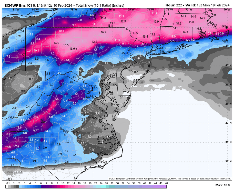
GEFS is suppression city with PD, Weeklies give some possibility of northward translation. Both GEFS and Weeklies give a reasonable threat for 23 & 24.
- 2,509 replies
-
- weenie fest or weenie roast?
- weenies got roasted
- (and 2 more)
-
It will all sort out and settle down by about March 20.
- 2,509 replies
-
- 1
-

-
- weenie fest or weenie roast?
- weenies got roasted
- (and 2 more)
-
It's a mixed bag beyond the range of the ECM and GEM. The 06Z GFS is a huge winner giving me 19 inches!!!!!!!
- 2,509 replies
-
- weenie fest or weenie roast?
- weenies got roasted
- (and 2 more)
-
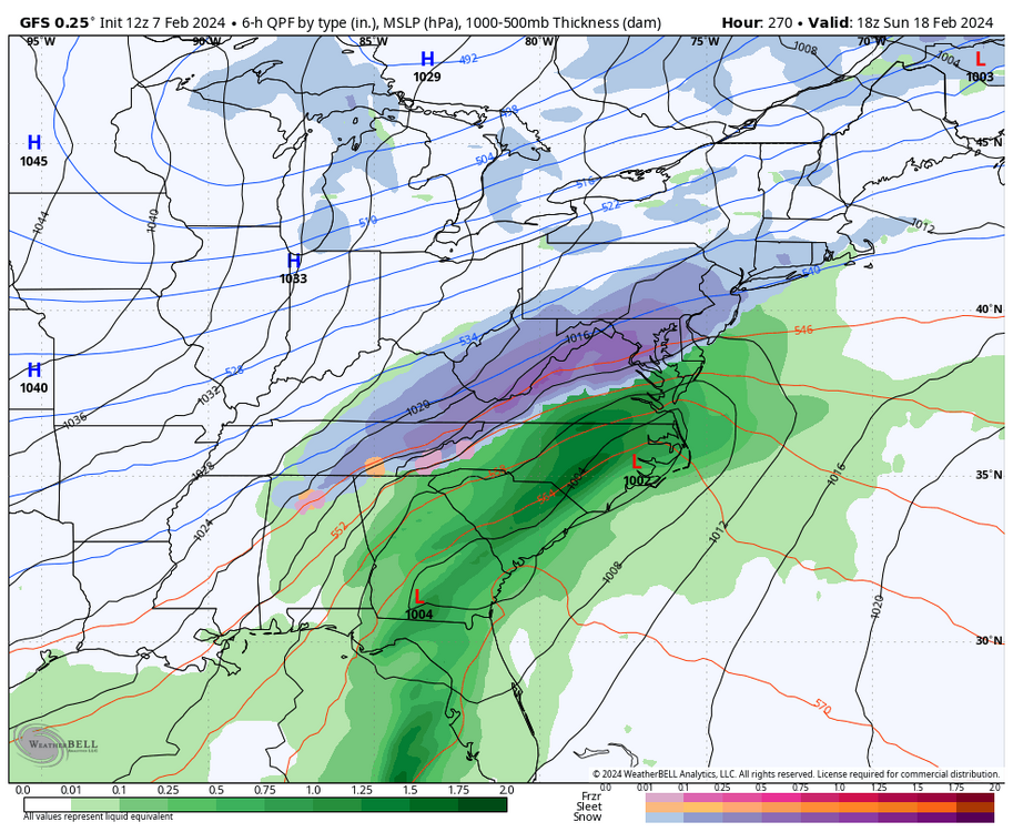
I hear ya! The 240 big 3 were close in the NW Gulf at 12z and the extended GFS op produced with support from the GEFS. The 18 GFS has went to crap in the OV. The Weeklies still look good Feb 21 - Mar. 20 and the potentially suppressive block has diminished.
- 2,509 replies
-
- weenie fest or weenie roast?
- weenies got roasted
- (and 2 more)
-
You could be in the dough with that bet.
- 2,509 replies
-
- weenie fest or weenie roast?
- weenies got roasted
- (and 2 more)
-
Yea man! I have even seen radar fail because the scan is about 12,000 ft. over Augusta. Radar has indicated snow for hours that all evaporated before reaching the surface. That virga can be a beast out here!
- 2,509 replies
-
- 1
-

-
- weenie fest or weenie roast?
- weenies got roasted
- (and 2 more)
-
I'll take this at 270. 3 consecutive runs. At 240 the GFS, ECM and GEM all have the goods brewing in the NW Gulf and S. Texas. It's a SLAM DUNK with all 3 on board at 240. Rather unusual.
- 2,509 replies
-
- 1
-

-
- weenie fest or weenie roast?
- weenies got roasted
- (and 2 more)
-
15.7 degrees this morning. Thats 10 degrees colder than normal!! Regarding the lack of snow at Blackwater Falls, I remember visiting the summit of Spruce Knob at 4862 ft. during the winter back during the early 70's. It was 8 below zero at the summit at mid afternoon. There was not a trace of snow anywhere!! That was 50 years ago. It sometimes happens that way.
-
The big difference between now and 50 years ago is that 50 years we didn't have a clue to what your saying. Nobody did. We only knew that sometimes in winter it snowed and sometimes a lot. Other times, folks generally said, hey! we're lucky to have an easy winter this year.
- 2,509 replies
-
- weenie fest or weenie roast?
- weenies got roasted
- (and 2 more)
-
18z GFS pulls much more cold air upstairs at 850mb into the system on Monday. Makes a big difference.
- 2,509 replies
-
- weenie fest or weenie roast?
- weenies got roasted
- (and 2 more)
-
925 is marginal upfront, 850 will work for most.
- 2,509 replies
-
- weenie fest or weenie roast?
- weenies got roasted
- (and 2 more)
-
Look again on the 18z GFS
- 2,509 replies
-
- weenie fest or weenie roast?
- weenies got roasted
- (and 2 more)
-
13/14 comes to life on 18z GFS
- 2,509 replies
-
- 2
-

-
- weenie fest or weenie roast?
- weenies got roasted
- (and 2 more)
-
The CPC believes we will be close to -.75 C. come October.
- 2,509 replies
-
- weenie fest or weenie roast?
- weenies got roasted
- (and 2 more)
-
Exactly right, Nina's don't all suck for snow. 21-22 was a -1.0 Nina. I received 29 inches of snow.
- 2,509 replies
-
- 1
-

-
- weenie fest or weenie roast?
- weenies got roasted
- (and 2 more)
-
43% of Nino winters since 1980 have given me below normal snowfall. I would be happy to reach climo considering that stat..
- 2,509 replies
-
- weenie fest or weenie roast?
- weenies got roasted
- (and 2 more)
-
Saturday afternoon I predicted that southern suppression would probably be a problem going forward through February because of NS strength. Other factors can also contribute to a generally dryer than normal precipitation pattern. This morning the EPS, CMC and GEFS all support that idea through PD. Always remember, we can sometimes have significant snow with below normal precipitation.
- 2,509 replies
-
- weenie fest or weenie roast?
- weenies got roasted
- (and 2 more)


