

stormy
-
Posts
2,104 -
Joined
-
Last visited
Content Type
Profiles
Blogs
Forums
American Weather
Media Demo
Store
Gallery
Everything posted by stormy
-
Ha! Great until 10 below zero at noon on Jan. 10 with a 30 mph wind. Depending on atmospheric conditions, this is 20 - 30 degrees cooler than even the valley where I live.
-
.02" last night. .92" first 24 day days of June compared to a normal of 2.88". 83/59 at noon. 58 at 4862 Spruce Knob.
-
Yes, around 70 is impressive. 66 was the low at 5:05. The normal low is 61 for June 23..
-
71/69 at 7:30
-
64 degrees with rain at Spruce Knob............................
-
94/68 out in the valley at 4:15.
-
91/69 at 12:25
-
Blue skies even in a very hot and stagnant pattern such as this is indeed a breath of fresh air compared to earlier times when the smog reduced visibility to only a couple miles and the sun was dim in the sky. We're cleaning up our act but China's emissions are soaring. China now produces more than the U.S., Japan and the EU combined and we have no control over that.
-
Since you brought up C02, I have good news that should brighten your day. U.S. C02 emissions are down dramatically. They have dropped 17.2% since 2005.
-
You don't see that today because the air is so much cleaner than the 70's and 80's. That is a fact though some act otherwise.
-
Way out here in cool country it is 93 at 4pm. Record high was 97 in 1964, 60 years ago today.
-
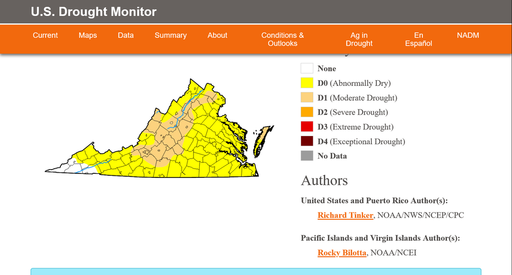
The Drought Monitor update this morning reveals an expanding area of moderate drought across Virginia. Included are Roanoke, Lynchburg, Staunton, Waynesboro and Charlottesville. It comes in to about 15 miles west of D.C..
-
58 degrees at 6 am. That's a bonus during a proclaimed heat wave! 2 degrees below normal.
-
It was fine, my high was 86. 5 degrees above normal but certainly nothing unusual for June 19.
-
65 degrees early this morning. 5 degrees above normal. Looking ahead, it is positive to see the 597 heat dome cave to a digging trough from the Lakes by Monday. This could encourage some much needed convective activity by Sunday night or Monday.
-
86 degrees at 12:45. The record high on this date in Staunton was 95 in 1921.
-
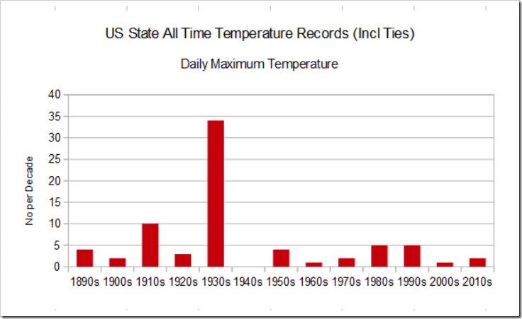
Its way too early to speculate how this summer will stack up historically. The 1930's are generally accepted as the hottest decade since 1895. 1936 witnessed more than 5000 perish from heat. From NOAA:
-
I must live on the dry side of town for this one! Didn't receive a drop.
-
High of 79 this afternoon compared to 90 expectations from all the experts. Persistent cloud cover made a huge difference.
-
Drought breeds heat..............
-
Our "new climo" hasn't really changed from 60 years ago or 100 years ago. Depending on atmospheric patterns we indeed witness almost daily occurrences of convection. Otherwise, high and dry. For a real mind trip, revisit the summer of 1963.
-
47.7 degrees at 6:15. That's 10 degrees below normal.
-
My low was 48.4 at 6 am. Augusta, Alleghany, Bath,Highland and Garrett Md. all reported some 40's. Garrett only expecting 70-75 today compared to my 76-81.
-
The 18 z Nam Nest 3 k is actually colder in Augusta than Garrett at 47 degrees at 6 am. It will be interesting as 10 degrees below normal on June 8 is noteworthy.
-
The 18z GFS has lost interest.


