PhiEaglesfan712
-
Posts
1,411 -
Joined
-
Last visited
Content Type
Profiles
Blogs
Forums
American Weather
Media Demo
Store
Gallery
Everything posted by PhiEaglesfan712
-
2025-2026 ENSO
PhiEaglesfan712 replied to 40/70 Benchmark's topic in Weather Forecasting and Discussion
We did get a good 3-week window of cold and snow between December 23 and January 15 in 1998-99. The rest of that winter (first 3 weeks of December and the 2nd half of January/February) was a torch, though. -
E PA/NJ/DE Autumn 2025 Obs/Discussion
PhiEaglesfan712 replied to PhiEaglesfan712's topic in Philadelphia Region
The best example is 89-90. We had the coldest December on record, then the weather turned springlike when the calender flipped to January. -
2025-2026 ENSO
PhiEaglesfan712 replied to 40/70 Benchmark's topic in Weather Forecasting and Discussion
That's the type of polar vortex you want for colder and snowy weather. A stronger than average polar vortex tends to favor torch conditions. -
E PA/NJ/DE Autumn 2025 Obs/Discussion
PhiEaglesfan712 replied to PhiEaglesfan712's topic in Philadelphia Region
How much do you think for EWR? -
Sorry, the Arena Football League is defunct. However, the Phillies season begins on Thursday, March 26, 2026.
-
E PA/NJ/DE Autumn 2025 Obs/Discussion
PhiEaglesfan712 replied to PhiEaglesfan712's topic in Philadelphia Region
I don't understand why you would abandon the run up 21-0, with a running back as great as Barkley, unless he is truly hurt. -
2025-2026 ENSO
PhiEaglesfan712 replied to 40/70 Benchmark's topic in Weather Forecasting and Discussion
I'm not sure exactly what is causing the warmer WPAC ocean temps. All I know is that something must have happened in between the 2009-10 strong el nino and the 2015-16 super el nino. -
December 2025 regional war/obs/disco thread
PhiEaglesfan712 replied to Torch Tiger's topic in New England
How much snow for EWR on Tuesday? -
No, I wasn't one who thought Sirianni needed to go after 2-2 last year. Heck, I didn't even lose faith after the Giants game earlier this year. I'd much rather have the losses to Bucs last year and the Giants game earlier this year. At least I can understand that we didn't have it that day. Crap like that happens sometimes. But after this loss to the Cowboys, I've completely lost faith in this team. (The last time I lost total faith in the Eagles was the loss to the Seahawks on that Monday Night in 2023, and I couldn't have been more correct.) You can't lose a game up 21-0, especially when you have a running back as great as Saquon Barkley. The Eagles never blew a 21-0 lead before, not even during the great collapse of 2023. I thought holding onto a 21-0 lead was not asking too much, but if they can't do that, then I need to lower my expectations for this team. The Eagles might beat the Raiders and split with the Commanders to get to 10 wins (and that may still be enough to win the NFC East), but this team isn't going anywhere in the playoffs. In short, this Eagles team is soft and undisciplined. Don't expect that to magically change on Friday. The Bears are a tougher team, and will beat us.
-
E PA/NJ/DE Autumn 2025 Obs/Discussion
PhiEaglesfan712 replied to PhiEaglesfan712's topic in Philadelphia Region
Now that drought guy is doubting it, I'm optimistic about this storm happening. -
2025-2026 ENSO
PhiEaglesfan712 replied to 40/70 Benchmark's topic in Weather Forecasting and Discussion
December 2010 is the only one that's reasonable. At least that happened in the newer climate. (It's not a good analog, but due to other things... like near solar min and strong la nina, features we don't have this year. Maybe it could work if we have a strong la nina in place in December 2028, when we're closer to a solar min.) December 1983 is an older, colder climate. Not likely to happen unless we have a Pinatubo event. (83-84 actually would have been a very good analog for 95-96.) December 1989, well, that was a once-in-a-lifetime event. A coldest December on record, followed by an early turn to spring (and never looking back) is almost certainly never going to happen again. -
2025-2026 ENSO
PhiEaglesfan712 replied to 40/70 Benchmark's topic in Weather Forecasting and Discussion
Funny, that year behaved the opposite of a nino (due to Pinatubo). Normally, you'd get the cool summer in the East preceding the el nino and the warm summer in the East following the el nino. Instead, the summer of 91 was a record warm summer in the East, and the summer of 92 was the cold summer in the East. Of course, Pinatubo resulted in a temporary cooling, which led the snowier winters of 92-93, 93-94, and maybe even 95-96. -
I hate to say it, but I feel the Eagles are on the verge of a 2023-type collapse. This team is way too soft to even hold on to a 21-0 lead. The offense is broken, and the defense can only hold up for so long. (In fact, I can see the defense starting to crack.) The Eagles are going to lose on Friday, and will probably end with a 9-8 or 10-7 record. That may still be good enough to win the NFC East, but we will likely lose to a team like Seattle in the Wild Card round.
-
2025-2026 ENSO
PhiEaglesfan712 replied to 40/70 Benchmark's topic in Weather Forecasting and Discussion
2020-21 is the only winter in NYC that even surpassed the 20-inch mark since 2018-19: 2019-2020 0.0 0.0 0.0 0.0 0.0 2.5 2.3 T T T T 0.0 4.8 2020-2021 0.0 0.0 0.0 0.0 0.0 10.5 2.1 26.0 T 0.0 0.0 0.0 38.6 2021-2022 0.0 0.0 0.0 0.0 T 0.2 15.3 2.0 0.4 0.0 0.0 0.0 17.9 2022-2023 0.0 0.0 0.0 0.0 0.0 T T 2.2 0.1 0.0 0.0 0.0 2.3 2023-2024 0.0 0.0 0.0 0.0 T T 2.3 5.2 T 0.0 0.0 0.0 7.5 2024-2025 0.0 0.0 0.0 0.0 0.0 2.8 3.0 7.1 0.0 0.0 0.0 0.0 12.9 -
2025-2026 ENSO
PhiEaglesfan712 replied to 40/70 Benchmark's topic in Weather Forecasting and Discussion
December 2021 was a very warm December in the Eastern US (I think only 2015 was warmer). If we're not going to get any snow in December, then I hope it's a torch. At least it can come back to average at some point in the winter (like January 2022). The worst possible outcome is a cooler December with no snow (like December 2022). -
2025-2026 ENSO
PhiEaglesfan712 replied to 40/70 Benchmark's topic in Weather Forecasting and Discussion
I'd be okay with something like December 2017, when the warm-up was very brief, and the majority of the 2nd half of December is cold. This is certainly possible. I mean, we're overdue for one. -
2025-2026 ENSO
PhiEaglesfan712 replied to 40/70 Benchmark's topic in Weather Forecasting and Discussion
The start year for this has to be 1951 because the November 25, 1950 record is just about impossible to beat out. Atlanta got to 3 degrees that day, and the places where the record low would be got to below 0. -
E PA/NJ/DE Autumn 2025 Obs/Discussion
PhiEaglesfan712 replied to PhiEaglesfan712's topic in Philadelphia Region
I guess this is another way of saying Go Birds! -
2025-2026 ENSO
PhiEaglesfan712 replied to 40/70 Benchmark's topic in Weather Forecasting and Discussion
The first week of December in 2007 was the best of that month, in regards to cold and snow. The snowstorm on the 5th was the best event until February 22nd. Although, the previous month (November) was colder than average. 2008 got going in the 2nd half of November, with a snowstorm on November 20. Again, the previous month (October) was colder than average. Weird thing about this winter is that the cold and snow didn't really align. October-January was the cold part, but the big storm was on March 1-2 (that was the beginning of about 6-7 years of great storms). -
2025-2026 ENSO
PhiEaglesfan712 replied to 40/70 Benchmark's topic in Weather Forecasting and Discussion
With the exception of 2017-18 and January 2022, the coastal areas haven't really had great snow since the mid-2010s el nino. Here is Atlantic City: 2016-2017 0.0 0.0 0.0 0.0 T T 7.2 0.3 0.2 0.0 0.0 0.0 7.7 2017-2018 0.0 0.0 0.0 0.0 0.0 10.0 14.5 T 9.6 T 0.0 0.0 34.1 2018-2019 0.0 0.0 0.0 0.0 T 4.8 4.9 6.9 1.2 0.0 0.0 0.0 17.8 2019-2020 0.0 0.0 0.0 0.0 T 0.5 T T 0.0 0.0 0.0 0.0 0.5 2020-2021 0.0 0.0 0.0 0.0 0.0 T 1.0 6.3 0.0 0.0 0.0 0.0 7.3 2021-2022 0.0 0.0 0.0 0.0 T T 33.2 0.1 T 0.0 0.0 0.0 33.3 2022-2023 0.0 0.0 0.0 0.0 0.0 T T 0.3 T 0.0 0.0 0.0 0.3 2023-2024 0.0 0.0 0.0 0.0 0.0 T 5.9 1.4 T 0.0 0.0 0.0 7.3 2024-2025 0.0 0.0 0.0 0.0 0.0 T 6.0 7.9 0.0 0.0 0.0 0.0 13.9 -
2025-2026 ENSO
PhiEaglesfan712 replied to 40/70 Benchmark's topic in Weather Forecasting and Discussion
05-06 and 20-21 are la nina years that had a colder/snowier February than January. -
2025-2026 ENSO
PhiEaglesfan712 replied to 40/70 Benchmark's topic in Weather Forecasting and Discussion
https://www.severe-weather.eu/long-range-2/la-nina-has-formed-winter-2025-2026-latest-impacts-el-nino-reversal-united-states-canada-europe-fa/
-
2025-2026 ENSO
PhiEaglesfan712 replied to 40/70 Benchmark's topic in Weather Forecasting and Discussion
Whether or not you use ONI or RONI, if you ignore what went on in Nino 1+2 last winter, then you're totally missing the picture. Last winter wasn't going to behave like a traditional la nina, or even a cold-neutral, with that warm eastern basin. -
2025-2026 ENSO
PhiEaglesfan712 replied to 40/70 Benchmark's topic in Weather Forecasting and Discussion
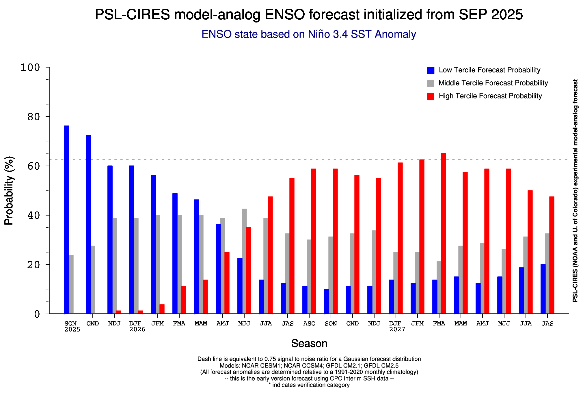
1949-51 la nina -> 1951-52 moderate el nino (yes, also continued in 1952-54) 1954-57 la nina -> 1957-58 strong el nino (yes, also continued in 1958-59) 1970-72 la nina -> 1972-73 super el nino (yes) 1974-76 la nina -> 1976-77 & 1977-78 moderate el nino (yes) 1983-85 la nina -> 1986-88 strong el nino (yes) 1988-90 la nina -> 1991-92 strong el nino (yes) 1998-2001 la nina -> 2002-03 moderate el nino (yes) 2007-09 la nina -> 2009-10 strong el nino (yes) 2010-12 la nina - no el nino in 2012-13 or 2013-14 (though we did get a super el nino in 2015-16) 2016-18 la nina -> 2018-19 weak el nino (no) 2020-23 la nina -> 2023-24 strong el nino (yes) So, within 2 years of a multi-year cold ENSO (at least one year la nina), we have: 1 no el nino (and this one eventually produced a strong el nino) 1 weak el nino 3 moderate el nino 5 strong el nino 1 super el nino Plus, 4 of these events were multi-year el ninos (1951-54, 1957-59, 1976-78, and 1986-88). -
2025-2026 ENSO
PhiEaglesfan712 replied to 40/70 Benchmark's topic in Weather Forecasting and Discussion
4 of the last 5 actually, as 09-10 was another strong el nino (along with 15-16 and 23-24). Very possible we could have a repeat of 86-89 (remember this came quickly after the 82-83 el nino), with the double el nino in 26-28, then transition to a strong la nina in 28-29. We're overdue for a strong la nina as well. We haven't had one since 10-11, which is the longest stretch without a strong la nina since 55-56 to 73-74. If we don't have a la nina by 28-29, we would have our longest stretch without a strong la nina since 1916-17 to 1955-56.