

PhiEaglesfan712
-
Posts
1,718 -
Joined
-
Last visited
Content Type
Profiles
Blogs
Forums
American Weather
Media Demo
Store
Gallery
Everything posted by PhiEaglesfan712
-
February 2026 OBS & Discussion
PhiEaglesfan712 replied to Stormlover74's topic in New York City Metro
Not on the short term, but definitely on the long term. February is still going to end up below average, but I expect things to be closer to average (and probably on the warm side) in March, and well above average in April. -
February 2026 OBS & Discussion
PhiEaglesfan712 replied to Stormlover74's topic in New York City Metro
Enjoy the cold while it last because it will pretty much be done when February is over. March will start out warm, with at least one 60+ degree day in the first week of the month. -
E PA/NJ/DE Winter 2025-26 Obs/Discussion
PhiEaglesfan712 replied to LVblizzard's topic in Philadelphia Region
Most of the rest of February looks good, if you're looking for cold air. The MJO is going to stay in Phase 3 from about 2/13 to 2/23. Around 3/1 (give or take a few days), the pattern flips warmer. I'll be shock if we don't get a temperature in the 60s during the first week of March. -
E PA/NJ/DE Winter 2025-26 Obs/Discussion
PhiEaglesfan712 replied to LVblizzard's topic in Philadelphia Region
That's my thinking for April. We're in for a Top 10 warmest April, with lots of 75, 80 degree days. -
E PA/NJ/DE Winter 2025-26 Obs/Discussion
PhiEaglesfan712 replied to LVblizzard's topic in Philadelphia Region
More like a sleet/ice storm, but I'm not thinking too warm. However, I do think a 65+ high is highly likely during the first week to 10 days of March. -
E PA/NJ/DE Winter 2025-26 Obs/Discussion
PhiEaglesfan712 replied to LVblizzard's topic in Philadelphia Region
I don't think March will be an all-out torch. I think it's above average, but around +1 or +2 departure. I see April being the torch month. -
E PA/NJ/DE Winter 2025-26 Obs/Discussion
PhiEaglesfan712 replied to LVblizzard's topic in Philadelphia Region
It's only February 8. I never said the cold would just suddenly disappear. Weather doesn't work on the flip of the switch. I said the colder than average weather would be coming to an end in the final days of February or the first days of March. That's still ~3 weeks from now. There is still time to enjoy the cold weather. I'm not so sure you'll get that opportunity next month. Besides, long and harsh winters aren't anything new. We've had such winters as recently 2009-10, 2010-11, 2013-14, and 2014-15. All but the 2013-14 one produced some very warm spring months. -
E PA/NJ/DE Winter 2025-26 Obs/Discussion
PhiEaglesfan712 replied to LVblizzard's topic in Philadelphia Region
I see it ending during the final days of February or the first days of March. After that, there will be a pattern change: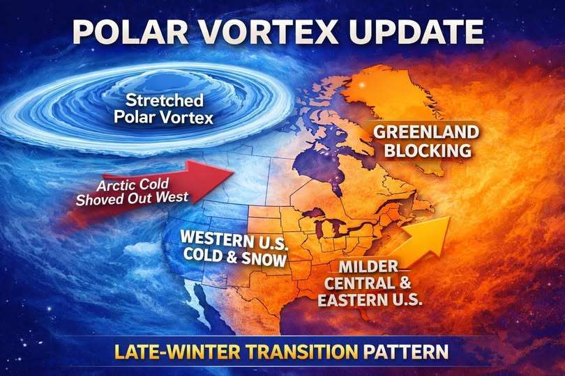
-
E PA/NJ/DE Winter 2025-26 Obs/Discussion
PhiEaglesfan712 replied to LVblizzard's topic in Philadelphia Region
Don't listen to them. When people say that the cold will never end, you know the opposite is going to happen, and cold pattern is nearing this end. Look at what happened when people on AccuWeather, in early March 2015, were saying that April and May 2015 will be colder. April ended up above average, and May was at or near record warmth. Expect March to finish with above average temperatures, and April to be a Top 10 warmest month. The only way for the cold pattern to continue is if the sun is replaced with a smaller star. (Not going to happen.) -
2025-2026 ENSO
PhiEaglesfan712 replied to 40/70 Benchmark's topic in Weather Forecasting and Discussion
I have October and November as NN, December and January BN. September is the most recent month AN. -
2025-2026 ENSO
PhiEaglesfan712 replied to 40/70 Benchmark's topic in Weather Forecasting and Discussion
It looks like we're going to be in phase 5 to end February and phase 6 to begin March. Odds favor a warm March, and probably a warm April. If there is going to be a cold and rainy month in the spring, it will be May. -
2025-2026 ENSO
PhiEaglesfan712 replied to 40/70 Benchmark's topic in Weather Forecasting and Discussion
The further time goes on, the more likely of warmer conditions in the East. A lot of the recent cold winters (2010, 2011, and 2015 are perfect examples) have had very warm spring months. -
2025-2026 ENSO
PhiEaglesfan712 replied to 40/70 Benchmark's topic in Weather Forecasting and Discussion
This is how I see March playing out:
-
2025-2026 ENSO
PhiEaglesfan712 replied to 40/70 Benchmark's topic in Weather Forecasting and Discussion
Here's the April 2015 temperature anomoly: This map doesn't look much different than those March 2026 Euro maps. -
2025-2026 ENSO
PhiEaglesfan712 replied to 40/70 Benchmark's topic in Weather Forecasting and Discussion
When you start to see people posting headlines like this, then you know to expect the opposite is most likely to happen. It's like when people on Accuweather were commenting in the beginning of March 2015 that April and May 2015 were going to be even colder. The opposite ended up happening, with May 2015 being record warm (or very close to it) in many places in the Eastern US. -
2025-2026 ENSO
PhiEaglesfan712 replied to 40/70 Benchmark's topic in Weather Forecasting and Discussion
The law of averages says a warm month has to happen at some point. The Eastern US hasn't had an above average month since September, and a near normal month since November. With the exception of 2013-14 (and even that had a warm May and June), all of the big cold years produced torch months at some point in the spring. 2010 (from March-September), 2011 (from April-July), and 2015 (in May). Even last year, March produced a Top 10 warmest month, and 2018 had the anomolously warm February, as well as a Top 10 warmest May. -
2025-2026 ENSO
PhiEaglesfan712 replied to 40/70 Benchmark's topic in Weather Forecasting and Discussion
I feel like the cold is on borrowed time. I see a 2015-type progression (just shift one month forward). I'm going with near normal mid-February, warm March, and torch April. -
2025-2026 ENSO
PhiEaglesfan712 replied to 40/70 Benchmark's topic in Weather Forecasting and Discussion
NDJ 25-26 RONI: -1.0 January 2026 PDO: -1.19 (73rd straight negative month) -
E PA/NJ/DE Winter 2025-26 Obs/Discussion
PhiEaglesfan712 replied to LVblizzard's topic in Philadelphia Region
Thing is we have had several below average months in a row. At some point, it's got to regress to the mean. If I were betting on this, seasonal mid-February, warm March, and torch April is the way to go. Just look at 2015. The bottom fell out of the thermometer in February, March was below average (mostly due to the first week), but things turned warmer in April, and May was near record warm. -
2025-2026 ENSO
PhiEaglesfan712 replied to 40/70 Benchmark's topic in Weather Forecasting and Discussion
I'd replace 2020 with 2005. 2020 was an outlier, snowless year, which will drag down the composite. -
2025-2026 ENSO
PhiEaglesfan712 replied to 40/70 Benchmark's topic in Weather Forecasting and Discussion
1993-94 (and possibly even 1995-96) was the result of the after effects of Pinatubo, our last major volcanic eruption. The cooling effects definitely wore off by the 1997-98 el nino, which was the next big global temperature jump. -
February 2026 OBS & Discussion
PhiEaglesfan712 replied to Stormlover74's topic in New York City Metro
The decade from 1982-92 was el nino/+PDO heavy. We had 3 strong/super el ninos back-to-back (82-83, 86-88, and 91-92), and a +PDO la nina (83-85). The only real break from el nino/+PDO was the strong la nina in 88-89. Not anything like 2016-present, which has been la nina/-PDO heavy. -
E PA/NJ/DE Winter 2025-26 Obs/Discussion
PhiEaglesfan712 replied to LVblizzard's topic in Philadelphia Region
When people start to say stuff like this, I almost know the opposite is going to happen. I'd be willing to bet March is going to be above average temperaturewise, and April is going to be a Top 10 warmest month, possibly even near record warm. -
E PA/NJ/DE Winter 2025-26 Obs/Discussion
PhiEaglesfan712 replied to LVblizzard's topic in Philadelphia Region
I'm just skeptical of the prospect of record 70+ degree warmth in the middle of the month. I would love for it to happen, but with how cold it has been for most of the winter and the beginning of this month, I just don't see it happening. -
February 2026 OBS & Discussion
PhiEaglesfan712 replied to Stormlover74's topic in New York City Metro
I find this list hard to believe to be correct without any February 2015 dates listed on here.


