PhiEaglesfan712
-
Posts
1,718 -
Joined
-
Last visited
Content Type
Profiles
Blogs
Forums
American Weather
Media Demo
Store
Gallery
Everything posted by PhiEaglesfan712
-
I don't think so. That was the day my brother and sister-in-law got married. I remember it being 70 and sunny in the morning, maybe a little breezy and cloudy in the afternoon during the ceremony, but no tornado.
-
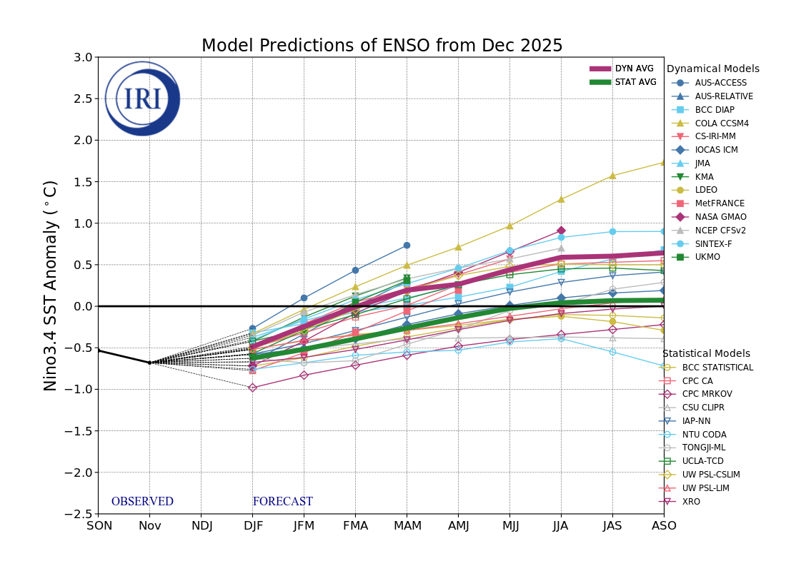
2025-2026 ENSO
PhiEaglesfan712 replied to 40/70 Benchmark's topic in Weather Forecasting and Discussion
This map is very reminiscent of fall/winter 2010-11. Of course, we had a very relaxed Pacific jet that year, which explains why we went cold in the East all the way through December and January, despite their being a deep -ENSO/-PDO/-IOD. Even when things moderated out in February and March 2011, those months weren't particularly that much warmer than average. (We eventually got the warmth that year, from April-July.) We don't have a relaxed Pacific jet this year (at least I don't think), so I'd be shocked if went cold all of January. I expect a reversion to the mean, and a torch to start at some point in January, continuing into February. -
2025-2026 ENSO
PhiEaglesfan712 replied to 40/70 Benchmark's topic in Weather Forecasting and Discussion
Yes, but I'm very skeptical of this snowstorm. They were predicting 50s on Friday until of a sudden yesterday morning, now they're predicting 30s and snow. -
2025-2026 ENSO
PhiEaglesfan712 replied to 40/70 Benchmark's topic in Weather Forecasting and Discussion
They're saying a snowstorm is going to happen. I don't know to believe it. Fun fact: On March 29, 2025, widespread upper 70s/lower 80s were observed in our area. -
2025-2026 ENSO
PhiEaglesfan712 replied to 40/70 Benchmark's topic in Weather Forecasting and Discussion
It looks like we go warm by the 2nd week of January, which makes sense, considering we haven't had a December and January go all the way cold since 2010-11: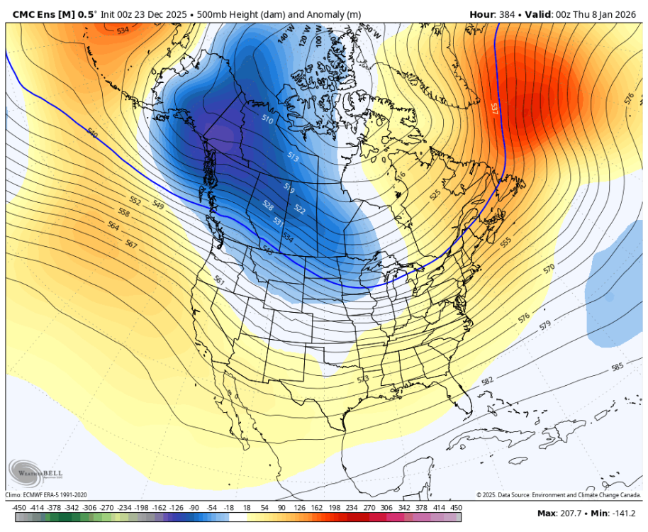
-
2025-2026 ENSO
PhiEaglesfan712 replied to 40/70 Benchmark's topic in Weather Forecasting and Discussion
March 29, 2025 (5 days out): December 26, 2025 (4.75 days out):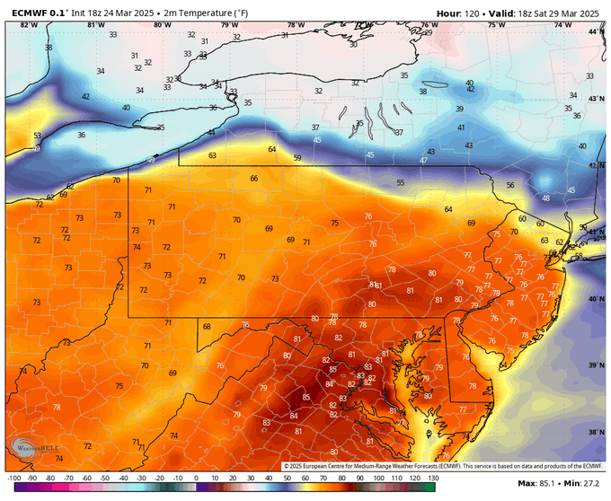

-
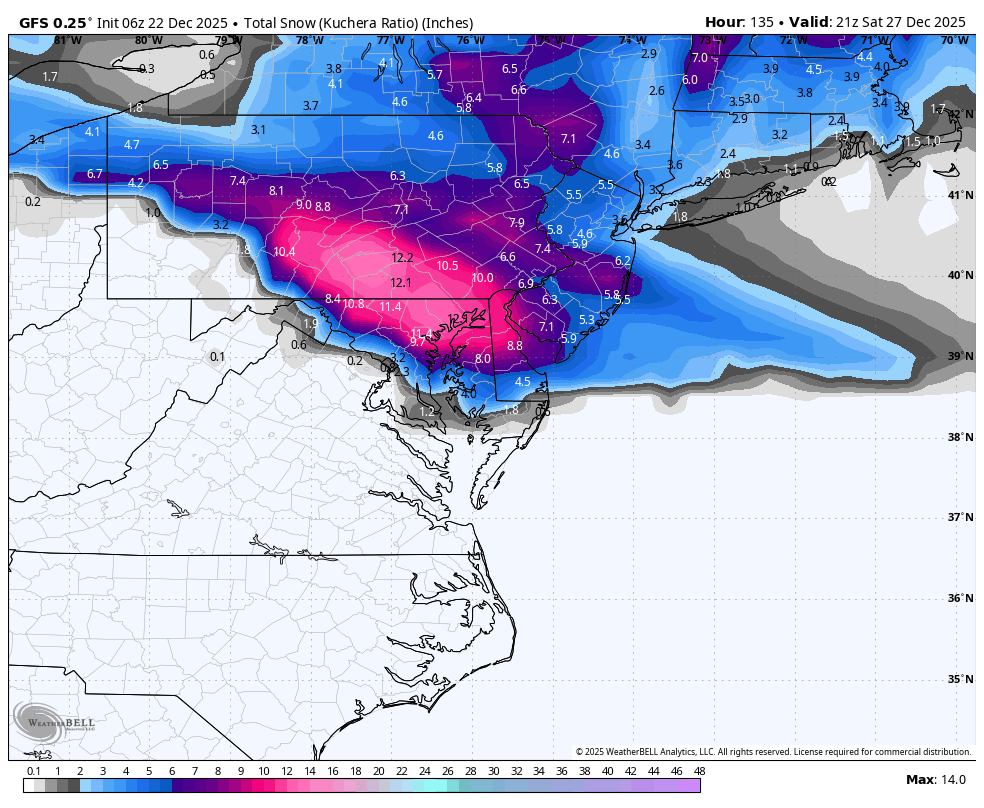
What about the 12/26/2010 snowstorm?
-
2025-2026 ENSO
PhiEaglesfan712 replied to 40/70 Benchmark's topic in Weather Forecasting and Discussion
lol, January isn't coming close to 21 inches of snow. The snowiest January since the 2016 storm was 2022, and that was 15.3 inches, and 2018 is the only other year since then that has even topped 10 inches. I'd be willing to bet that January ends up with less than 10 inches of snow and an above average temperature departure. -
E PA/NJ/DE Winter 2025-26 Obs/Discussion
PhiEaglesfan712 replied to LVblizzard's topic in Philadelphia Region
80 degrees on 3/29/2025 was the best model forecast of the year: -
E PA/NJ/DE Winter 2025-26 Obs/Discussion
PhiEaglesfan712 replied to LVblizzard's topic in Philadelphia Region
Just like I did on 3/29/2025, when in doubt, go the the NWS, which says too warm for snow: Christmas Day A chance of rain before 1pm. Cloudy, with a high near 44. Chance of precipitation is 30%. Thursday Night A chance of rain after 1am. Cloudy, with a low around 39. Chance of precipitation is 30%. Friday Rain likely. Cloudy, with a high near 57. Chance of precipitation is 70%. Friday Night A chance of rain before 1am. Mostly cloudy, with a low around 39. Chance of precipitation is 30%. Saturday Mostly cloudy, with a high near 51. Saturday Night A chance of rain. Mostly cloudy, with a low around 39. Chance of precipitation is 30%. Sunday A chance of rain. Mostly cloudy, with a high near 51. Chance of precipitation is 40%. -
E PA/NJ/DE Winter 2025-26 Obs/Discussion
PhiEaglesfan712 replied to LVblizzard's topic in Philadelphia Region
The miracle White Christmas in 1998. Temperatures really torched that month, with 2 days in the 70s in the first week, and temps in the mid-60s as late as the morning of the 22nd. Then, temperatures fell throughout the day, leading to the snowstorm on December 23-24, 1998. -
2025-2026 ENSO
PhiEaglesfan712 replied to 40/70 Benchmark's topic in Weather Forecasting and Discussion
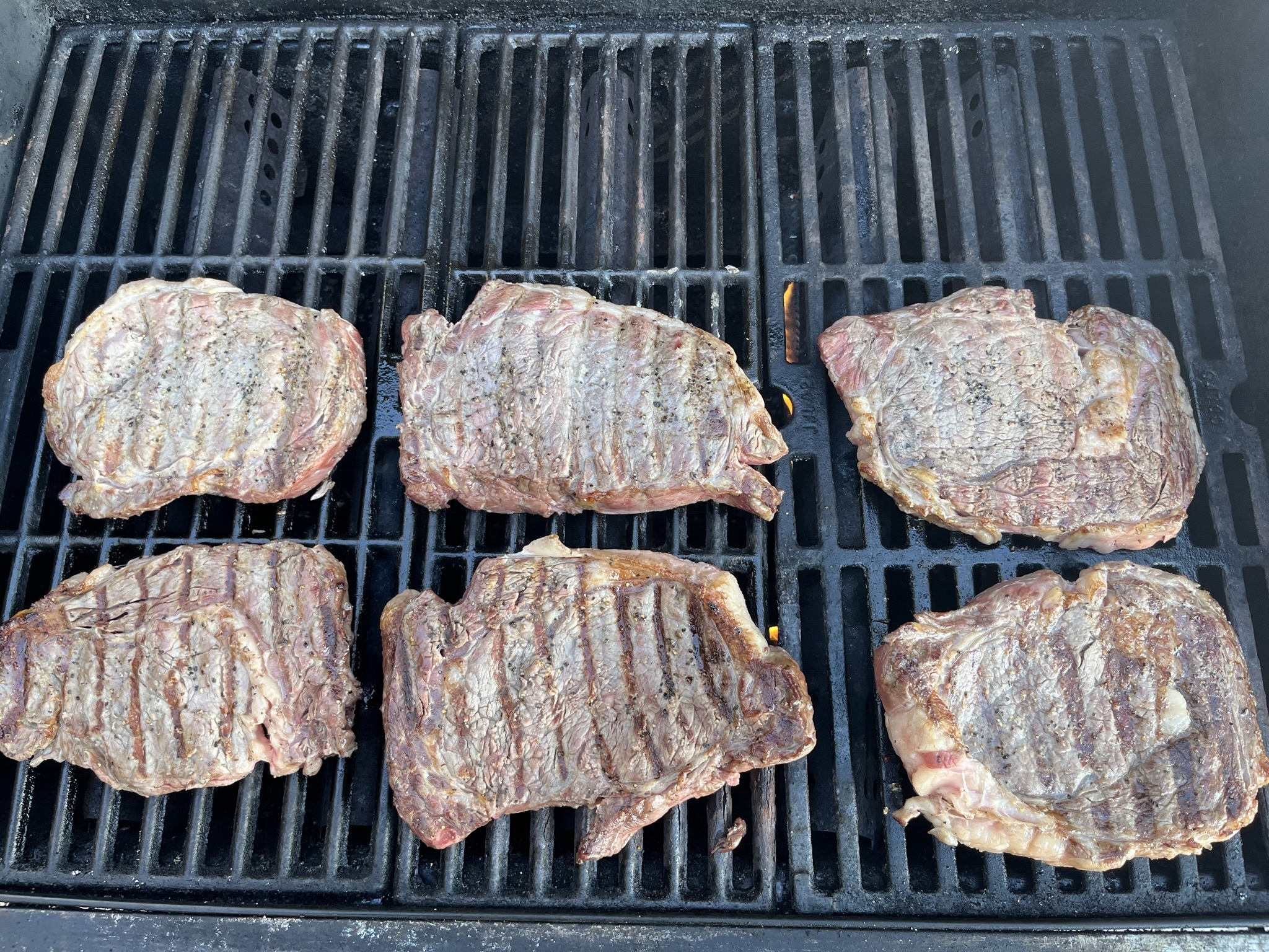
I was in North Carolina Christmas weekend in 2021, and it was really warm. I even barbecued the 26th, and have the pictures to prove it: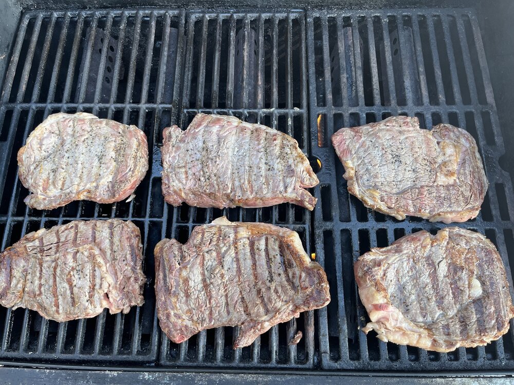
-
2025-2026 ENSO
PhiEaglesfan712 replied to 40/70 Benchmark's topic in Weather Forecasting and Discussion


-
2025-2026 ENSO
PhiEaglesfan712 replied to 40/70 Benchmark's topic in Weather Forecasting and Discussion
Oh please, no March 2001. I would not wish that on any snow lover. I'd prefer March 2017 as an analog. -
E PA/NJ/DE Winter 2025-26 Obs/Discussion
PhiEaglesfan712 replied to LVblizzard's topic in Philadelphia Region
Does this mean an early start to spring? -
2025-2026 ENSO
PhiEaglesfan712 replied to 40/70 Benchmark's topic in Weather Forecasting and Discussion
2000-01 was the most disappointing in my lifetime. I know this one technically ended with above average snowfall, but the epic snow bust in early March left a very sour taste. Oh what could have been if the forecast had even come close to verifying. -
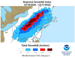
Today is the 5th anniversary of the December 2020 snowstorm. This weekend's snowstorm was the biggest December snowstorm since then.
-
I was too young (about a year and a half), but the weather records show that the January 1990 average temperature was 15 degrees warmer than the December 1989 average temperature. That type of temperature jump is something you see from March -> April or April -> May. You don't see that in the dead of winter. It's like spring began in January that season.
-
2025-2026 ENSO
PhiEaglesfan712 replied to 40/70 Benchmark's topic in Weather Forecasting and Discussion
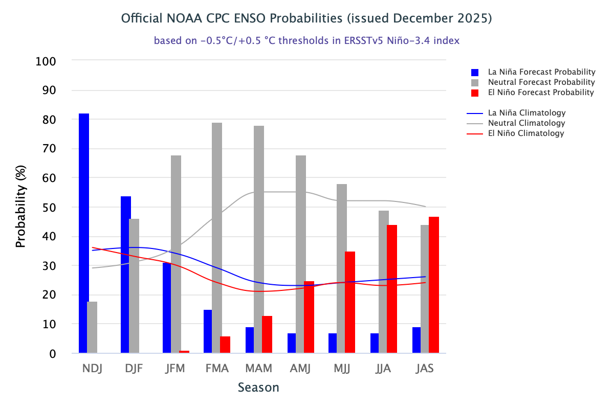
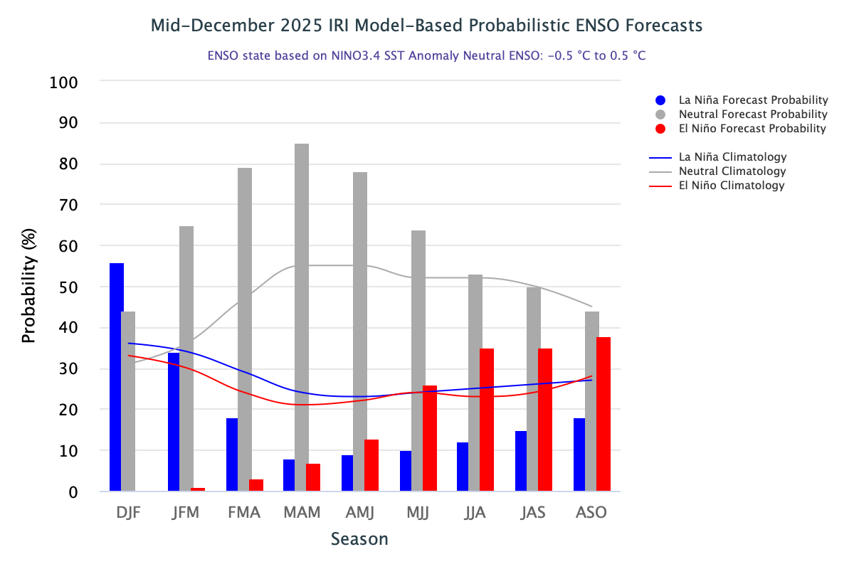
The most obvious ones are the most recent: 2016-17 and 2022-23. In case you forgot, here's what happened the last time a dissipating la nina led into an el nino: -
2025-2026 ENSO
PhiEaglesfan712 replied to 40/70 Benchmark's topic in Weather Forecasting and Discussion
Previous years with similar ENSO/IOD/PDO patterns. They tend to have cool Decembers, but torch in January and February. -
2025-2026 ENSO
PhiEaglesfan712 replied to 40/70 Benchmark's topic in Weather Forecasting and Discussion
January and February are going to torch. 16-17 is probably the best analog. This could be a great snow season if you live in Syracuse. Not so much if you live in Atlantic City. -
2025-2026 ENSO
PhiEaglesfan712 replied to 40/70 Benchmark's topic in Weather Forecasting and Discussion
16-17 was generally a torch in January and February in the Eastern US. It just had a very odd distribution of snow. It was the snowiest season ever in Syracuse (almost 160 inches). But places like Baltimore and DC only got ~3 inches of snow. Talk about a very sharp cutoff. 08-09 is another weird one. Despite how cold October-January was, it would have went below average on snow without the KU on March 1-2.
-
2025-2026 ENSO
PhiEaglesfan712 replied to 40/70 Benchmark's topic in Weather Forecasting and Discussion
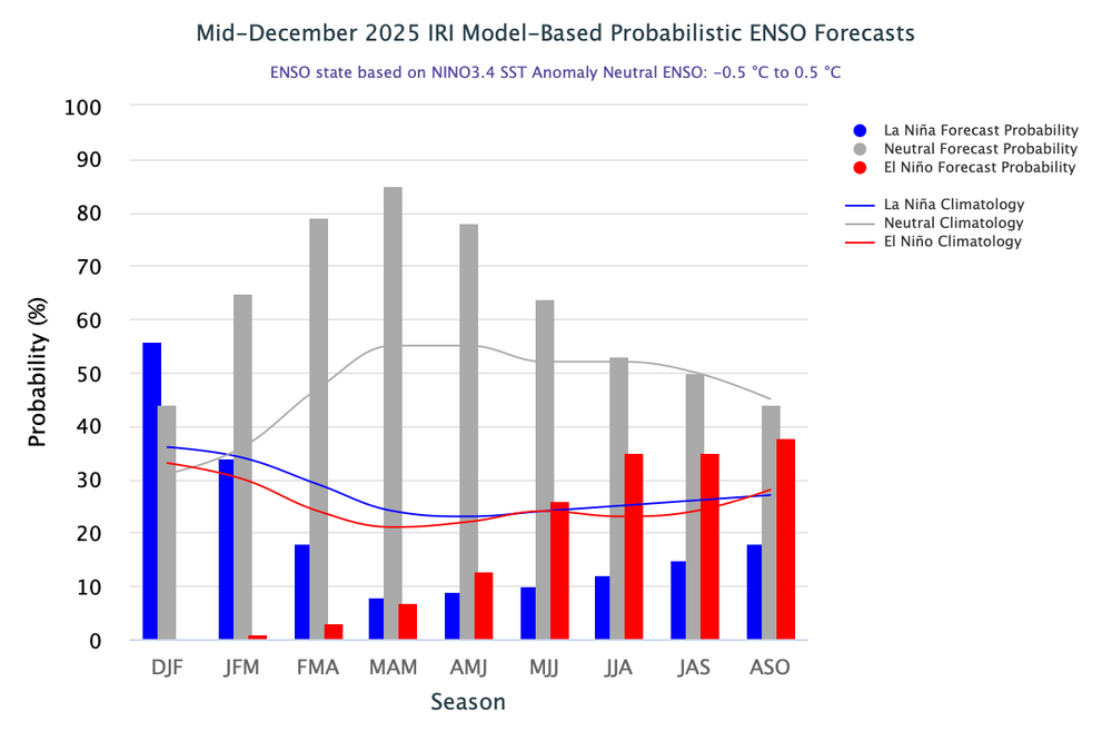
Looks like it's completely in the center. That's a bullseye if we're playing darts. -
2025-2026 ENSO
PhiEaglesfan712 replied to 40/70 Benchmark's topic in Weather Forecasting and Discussion
World News Tonight got the year of the last December snowstorm wrong. It was in 2020, not 2018: https://x.com/ABCWorldNews/status/2000383451434774960 You would think this would be fact-checked before a major news organization like ABC airs it. -
E PA/NJ/DE Winter 2025-26 Obs/Discussion
PhiEaglesfan712 replied to LVblizzard's topic in Philadelphia Region
1995-1996 -> That one was a wall-to-wall great winter. 2000-2001 -> Okay winter overall, but left a very sour taste with the huge snow bust in March. 2005-2006 -> Very mild January, but a return to winter in February, highlighted by the snowstorm on the 11th-12th. March is mild. 2010-2011 -> Very cold and snowy January, turns milder in February, although a moderate snowfall happens around President's Day. No more snow after that, but we do get one last hurrah of well below average temperatures in late March. 2020-2021 -> January has no snow and above average temperatures until the last day of the month. February is cold and snowy. March is mild.